Where the Sheep Rancher Planted Stars
Fred Galbreath was not a rancher by trade. He sold marine insurance in San Francisco, the kind of work that teaches you to calculate risk and think in long timelines. In 1944 he bought 3,670 acres of worn-out sheep country in the Outer Coast Range of Mendocino County, seventeen miles from the Pacific, and began a project that would outlast him. He hunted the invasive wild boars himself. He regraded the drainage to stop sediment from choking Rancheria Creek. He thinned diseased trees with the patience of someone who understood that a forest, like a hull, needs maintenance nobody sees. When Galbreath died in 2000 at the age of ninety-eight, his family donated the land to Sonoma State University. The preserve that carries his name is not a monument to pristine wilderness. It is a monument to repair.
The Upstreamers' Country
Long before any sheep grazed these hills, the Central Pomo people moved through this landscape according to rhythms that European settlers would never fully understand. Coastal Pomo called the people who lived along Rancheria Creek the Danokeya -- the "upstreamers" -- and their principal village of Late stood on the creek's west bank about a mile from present-day Yorkville. Smaller settlements dotted the drainage: Polma, Kalaicolem, Lali. The tribelet communities, consisting of a hundred to two thousand people linked by extended kinship, governed themselves through councils of family headmen. They traveled seasonally to Clear Lake for its fisheries and obsidian, to the coast for clams, and through neighboring Pomo territories with an ease that reflected generations of maintained relationships. Because the nearest Spanish mission was far south in Sonoma, the Central Pomo were largely spared the forced labor and displacement that devastated other California tribes during the Mission Period.
Cut, Grazed, and Drained
The American settlers who arrived after 1848 saw the land differently. By 1884, the General Land Office map recorded a house belonging to someone named Livingston on what would become the preserve, along with trails connecting the remote interior to Cloverdale and Whitehall. The redwoods and Douglas fir that had canopied these canyons for centuries fell to industrial logging between the late 1800s and early 1900s. What the loggers left, the ranchers filled with livestock. The hills were productive but degraded -- eroding soil, silting streams, invasive species moving into gaps the native ecology could no longer defend. When Galbreath arrived in 1944, he inherited a landscape that had been used hard for nearly a century. His response was not to exploit what remained but to begin the slow work of putting it back together.
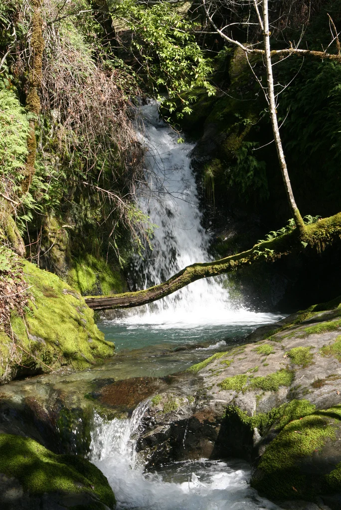
A Living Laboratory
Today the preserve sprawls across ridgelines and canyons that range from 900 feet to over 2,000 feet in elevation, right at the edge of where coastal fog reaches inland. That boundary makes the ecology unusually varied for a single property. Douglas fir and second-growth redwood share the slopes with tanoak, madrone, and nine species of oak. The grasslands roll between patches of forest like clearings in a puzzle. Rancheria Creek, which flows north through the heart of the preserve before joining the Navarro River, dries up in summer along its main channel -- but tributaries like Yale Creek, tucked in steep canyons, hold water year-round. Mountain lions, black bears, golden eagles, and bobcats still hunt here. Northern California steelhead, listed as federally threatened, still make the journey from the ocean up through the Navarro watershed to spawn in these waters, though their numbers have fallen far from what they were when fish and game crews rescued large numbers of coho and steelhead from drying pools in the early 1950s.
The Telescope and the Creek
Sonoma State University runs the preserve as a research and teaching site, and the facilities reflect its remoteness. Two campgrounds -- one along the creek with a fire ring, one near the entrance with a composting toilet -- offer the only overnight accommodations. Visitors bring their own water. An eight-mile dirt road, passable only by four-wheel drive, threads across the property; after rain, even that road closes. Cell reception exists at exactly two spots on the entire 3,670 acres. But the university has plans that match the ambition of Galbreath's original vision. Among them is a remotely operated one-meter telescope, designed to search for extrasolar planets and near-Earth asteroids. The man who spent half a century nursing a sheep ranch back to health would have appreciated the logic: fix the ground beneath your feet, then look up.
From the Air
The Galbreath Wildlands Preserve is located at approximately 38.87N, 123.26W in the Outer Coast Range of southern Mendocino County. The terrain is rugged and heavily forested, with elevations from 900 to over 2,000 feet. From the air, look for the Rancheria Creek drainage flowing northward toward the Navarro River, with a mosaic of conifer forest, oak woodland, and grassland. The nearest town is Yorkville, about 5 miles away. Cloverdale (20 miles) and Boonville (18 miles) are the closest significant settlements. The nearest airports are Sonoma County Airport (KSTS) in Santa Rosa, approximately 45 nautical miles southeast, and Ukiah Municipal Airport (KUKI), about 30 nautical miles north. Coastal fog frequently blankets the area from the west.
Nearby Stories
- The Valley That Drowned 6.2 km away
- Anderson Marsh State Historic Park 6.2 km away
- The River Beneath the Vines 6.5 km away
- People From the Top of the Land 10 km away
- Sites Reservoir 35 km away
- Pixieland 648 km away
- Neskowin Ghost Forest 686 km away
- ʻAkaka Falls State Park 3666 km away