The River Beneath the Vines
Everyone knows the Napa Valley for its wine. Fewer notice the river. It threads the valley floor like a seam, beginning as a seasonal trickle called Kimball Canyon Creek on the southern slope of Mount Saint Helena, at an elevation of 3,745 feet inside Robert Louis Stevenson State Park. From there it flows fifty-five miles south through Calistoga, St. Helena, Rutherford, Oakville, and Napa before widening into a tidal estuary that empties through the Napa Sonoma Marsh into San Pablo Bay. The vineyards that made this valley famous depend on the river's watershed for irrigation and drainage. But the Napa River has its own story -- one of salmon fighting upstream past dams, beavers reclaiming their ancestral territory, catastrophic floods, and a hard-won effort to undo decades of damage.
Born on a Volcano
The Napa River's source is Mount Saint Helena, a 4,342-foot peak in the Mayacamas Mountains where the California Coast Ranges make their last significant stand before the terrain flattens toward the Sacramento Valley. Kimball Canyon Creek descends the mountain's southern slope to Kimball Canyon Dam, one of several large dams built between 1924 and 1959 on the river's tributaries. From there the river enters the head of the Napa Valley north of Calistoga and begins its long southward journey. The watershed it drains encompasses roughly 426 square miles, fed by tributaries with names that sound like characters in a Western: Dry Creek, Conn Creek, Soda Creek. The Mayacamas and Vaca mountain ranges funnel rainfall into the valley from both sides, creating the well-drained, mineral-rich soils that viticulturists prize. From the air, the river is the valley's central thread, its riparian corridor a narrow green line winding through a patchwork of vineyards.
The Fish That Shouldn't Be Here
The Napa River once supported spawning runs of 6,000 to 8,000 steelhead and as many as 2,000 to 4,000 coho salmon. Dams, water diversions, and habitat degradation dismantled those populations methodically. By the late 1960s, coho salmon were gone from the watershed entirely, and the steelhead run had dwindled to fewer than a few hundred adults. Then, in 2013, a genetics study produced a startling discovery. Four juvenile Chinook salmon collected from the Napa River in 2010 turned out to be siblings -- and their DNA matched Klamath River Chinook, a population from over 300 miles to the north. Two adults had somehow migrated from the Klamath, entered the Napa River, and successfully spawned. The finding carried real implications: the Napa River had not been included in the federally protected Coastal California Chinook Salmon ESU, but here were Klamath fish making it their home regardless. Nature was quietly rewriting the conservation map.
A Flood That Changed Everything
Twenty-three floods have been recorded on the Napa River since 1865, but the worst struck in 1986. The river overwhelmed its banks and poured into the city of Napa, forcing the evacuation of 7,000 people, destroying 250 homes, and killing three. The disaster jolted a dormant flood control project back to life. After a lengthy redesign, voters approved the Napa River Flood Project in 1998 -- a plan that rejected the usual concrete-channel approach in favor of something more ambitious: giving the river room. Construction began in 2000 and concluded in 2015, incorporating setback levees, restored wetlands, and a downtown bypass channel. The project became a national model for flood management that works with a river's natural tendencies rather than against them.
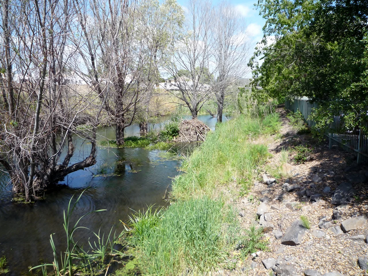
Beavers, Gondolas, and Daylight
The Napa River's restoration has produced some unexpected residents. North American beavers, historically present but long absent, have recolonized stretches of the river near Napa, Rutherford, and Oak Knoll, building three to four dams that create pools beneficial to fish and other wildlife. Meanwhile, the Rutherford Restoration Project has persuaded 23 vineyard owners along a 4.5-mile stretch between St. Helena and Oakville to return 18 acres of prime land to a natural riparian state. In the 1970s, Napa Creek -- a tributary running through downtown -- had its concrete culvert removed, re-exposing the water to daylight in what may have been one of the country's earliest stream daylighting projects, though the work was done for urban renewal rather than ecological reasons. The lower river offers a different kind of discovery: flatwater paddling from Napa to San Pablo Bay, and even an Italian-style gondola cruise through the city's restored waterfront.
Where the Water Meets the Bay
South of Napa, the river transforms. The current slows, salt water pushes upstream with the tides, and the banks dissolve into the vast Napa Sonoma Marsh. This estuary is where the river's fresh water meets the brackish influence of San Pablo Bay, creating an intertidal zone that supports a web of life from migratory shorebirds to juvenile fish seeking sheltered nursery habitat. Former salt ponds along the southern river are being restored to their natural marsh state, reversing over a century of industrial use. The river finally enters Mare Island Strait, a narrow channel on the north side of San Pablo Bay near Vallejo, and discharges into the bay through the marsh. From the air, the transition is dramatic: ordered rows of vineyards give way to the organic curves of wetland channels, a landscape where human control yields to tidal rhythms. It is a fitting conclusion for a river that has spent its entire length negotiating between nature and the demands people place upon it.
From the Air
The Napa River runs roughly 55 miles from its source near Mount Saint Helena (38.664N, 122.621W) south through the Napa Valley to San Pablo Bay. The river is best traced from 3,000-4,000 ft AGL, where its riparian corridor contrasts with surrounding vineyards. The Napa Sonoma Marsh at the southern end is a prominent wetland feature. Napa County Airport (KAPC) lies along the river's lower course. Nut Tree Airport (KVCB) is approximately 10 nm east. Watch for terrain on both sides of the valley: Mayacamas range to the west, Vaca Mountains to the east, both rising to 2,000+ ft.
Nearby Stories
- Bodega Head: Where Two Plates Meet 1.9 km away
- Austin Creek State Recreation Area 2 km away
- The City of San Francisco 4.4 km away
- Vallejo's Sonoma: Where California Changed Hands 5.6 km away
- The Rocky Fire: When a Water Heater Burned 69,000 Acres 5.7 km away
- From Radio Towers to Tribal College: D-Q University 9.3 km away
- The People of the Roundhouse 15 km away
- The Day Two Nuclear Bombs Fell on Yuba City 31 km away