Gunung Padang: Java's Stairway to the Ancient World
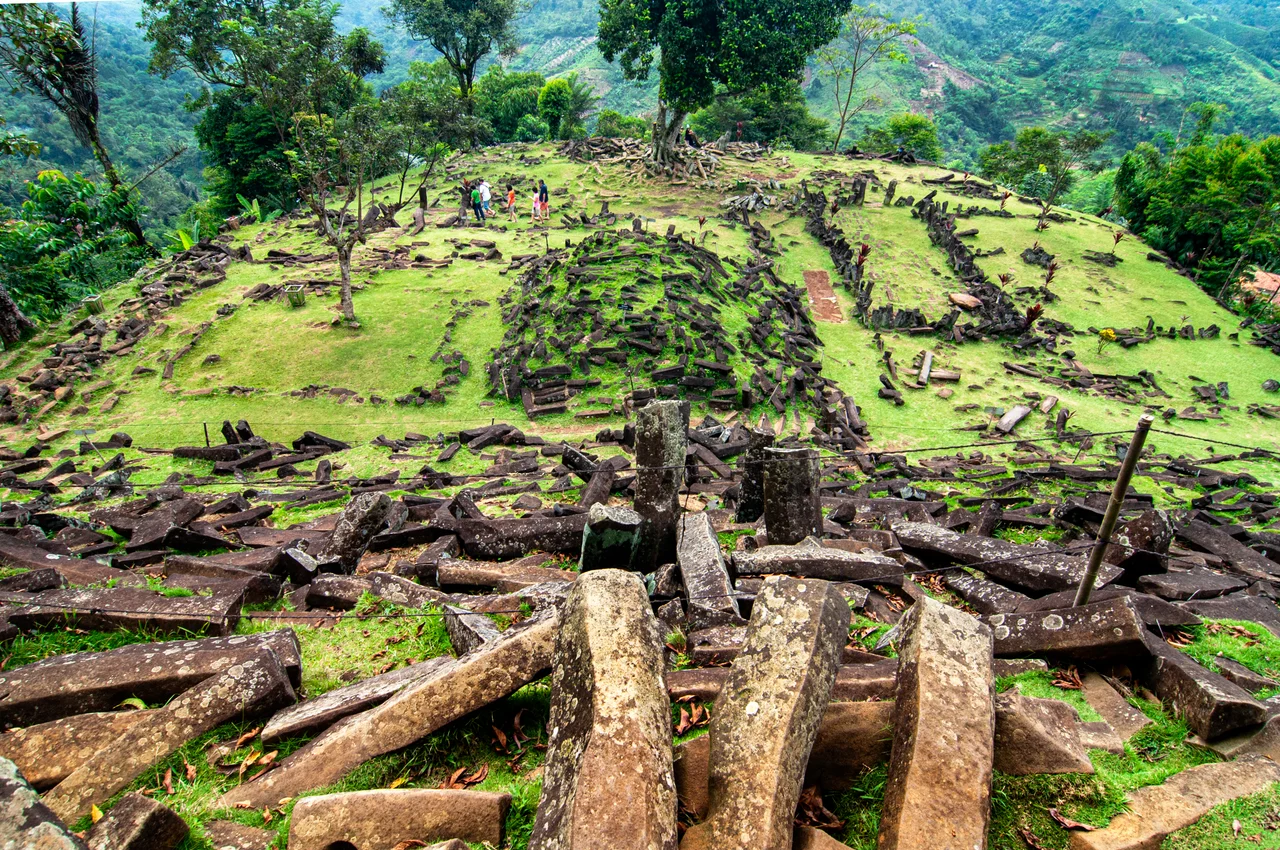
Three hundred and seventy steps of dark andesite climb the flank of an extinct volcano in West Java. At the top, massive hexagonal stone columns lie scattered across five terraces, arranged in patterns that look too deliberate to be accidental but too ancient to be easily explained. This is Gunung Padang, Indonesia's largest megalithic site, a place where the Sundanese people say King Siliwangi once tried to build a palace in a single night. Whether or not you believe the legend, the stones demand an explanation - and the one you choose says a great deal about how you think the past worked.
The Bones of a Volcano
Gunung Padang sits at 885 meters above sea level, perched on the edge of a deeply eroded circular basin that geologists identify as the caldera of the Karyamukti composite paleovolcano. The rock beneath the terraces is old - potassium-argon dating places the underlying andesite intrusion at roughly 32 million years. Two fault lines intersect here: the Cimandiri fault running west-northwest to east-northeast, and the Gede-Cikondang fault cutting north-northwest to south-southeast. That intersection created the geological conditions for the columnar jointing visible on the surface - hexagonal columns of volcanic rock that fracture naturally along geometric planes as lava cools. The columns look carved, but they are the work of thermodynamics. Understanding this geology matters, because it sits at the heart of the fiercest argument Gunung Padang has provoked.
Lost, Found, and Fought Over
Dutch historian Rogier Verbeek first documented the site in 1891, based on a visit by M. De Corte the previous year. Archaeologist Nicolaas Johannes Krom noted it again in 1914 in a report for the Department of Antiquities. Then Gunung Padang disappeared from scholarly attention for sixty-five years. In 1979, a group of local farmers stumbled upon the terraces, and the Bandung Institute of Archaeology rushed to investigate. Mainstream archaeologists dated the structures to somewhere between the 2nd and 8th centuries CE - pottery fragments found at the site fell in the range of 45 BCE to 22 CE. A respectable age for a megalithic monument, but not an extraordinary one. Then came the controversy. Indonesian geologist Danny Hilman Natawidjaja claimed the site was actually a giant pyramid built 9,000 to 20,000 years ago, evidence of an advanced civilization lost to history. The claim captured the imagination of President Susilo Bambang Yudhoyono, who established a government task force. It also drew sharp criticism from the scientific community. Volcanologist Sutikno Bronto concluded the formation was simply the neck of an ancient volcano. Archaeologist Victor Perez called Natawidjaja's work pseudoarchaeology. A paper supporting the fringe hypothesis was retracted from a peer-reviewed journal.
Sacred Ground
For the Sundanese communities of West Java, the academic debate is largely beside the point. Gunung Padang has been sacred ground for centuries, woven into the story of Prabu Siliwangi, the semi-legendary king of the Pajajaran kingdom. Local tradition holds that he attempted to construct a palace here overnight, and when dawn broke before the work was finished, the unfinished columns were left where they fell. The site's name translates roughly as "Mountain of Enlightenment," and visitors climbing the 370 steps often encounter offerings left among the stones. The terraces themselves, bordered by retaining walls and rising roughly 95 meters up the hillside, carry a sense of intentional arrangement that even skeptical geologists acknowledge - human hands shaped this place, even if the raw material was volcanic. That tension between the natural and the constructed is what makes Gunung Padang so compelling. The columns are undeniably geological. The terracing is undeniably human. Where one ends and the other begins is the question that keeps drawing researchers back to these slopes.
The View from Above
From the air, Gunung Padang appears as a forested hilltop partially encircled by the curved ridge of Gunung Empet, sitting inside what satellite imagery reveals as the remnant caldera. The surrounding landscape is classic West Javanese highland: steep-sided volcanic hills, narrow ridges, and deeply dissected valleys carved by millions of years of tropical rainfall. To the north, the hills of Gunung Malang, Pasir Domas, and Pasir Pogor mark the interior of the ancient basin. The site lies about 50 kilometers southwest of Cianjur, tucked into terrain that feels remote despite its proximity to some of Java's most densely populated corridors. Visitors who make the journey from Bandung or Jakarta find themselves trading highway congestion for winding mountain roads that climb through tea plantations and rice terraces before arriving at the base of the steps.
From the Air
Located at approximately -6.994 lat, 107.056 lng, 885 meters above sea level in the highlands southwest of Cianjur, West Java. The site appears as a forested hilltop within the curved ridge of Gunung Empet. Nearest major airport is Husein Sastranegara (WICC) in Bandung, roughly 80 km to the east. Halim Perdanakusuma (WIHH) in Jakarta is approximately 130 km to the northwest. Best viewed at lower altitudes; the volcanic terrain and steep ridges of the surrounding Karyamukti caldera are visible at moderate zoom.
Nearby Stories
- Astana Anyar Bombing 3 km away
- Citarum River 8.5 km away
- Battle of Kalijati 19 km away
- The Inscribed Stone of Pakuan 27 km away
- Where the Gods Were Smiling 50 km away
- The Crossing at Silebu 64 km away
- The Scholar's Mosque 107 km away
- SIEV X 331 km away