Halaib Triangle
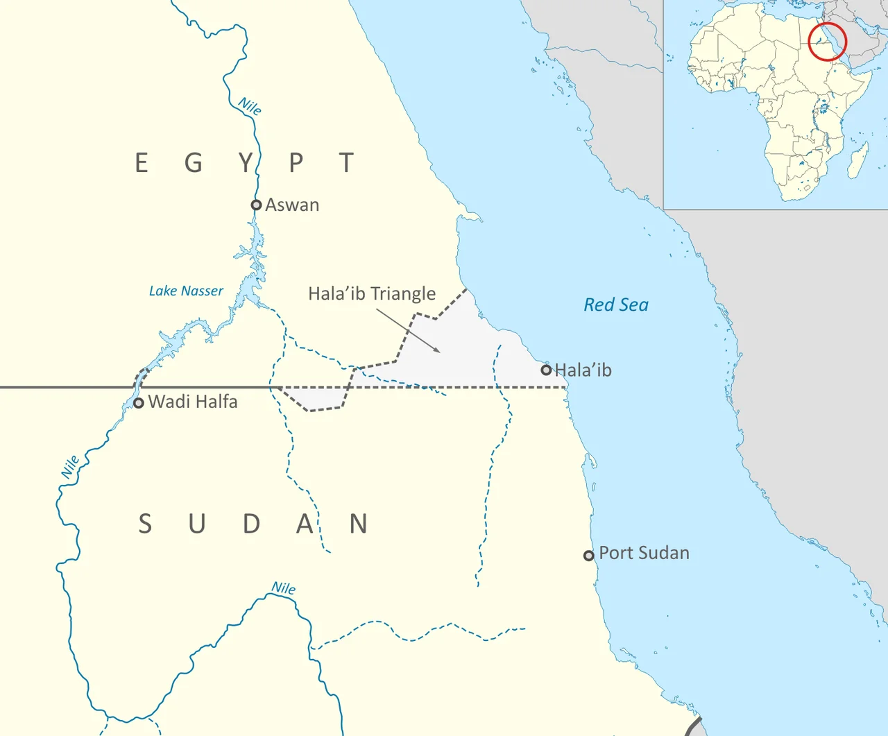
Two maps of the same territory, drawn three years apart by the same colonial power, disagree. That is the whole story of the Halaib Triangle - and also the start of it. On 19 January 1899, an Anglo-Egyptian agreement defined Sudan as the territories south of the 22nd parallel, drawing a straight line across the desert. In 1902, British administrators adjusted for geography and tribes and drew an "administrative" boundary that followed people rather than latitude, looping a chunk of land north of the parallel into the Sudanese side. The 20,580 square kilometers between those two lines became the Halaib Triangle. For most of the 20th century the ambiguity did not matter much. It matters enormously now.
The Line and the Line
The town of Halaib sits on the Red Sea coast at roughly 22.47 degrees north, a few kilometers above the 1899 political boundary. The Bisharin, Ababda, Rashaida, Hamad-Orab and Aliyaab people who live in the triangle were largely Beja - cousins of Sudan's Red Sea communities in language, custom, and family lines. For decades both Cairo and Khartoum lived with the contradiction. Sudan administered Halaib after independence in 1956; it was part of Red Sea State; its people voted in Sudanese elections through the late 1980s. Then in 1992 Sudan granted offshore exploration rights to a Canadian oil company. Egypt objected. The company walked. Tensions sharpened. After a 1995 attempt on Egyptian President Hosni Mubarak's life in Addis Ababa - an attack Egypt blamed on Sudan - Egyptian forces moved in and expelled Sudanese police and officials. De facto Egyptian control has held ever since.
The People in Between
About 27,000 people live in the Halaib Triangle as of 2021. Their lives bend around the border dispute in ways both petty and profound. A 2010 open letter from Muhammad Al-Hassan Okair, who had represented Halaib in Sudan's 1995 parliament, described the situation from the ground: 20 villages folded into Egyptian electoral districts without consultation, barbed wire around Halaib, goods from Sudan blocked at checkpoints, and - the detail that cut closest - Bisharin camels forbidden to graze the ancestral pastures their owners had used for generations between Halaib and the Nile. In April 2010, former Halaib Council head Al-Taher Muhammad Hasaay died in a Cairo hospital after two years of detention without trial. Seven others from the Bisharin remained in Egyptian custody, some for as long as six years. The Egyptian newspaper Al-Masry Al-Youm reported in July 2010 that tribal chiefs from the Ababda, Bishareen, and Rashaida had declared themselves Egyptian citizens - holding national ID cards, serving in the Egyptian military. Both stories are true, which is how disputed territory usually works.
The Diplomatic Deep Freeze
Sudan has never formally relinquished the claim. President Omar al-Bashir said in 2010 that "Halayeb is Sudanese and will always be Sudanese." The Eastern Front, a Sudanese coalition including the Beja Congress and Free Lions, has argued for international arbitration on the model used at Abyei between north and south Sudan. Egypt has consistently refused arbitration or even negotiation. Its 2016 Foreign Ministry position was a brief statement: these are Egyptian territories, subject to Egyptian sovereignty, and there will be no further comment. The practical sovereignty question is settled by who holds the ground. The legal question is not settled at all, and every few years somebody tests it - a Sudanese election delegation turned back at the border in 2009, a presidential assistant barred in the same year - and then the matter lapses back into silence.
Mountains That Belong to Africa
Geographically, the Halaib Triangle is an extraordinary place. It is where Afrotropical ecology reaches its northernmost limit - at Gebel Elba, a mountain massif that rises to 1,435 meters and catches enough moisture from the Red Sea to support dense acacias and mangrove coves. The larger peaks, Mount Shendib at 1,911 meters and Mount Shendodai at 1,526 meters, form a small island of tropical Africa in what would otherwise be Egyptian Sahara. Rare plants grow here that grow nowhere else - Biscutella elbensis, for instance. Egypt has designated Gebel Elba a nature reserve. Since 2010 a paved road has connected the triangle to Port Sudan. An Egyptian electrical grid extension was reaching Halaib as of 2009. The infrastructure shapes facts on the ground. The maps have not caught up with themselves.
The Curious Case of Bir Tawil
There is a footnote that travelers love: just south of the 22nd parallel, on the desert side, lies Bir Tawil - a 2,060 square kilometer trapezoid of land that neither Egypt nor Sudan claims. The same 1899-versus-1902 cartographic quarrel that gave the Halaib Triangle to two countries simultaneously gave Bir Tawil to neither. Egypt accepts the 1899 political line, which means Bir Tawil is Sudanese; Sudan accepts the 1902 administrative line, which means Bir Tawil is Egyptian. Each country's preferred border logic hands the bigger, coastal Halaib to itself and the smaller, empty Bir Tawil to the other. Bir Tawil is one of only a small handful of terra nullius territories on the planet. You can apply for a visa to visit by emailing a man in Cairo. The Halaib Triangle, the opposite problem, welcomes no visas at all.
From the Air
Halaib Triangle coordinates approximately 22.47°N, 35.52°E on the African coast of the Red Sea, between Egyptian administrative centers at Shalatin/Alshalateen and Sudan's Port Sudan. Disputed territory - overflight governed by Egyptian air traffic control in practice. Nearest airports: Marsa Alam International (HEMA) ~200 km north, Port Sudan New International (HSPN) ~250 km south. Gebel Elba mountain (1,435 m) visible as a sharp rise above coastal desert from FL250+.
Nearby Stories
- The Travels of Ibn Battuta 30 km away
- Zabargad Island 116 km away
- Wadi Allaqi 119 km away
- Bir Tawil 150 km away
- Red Sea 185 km away
- Wadi El Gemal National Park 187 km away
- Bi'r Tawīl 203 km away
- Battle of Badr 286 km away