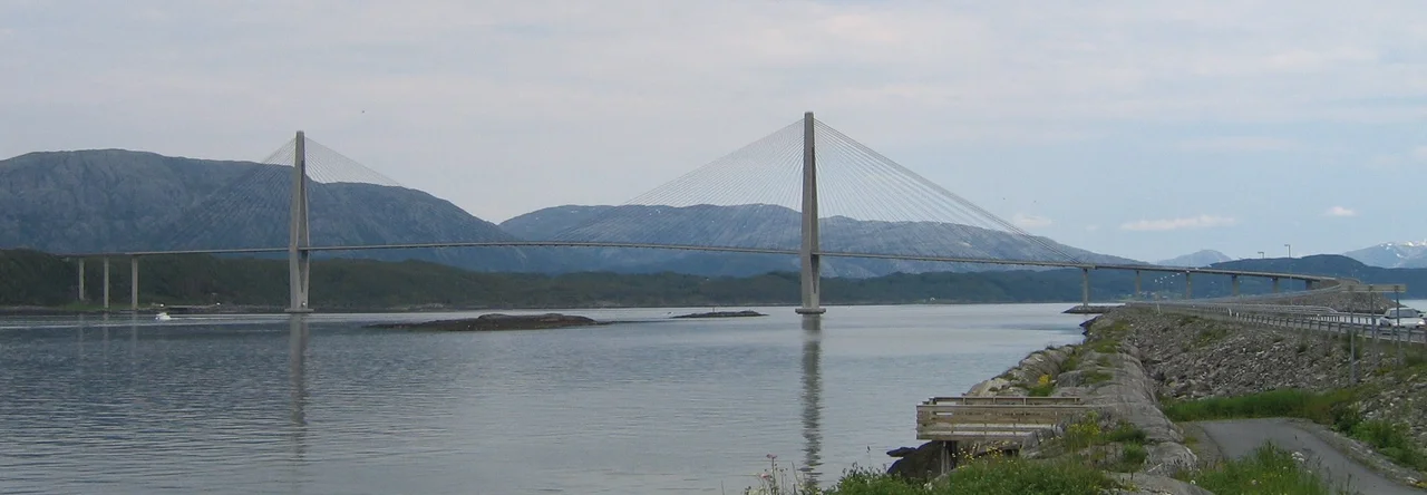

Helgeland Bridge
One point two metres. That is the depth of the concrete box girder that carries traffic 425 metres across the Leirfjorden in Nordland — a deck barely deeper than a doorway is wide, holding up a span longer than most suspension bridges of its era. Seen from a boat underneath, the Helgeland Bridge hardly reads as a structure at all. It reads as a drawn line: a pale stroke pulled taut between two towers, with the wall of the Seven Sisters mountains standing behind it. That thinness is not a flourish or a happy accident. It is the whole argument of the design, and it made the bridge one of the most-studied concrete crossings in Europe when it opened in July 1991.
A Ratio of 1 to 354
Divide the 425-metre main span by the 1.2-metre depth of the girder that spans it and you get roughly 354. Engineers call that number slenderness, and at 1:354 the Helgeland Bridge pushed the figure further than concrete cable-stayed construction had gone before. The deck is only twelve metres wide, its edges shaped aerodynamically so that the wind coming down the fjord slips past rather than shoving. Everything the deck cannot carry by depth, it borrows from the cables: fans of steel stays running up to twin towers that rise 138 metres above the water. The result is a bridge that looks almost provisional and behaves like nothing of the kind. At 425 metres, its main span ranked third among concrete cable-stayed spans anywhere, behind Norway's own Skarnsundet at 530 metres and the Barrios de Luna Bridge in Spain at 440.
Reaching Out From the Towers
The bridge was designed by the German engineer Holger S. Svensson, and building it meant working outward into thin air. Crews cast the deck in segments by free cantilevering, extending it from each tower in both directions at once, adding stay cables as they went, so that the half-finished structure held itself up until the two reaching arms finally met. Foundations went down 31 metres. Construction began in 1989 and finished two years later, at a cost of around 200 million Norwegian kroner. The full crossing runs 1,065 metres over twelve spans, with 45 metres of clearance beneath the main one — enough for coastal shipping to pass without ceremony. Drivers paid a toll to use it for fourteen years. The last one was collected on 23 June 2005.
The Island of Seven Peaks
The bridge lands on Alsta, an island dominated by a chain of summits that local legend turned into seven sisters. Botnkrona is the tallest at 1,072 metres, with Skjerdingen, Grytfoten, Kvasstinden, Breitinden and the pair known as Tvillingan — the twins — completing the ridge. Hiking all seven in a single day is a serious endurance test, and the range is arguably the most recognisable silhouette on the whole Helgeland coast. It has been famous for a long time. Petter Dass, the poet-priest who served as vicar of Alstahaug from 1689 until his death in 1707, wrote the coastline into Norwegian literature from a parsonage in the shadow of those peaks. The town of Sandnessjøen sits just southwest of the bridge on the same island.
A Fixed Link on a Ferry Road
The Helgeland Bridge belongs to County Road 17, the Kystriksveien, a 630-kilometre coastal route running from Bodø south to Steinkjer through some of the most broken geography in Norway. Even now the drive includes six ferry crossings, each with its own timetable to plan around. Every fixed link along that road changes the arithmetic of ordinary life — a hospital appointment, a school run, a delivery — from something scheduled to something simply possible. That is the quiet reason a bridge this ambitious got built in a district of a few thousand people. The engineering journals remember the slenderness record. The people who live on Alsta remember not having to check a ferry timetable.
From the Air
The Helgeland Bridge crosses the Leirfjorden at 66.038°N, 12.720°E, about 10 km northeast of Sandnessjøen. Best viewed between 1,500 and 4,000 feet AGL on a clear day, ideally on a northeast-to-southwest track that puts the Seven Sisters ridge behind the span. The twin 138-metre towers and the extremely thin white deck make the structure identifiable from well offshore. Nearest field is Sandnessjøen Airport, Stokka (ENST); Mosjøen Airport, Kjærstad (ENMS) lies inland to the southeast and Brønnøysund Airport, Brønnøy (ENBN) to the south. This is exposed Atlantic coast roughly 100 km north of the Arctic Circle: expect fast-moving low cloud, strong channelled winds down the fjord, and long low light in summer.
Nearby Stories
- Lukttinden 8.5 km away
- Grane Church 18 km away
- Lomsdal–Visten National Park 19 km away
- Vega 22 km away
- Træna Lighthouse 23 km away
- Bremstein Lighthouse 65 km away
- Operation Musketoon 65 km away
- Dunderland Valley Bus Crash 90 km away