,_Holy_Island_(507284)_(32972722812).jpg)
Holyhead Mountain Hut Circles
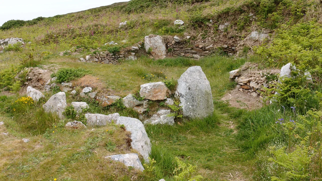
In Welsh they are called Cytiau'r Gwyddelod - the huts of the Irish - a name from a later folk tradition that imagined Irish raiders settling the hill. The reality is older and Welsh. On a level terrace at the southwestern foot of Holyhead Mountain, twenty stone hut circles still stand where they were built, thick-walled, dry-stone, the bases of houses that supported conical thatched or turf roofs propped on poles. Originally there were fifty. The first systematic excavation took place in the 1860s, when William Owen Stanley of Penrhos worked the site with help from Augustus Lane Fox - later better known as the archaeologist Pitt Rivers. Stanley's findings appeared in the 1869 volume of Archaeologia Cambrensis and have anchored the interpretation of the site ever since.
What Survives, and How
Twenty huts of the original fifty are still legible on the ground. Most are circular - the homesteads, the places where families lived - with thick stone walls, hearths set in the floor, alcoves cut into the masonry, and in one case a stone trough still in place. Some huts are oval, divided internally by an interior wall. Others are entered through long stone passages, a feature that hints at colder weather management or simply different functions. The smallest buildings may have been storerooms or workshops. One house at the northeastern end of the terrace has a walled paddock attached, suggesting it kept animals close to the dwelling. None of the roofs survive. They would have been conical, supported by poles set on top of the low stone walls, covered with turf or thatch. The shape is reconstructed from comparisons to other Iron Age round houses across Britain.
Dating an Inhabited Place
The site's chronology is more complicated than 'Iron Age' suggests. Excavators in the early twentieth century found Roman coin hoards and Roman pottery and concluded the huts were Roman-era buildings. Then radiocarbon dating pushed the picture back: the settlement was occupied from late prehistory through the Roman period and possibly into what archaeologists used to call the Dark Ages. Some buildings may have been in use while others were being abandoned. Artefacts recovered include a broken stone axe, flint arrowheads, and pottery fragments from the late Neolithic or early Bronze Age - meaning people were active on this terrace long before the surviving round houses were even built. The site is, in the most literal sense, a palimpsest: layer on layer of habitation, with the visible walls representing only the most recent and the best-preserved layer.
Stanley, Pitt Rivers, and the Victorian Spade
William Owen Stanley was the son of John Stanley, 1st Baron Stanley of Alderley, and inherited Penrhos on the eastern side of Holy Island in 1850. He spent decades digging into Anglesey's prehistoric sites, often with neighbours and visiting antiquarians. Augustus Lane Fox helped him excavate the Ty Mawr huts in 1862 and 1868, before Lane Fox would inherit a different estate, change his name to Pitt Rivers, and become the founder of modern systematic archaeology. The site passed into state guardianship around 1911 and was 'cleared of its artefacts' in 1912-1913, a Victorian practice that would horrify modern archaeologists. Further excavations took place in 1978 and 1982, with much more careful methods, recovering the radiocarbon evidence that rewrote the chronology and the environmental evidence that showed how the surrounding terrace was farmed.
Walking the Terrace Today
The site is in the care of Cadw, the Welsh government's heritage agency. It is open year-round - free to enter, no booking required - except for the three days of Christmas and New Year's Day. Access is up a stone stile over a wall. Stand on the terrace and you have Holyhead Mountain rising sharply behind you, the Irish Sea visible to the west, the modern ferry port of Holyhead just out of sight to the north. The location was chosen for the same reasons settlements anywhere choose hillside terraces: defensible, drained, with views in every direction. The hut walls are about waist-height now, partly because the upper courses have collapsed and partly because the original walls were probably never much taller. People lived here for the better part of a thousand years - through Roman invasion, through Roman withdrawal, through whatever followed - in the same stone houses, on the same terrace, watching the same sea.
From the Air
The hut circles sit on a terrace at the southwestern foot of Holyhead Mountain (722ft), at 53.31N, 4.68W. Look for low circular and oval stone walls arranged on a relatively flat shelf below the mountain proper, near the modern South Stack road. The mountain itself is the prominent terrain feature, rising sharply from the surrounding low ground; the hut circles are on the seaward side. Nearest airfields: RAF Valley (EGOV) 6nm southeast, Caernarfon (EGCK) 22nm southeast. Best viewed at 1,000-2,000ft AGL in clear conditions.
Nearby Stories
- Snowdon Mountain Railway 8 km away
- German submarine U-1051 8.3 km away
- German submarine U-246 11 km away
- Trwyn Du Lighthouse 13 km away
- Irish Sea Bridge 20 km away
- HMS Manners (K568) 34 km away
- HMS Tyler 47 km away
- Birkdale Palace Hotel 79 km away