
Ilemi Triangle
On the map it is a blank wedge of land in the far northwest corner of Lake Turkana, edged by lines that no one ever quite agreed on. The Ilemi Triangle covers about 11,000 square kilometers of hot, sparse rangeland where three nations - Kenya, South Sudan, and Ethiopia - press against one another. It is claimed by two of them, used by the herders of all three, and demarcated by none to everyone's satisfaction. For more than a century, surveyors have drawn red lines, blue lines, and patrol lines across it, and for more than a century the cattle and the people who follow them have crossed those lines as if they were not there.
Lines on Someone Else's Land
The dispute is a colonial inheritance. In 1914, a boundary commission drew a straight parallel to split territories that all belonged to the British Empire anyway - a tidy line on paper that ignored the people on the ground. The Turkana, nomadic herders, had long grazed across the area and kept right on moving as they always had. Today Kenya holds de facto control up to a patrol line that Sudan established in 1950, while the formal claim now sits with South Sudan, inherited from Sudan when South Sudan became independent in 2011. Ethiopia, despite its herders using the land, has never made an official claim, having recognized the territory as Sudanese in treaties dating back to 1902. The name itself may come from the Didinga word Elemi, meaning "acceptance" - said to mark the place where their cattle thrived on the local grass.
The People of the Borderland
Long before any government drew a line here, this was - and remains - the country of pastoralist peoples whose lives are bound to their herds and the search for grass and water. The Turkana graze on the Kenyan side. The Toposa move through the ground between South Sudan and Kenya. The Nyangatom cross between South Sudan and Ethiopia, the Didinga live to the north in South Sudan, and the Dassanech keep to the east in Ethiopia, near the lake. For these communities the triangle is not a diplomatic abstraction but home and pasture, a landscape read in terms of seasons and rainfall rather than national borders. Their claim on the land is the oldest one of all, measured not in treaties but in generations of movement across it.
Cattle, Guns, and Hard Years
Competition over livestock and grazing has long shaped life here, and raiding between groups is an old part of that pattern - but its character changed sharply with history. In earlier times raids were fought with traditional weapons. From the nineteenth century onward, firearms spread through the region, and outside powers made things worse: after the First World War, arms supplied to some groups turned cattle raids into pitched battles in which hundreds could die. In July 1939, during the upheaval of Italy's occupation of Ethiopia, several hundred Turkana were killed in a single raid. These were not abstract casualties. They were herders and families caught in cycles of loss and retaliation that competition over scarce land and water, and the easy availability of guns, made deadlier than ever.
A Century of Indecision
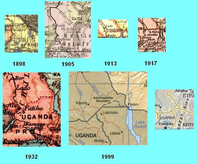
The triangle's modern history reads like a ledger of lines and second thoughts. In 1928 Sudan let Kenyan units cross the border to protect the Turkana, at considerable annual cost. Through the 1930s, survey teams marked a "Red Line" - also called the Wakefield Line - as the northern limit of Turkana grazing; in the 1940s Britain added a "blue line" further northwest; in 1950 Sudan set its own patrol line, explicitly stating it was not an international boundary. Italy briefly claimed the area during its Ethiopian adventure and then let it go. Through all of it, the underlying question of sovereignty was deferred again and again, sidelined by the perceived poverty of the land and by Sudan's long civil wars.
Why It Still Matters
For decades the easiest answer was to leave the question unresolved, and the governments involved largely have, content with an uneasy status quo. But two things keep the triangle from fading entirely from view. One is the recent discovery of oil in the region, which raises the stakes of any future settlement. The other is fiction's strange affection for the place: it is the setting of a 2015 novel, and Marvel Comics located its imaginary nation of Wakanda in roughly this corner of the map. The reality is less glamorous and more human - a stretch of contested grassland where the herders who actually live there continue, as they always have, to follow the rain across borders that exist mainly on paper.
From the Air
The Ilemi Triangle sits at roughly 4.99 degrees N, 35.33 degrees E, the borderland wedge northwest of Lake Turkana where Kenya, South Sudan, and Ethiopia meet. It is flat to gently rolling semi-arid rangeland with few distinct features; the northwest shore of Lake Turkana to the southeast is the most reliable visual anchor. Recommended viewing altitude is 6,000-10,000 feet above ground in the clear, dry, hazy air; ground reference is sparse and navigation by the lake and major dry watercourses is advisable. This is a remote, sensitive border region with essentially no aviation services within the triangle itself; Lokichoggio (HKLK) in northwestern Kenya is the nearest sizeable airfield to the south, with Lodwar (HKLO) farther southeast. Expect extreme heat, strong winds, and dust.
Nearby Stories
- Omo remains 26 km away
- Lake Turkana 79 km away
- Lower Valley of the Omo 97 km away
- Omo National Park 98 km away
- Imatong Mountains 228 km away
- Pibor 251 km away
- Nizhnevartovskavia Flight 544 302 km away