
Khotiv Hillfort
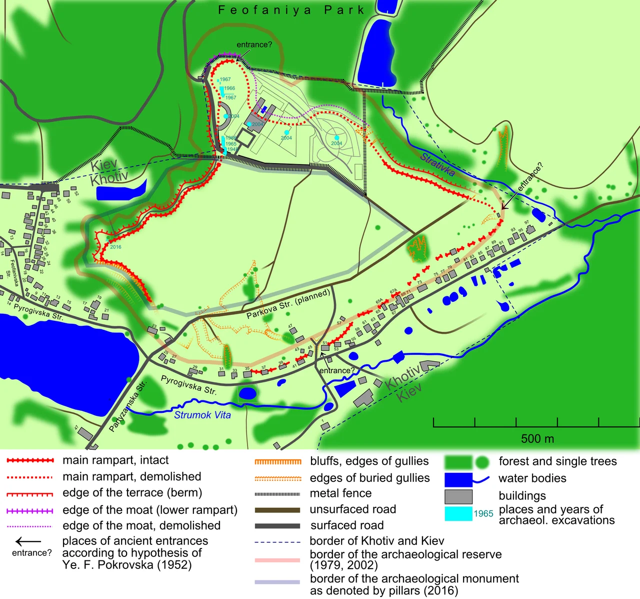
A ring of earth on a plateau south of Kyiv is all that is left, and even that is disappearing. Twenty-five centuries ago, the people archaeologists call the Scythian-age forest-steppe culture raised a great rampart here, enclosing a settlement on high ground above the surrounding land. They built their houses only against the inside of the wall and left the vast center empty, room, perhaps, to shelter cattle when raiders came. For most of its long history the Khotiv hillfort slept under fields and gardens, its rampart softened but intact. Only in the last few decades has that stopped being true, as the modern city has begun to press up against the ancient earthwork and, in places, over it.
A Coin, a Legend, a Dig
The hillfort surrendered its secrets slowly. Local historians noted it in the nineteenth century and passed along a legend of an ancient town ruled by a prince named Siriak, a name still attached to the surrounding locality and recorded as far back as 1465, though modern archaeology found no castle to match the tale. The real evidence surfaced almost by accident. In 1917, someone on a botanical excursion picked up a bronze coin from the Greek city of Corinth, struck in the fifth century BC. The next year brought fragments of Scythian pottery and later Slavic objects. Systematic excavation began in 1948 and continued through the 1960s, then resumed with magnetic surveys in the 2000s that mapped buried buildings without disturbing the soil. Piece by piece, a picture emerged of a substantial, long-lived community on this windswept plateau.
Traders of the Steppe
The people of Khotiv were not wanderers. The finds describe a settled community that farmed, raised animals, and bred horses especially, with hunting playing a large role in daily life. They built long houses, some more than twenty meters, of wood packed with clay, and left behind a scatter of ordinary life: spindle whorls for spinning thread, a fishing sinker, small clay balls and loaves that may have been offerings, a bone tool handle, beads of lead and yellow glass. Bronze rings and arrowheads and iron knives came out of the ground. And among the local pottery lay Greek pottery, traced to the islands of Chios, Lesbos, Samos and the town of Klazomenai, proof that goods moved between this inland plateau and the distant Greek colonies of the Black Sea coast, if less freely here than at hillforts closer to the trade routes.
A Monument Under Pressure
The plateau's later owners tell their own story of Kyiv. In 1588 a prince transferred the site to the Kyiv Pechersk Lavra, and it stayed monastic land for nearly two hundred years, until Catherine the Great's secularization reforms handed it to the villagers of Khotiv in 1786. From then it was simply farmland and gardens, the rampart a quiet feature of the countryside. The state recognized its importance, naming it an archaeological monument in 1965 and a site of national significance in 2001. Yet the protected boundaries have been redrawn and shrunk more than once, and land excluded from protection has been sold, split, and built upon. A large private residence rose on the richest northern part of the hillfort, and roads and parcels have encroached from other sides. Today red concrete pillars mark the reduced area still under protection, and much of what remains is planned to become a museum, a monument fighting to keep its ground.
Reading the Ground
To stand on the Khotiv plateau today is to read a landscape rather than a ruin. There is no reconstructed gate here, no signposted tower, only the long swell of the ancient rampart and the drop of the scarp beneath it, the shape of a fortification that predates the city of Kyiv by centuries. From the western edge the view opens across the surrounding country, and it takes an effort of imagination to repopulate the empty plateau with its long clay-and-timber houses ranged against the inner wall, its horses and its traders' Greek jars. The archaeologists have done much of that imagining for us, mapping buried buildings with magnetic instruments and marking the boundaries with stones and plaques. What survives is fragile and quiet, the kind of monument that asks the visitor to slow down and look, to see in a ridge of earth the outline of a community that farmed this high ground, bred its horses, and traded with the distant islands of the Aegean twenty-five centuries ago.
From the Air
The Khotiv hillfort sits at 50.3336 N, 30.4878 E on a plateau south of Kyiv, near the village of Khotiv and Feofaniya Park. From about 2,000 feet AGL, look for the raised, roughly oval plateau ringed by the faint line of an ancient rampart and scarp, now partly bordered by roads and new construction, with St. Panteleimon's Cathedral visible toward the horizon. Nearest airport is Kyiv International (Zhuliany), ICAO UKKK, to the north; Boryspil International, UKBB, lies to the northeast.
Nearby Stories
- Boryspil 1.5 km away
- Zalissia National Nature Park 31 km away
- Trakhtemyriv 32 km away
- Bila Tserkva 40 km away
- Malyn 46 km away
- Radomysl Castle 49 km away
- Nizhyn 81 km away
- Berdychiv 95 km away