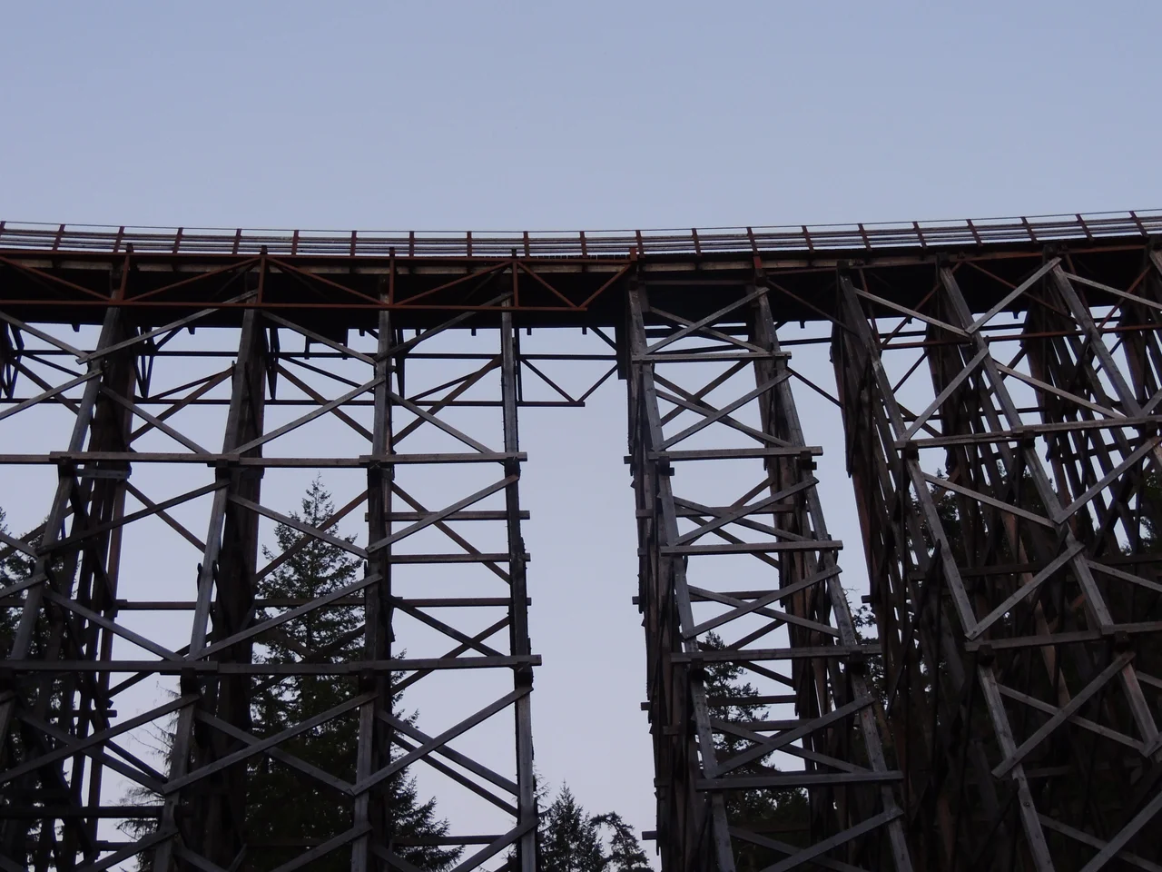

Kinsol Trestle
The mine it is named for produced three rail cars' worth of ore. Between 1924 and 1927, the King Solomon Mines - a name that promised rather more than it delivered - pulled 254 tonnes of rock out of the ground near the Koksilah River, yielding about 18 tonnes of copper and roughly six kilograms of silver before the venture gave up. A nearby railway stop took the shortened name Kinsol, and the enormous wooden bridge beside it inherited it. The trestle has nothing to do with mining. It was never built to serve those workings, despite a persistent local belief otherwise. It stands 44 metres above the river and runs 188 metres across - the largest wooden trestle in the Commonwealth of Nations and among the tallest railway trestles anywhere - and it is named after one of the least productive holes ever dug on Vancouver Island.
A Railway to Nootka Sound
The real ambition was timber. By 1911 logging had taken hold on Vancouver Island, and moving old-growth trees to tidewater by oxen and skid road had become the bottleneck. The Canadian Northern Pacific Railway began pushing a line intended to run from Victoria through Cowichan Lake and Port Alberni all the way to Nootka Sound on the island's outer coast. Engineers designed the crossing at the Koksilah. Local farmers and loggers built it, financed in part by the Canadian Western Lumber Company - at that moment the largest lumber company in the world. Then the money and the moment ran out. The CNoPR never finished the trestle, and the line got no further than Youbou. Canadian National Railways absorbed the company in 1918 and completed both the line and the bridge in 1920, roughly a decade after the first survey stakes went in.
Curved Timber
What makes the Kinsol unusual among big trestles is that it does not go straight. The structure carries a seven-degree curve across its entire span, a demanding piece of geometry to execute in wood, where every bent must be set and braced to follow an arc rather than a line. The material was old-growth Douglas fir, cut from forests that were still standing in quantity when the bridge went up and are now largely gone - timbers of a dimension and density that a modern builder simply cannot source. Standing beneath it on the riverbank, the thing reads less like a bridge than like a piece of forest rearranged: a lattice of dark beams forty-four metres tall, with daylight coming through in slats and the Koksilah running underneath.
The Argument Over Demolition
Canadian National abandoned its Vancouver Island rail service in the 1980s, and the right of way passed to the provincial Ministry of Transportation. The trestle then spent two decades rotting. By the 2000s it was closed to walkers and cyclists, flagged as both an environmental liability and a public danger, and seriously proposed for demolition. That split the Cowichan Valley. One camp wanted the structure preserved for its history and its tourism value; another simply wanted the gap in the Trans-Canada Trail closed as cheaply as possible, since crossing the Koksilah on foot then required an 8.5-kilometre detour through rough ground. Both positions were reasonable. The Cowichan Valley Regional District called a special meeting on 7 June 2007 to settle it.
Eighty Percent Sound
At that meeting, a timber-framing firm from nearby Cobble Hill made an unexpected case. Macdonald & Lawrence was local in address and decidedly not local in reputation - a company that had built unusual structures across Britain, received a commendation from Queen Elizabeth for its work restoring Windsor Castle after the 1992 fire, and was engaged in stabilizing Shackleton's hut in Antarctica. They proposed full conservation for pedestrian use rather than replacement. In November 2007 they drilled hundreds of test holes through the trestle's members and reported a number that changed the conversation: 80 percent of the major timbers were still sound. The bridge was not a ruin. It was a repairable structure that happened to look like a ruin, and the difference was worth several million dollars.
Five Point Seven Million
The regional district voted overwhelmingly to proceed, commissioning Commonwealth Historic Resource Management with Macdonald & Lawrence to deliver a full restoration plan, which arrived in November 2008. Public money covered part of the roughly $5.7 million cost; a community campaign launched on 10 June 2009, backed by the Cowichan Foundation and the regional district, raised the remaining $2 million from people who mostly just wanted to be able to walk across. The Kinsol Trestle reopened on 28 July 2011. It now carries the Trans-Canada Trail and the Vancouver Island Trail across the Koksilah River, which means the bridge finally does what it was built for - moving people through this valley - even if the freight it was designed to carry stopped running forty years ago.
From the Air
The Kinsol Trestle crosses the Koksilah River at 48.668 N, 123.694 W, about 8 km north of Shawnigan Lake in the Cowichan Valley of southern Vancouver Island. A viewing altitude of 1,500-3,000 feet MSL is best - the trestle is 188 m long and 44 m high, showing from the air as a distinctive dark, slightly curved line crossing a forested river gorge, with the cleared former rail grade running away from both ends. Shawnigan Lake is the primary landmark to the south, Cowichan Bay and Duncan lie north, and the Malahat ridge rises to the east between here and the Saanich Inlet. Terrain is rolling forested hill country, so maintain clearance. Duncan Airport (CAM3) is about 10 nm north, Victoria International (CYYJ) roughly 25 nm southeast, and Nanaimo (CYCD) some 30 nm north. Expect low cloud and rain from autumn through spring; the gorge holds morning fog, and the structure is much easier to pick out once the sun is high enough to light the span.
Nearby Stories
- Yellow Island 1.7 km away
- Scia'new First Nation 2.5 km away
- San Juan Spruce 6.5 km away
- Kolponomos 8.5 km away
- Wallace Island Marine Provincial Park 8.6 km away
- Cowichan Lake 12 km away
- Lily Point Marine Reserve 12 km away
- Smith Island (Washington) 15 km away