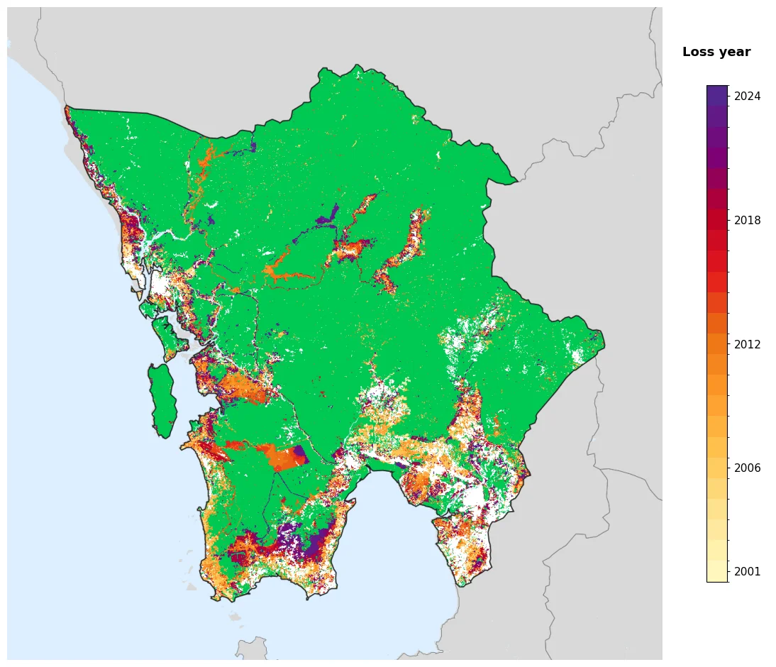

Koh Kong province
In 1907, France gave a province back. Trat, on the eastern rim of the Gulf of Thailand, had spent three years under French Indochina before returning to Siam in a swap that traded one stretch of coast for another. Koh Kong stayed. The boundary that had run through these waters since 1795 hardened into an international border, and the province on the Cambodian side of it has been negotiating with that fact ever since - looking east to Phnom Penh for its government and west to Thailand for its market. Ten thousand square kilometres of mangrove, mountain and rain, and for most of the twentieth century the easiest way in was by boat from somebody else's country.
The Coast That Changed Hands
From 1795 the coast was administered from Bangkok, and during the reign of King Mongkut it acquired a Siamese name - Patchan Khiri Khet - chosen as a deliberate mirror to Prachuap Khiri Khan, the town sitting on the same latitude across the gulf. Renaming is the sort of thing empires do when they want a map to look symmetrical. In 1904 the region and the city of Trat passed to French Indochina in exchange for the withdrawal of French troops from Chanthaburi. Three years later the deal was rewritten: Trat went back to Siam, the Siamese province of Inner Cambodia came to France, and Koh Kong remained French Cambodian. None of the people living on this coast were asked. The name that survived all of it was the one they had used the whole time.
A Maze of Bays and Channels
Where the province meets the sea, the land stops being reliably land. Peam Krasop Wildlife Sanctuary, established in 1993, covers 246 square kilometres of islands separated by tidal channels, with roughly 23,750 hectares of mangrove threaded through them - a Ramsar-listed wetland that about ten thousand people call home. At Boeng Kayak a kilometre-long boardwalk runs out over the roots on stilts, ending at a fifteen-metre tower where the mangrove canopy resolves into an unbroken green plain cut by silver water. A survey reported in 2024 counted around seven hundred species living in these mangroves. The same forest is also charcoal, and shrimp ponds, and firewood: the pressure on it is not abstract, and it comes mostly from people with few alternatives.
Empty, Then Full
After the Khmer Rouge regime fell in 1979, Koh Kong was close to empty - a province of forest and coast with almost nobody in it. The national government encouraged Cambodians to settle here, and they came, from other provinces and from the border trade. The 2024 census counted 140,962 people spread across 10,090 square kilometres, about twelve to the square kilometre, which sounds like nothing until you remember that most of the interior holds nobody at all. Roads arrived late. The first bridges went up in 2002; the 1,900-metre Koh Kong Bridge, Cambodia's second-longest after the Neak Loeung crossing opened in 2015, links the provincial town toward the Thai frontier at Cham Yeam, fourteen kilometres away. National Route 48 was sealed through to Sre Ambel in 2007, and four Thai-funded bridges along it opened in May 2008.
The Runway Nobody Needed
In 2008 a Chinese firm, Union Development Group, took a ninety-nine-year lease on 360 square kilometres of the Botum Sakor coast - close to a fifth of Cambodia's entire shoreline - for a development called Dara Sakor: casinos, golf courses, resorts, a deep-water port. It also built a concrete runway more than three kilometres long, longer than a province of 140,000 people has any commercial use for, with turning bays too tight for large civilian aircraft. Analysts drew the obvious conclusion. In September 2020 the US Treasury sanctioned UDG over corruption and land seizures; the State Department has said the strip could handle Chinese military aircraft. More than a thousand families were displaced, and in October 2021 hundreds of them rejected a compensation scheme run as a lottery. Hun Sen denied any military purpose, noting that Cambodia's constitution has no provision for foreign bases on its soil. The airport, VDDS, began domestic flights in late 2024.
The Interior Nobody Crosses
Behind the resorts, Botum Sakor National Park covers 1,826 square kilometres of coastal forest declared in 1993, home to more than forty mammal species including clouded leopards, fishing cats and a population of pileated gibbons that may represent a tenth of the world's remaining animals. Seven economic land concessions have been carved from inside its boundaries, together amounting to roughly seventy percent of the park. Push further inland and the concessions run out because the terrain does. Central Cardamom Mountains National Park - 4,011 square kilometres, protected as forest from 1999 and elevated to national park in 2016 - climbs across Koh Kong into Pursat and Kampong Speu, where the western slopes catch between 3,800 and 5,000 millimetres of rain a year. There are districts here, Thma Bang among them, where the road simply stops and the forest keeps going.
From the Air
Koh Kong province centres near 11.40°N, 103.49°E, occupying Cambodia's southwestern corner between the Gulf of Thailand and the Cardamom Mountains. Best viewing altitude is 6,000-10,000 ft along the coast, where the mangrove archipelago of Peam Krasop reads as a green labyrinth of islands and tidal creeks, and the 1,900-metre Koh Kong Bridge is a clean straight line across the estuary. Inland the terrain rises quickly into forested ridges with no roads and few landmarks - treat the interior as remote and plan accordingly. Nearest airports: Dara Sakor International (VDDS/DSY) on the Botum Sakor coast, Sihanouk International (VDSV/KOS) to the southeast, Phnom Penh International (VDPP/PNH), and Trat (VTBO/TDX) across the Thai border. The old Koh Kong airstrip (VDKK) is abandoned. The southwest monsoon runs roughly May to October and the Cardamom windward slopes are among the wettest places in Cambodia; expect low cloud, heavy convective build-ups and rapidly closing visibility over the ranges.
Nearby Stories
- Koh Kong Island 1 km away
- Cheay Areng Dam 3.2 km away
- Koh Kong 3.7 km away
- Cambodian campaign 16 km away
- Dara Sakor International Airport 38 km away
- Kampot 54 km away
- Koh Poulo Wai 129 km away
- Boeng Tonle Chhmar 137 km away