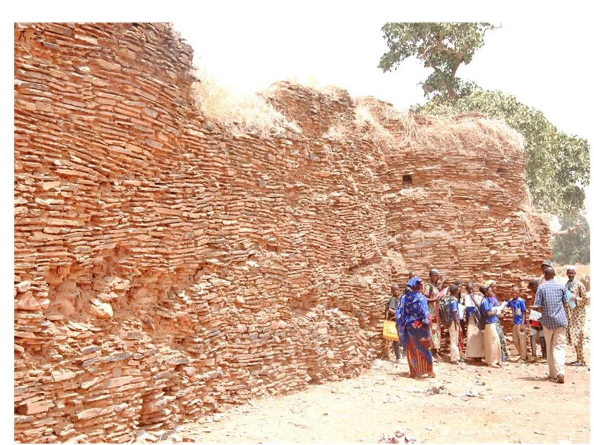

Koniakary Tata
Buna Ndiaye had a province to defend and three years to do it. The engineer set his crews to quarrying flat stone from the ground beneath their feet, and by January 1857 a rectangle of rock rose out of the western Malian bush at Koniakary - 115 meters on its longest side, six meters tall, walls two meters thick at the base, eight towers watching the horizon. This was a tata, the fortified enclosure of the Sahel, and its builder served one of the most formidable figures of nineteenth-century West Africa: El Hadj Umar Tall, founder of the Toucouleur Empire.
A Wall Against the Coming Storm
The tata was not built for show. Umar Tall's empire stretched across the upper Senegal and Niger watersheds, and Koniakary guarded the province of Jambukhu, the empire's western flank, exactly where French ambition was pressing inland from the coast. Buna Ndiaye, the engineer credited with the work, began construction in 1854 - though the fortress is sometimes mistakenly attributed to Samba Ndiaye, another of Umar Tall's master builders. Stone was the unusual choice here. Many tatas of the region were earthen, packed mud rising in smooth ramparts, but Koniakary's defenders quarried flat stone directly from the site and laid it up into something meant to outlast a siege. For a generation, it did exactly that.
The Day the Guns Came
The reckoning arrived on June 15, 1890. Colonel Louis Archinard, the French officer who spent the decade methodically dismantling the Toucouleur state, turned his artillery on Koniakary and destroyed the tata. The fall was not an end in itself but a beginning: the French expedition that would seize Nioro du Sahel set out only after Koniakary's walls had come down, the fortress serving as the gate that had to be broken before the deeper conquest could proceed. Within months the western Sahel that Umar Tall and his sons had ruled was passing, province by province, into French hands. The empire that built the tata did not outlive the century.
What the Stones Still Say
More than a hundred and twenty years later, the defensive wall is still visible - a long broken line of quarried stone tracing the rectangle Buna Ndiaye laid out, weathered and breached but stubbornly present. Mali recognized what it held. In November 2011, the country's Council of Ministers adopted a decree classifying the Koniakary tata as part of the national cultural patrimony, formal acknowledgment that these ruins are not merely old stones but a monument to resistance. To stand among them is to read a single sentence of history written in rock: a wall raised in hope, held for a generation, and broken in an afternoon - and yet refusing, even now, to disappear.
From the Air
The Koniakary tata sits at 14.58°N, 10.90°W in Mali's Kayes Region, near the town of Koniakary northeast of Kayes city. The nearest airfield is Kayes Dag Dag Airport (GAKY), roughly 50 km to the southwest; Bamako-Sénou International (GABS) lies far to the east-southeast. The flat stone rectangle and surviving wall line are best picked out from a low pass in the dry season, when the savannah is bare and the ruin stands clear of vegetation. Skies in the Sahel are typically cloudless and dust-hazed; visibility is best in the cooler months before the harmattan thickens.
Nearby Stories
- Gouina Falls 25 km away
- Nioro du Sahel 117 km away
- Manantali Dam 117 km away
- Boucle du Baoulé National Park 185 km away
- Aoudaghost 304 km away
- Brakna region 355 km away
- Fugumba 379 km away
- Battle of Porédaka 422 km away