La Rumorosa
La Rumorosa sits at 4,193 feet in the Sierra de Juárez, on the Baja California side of the border that separates it from Jacumba Hot Springs, California — a town visible from the ridgeline but unreachable by road without a crossing several miles away. The name means 'the murmuring one,' which might refer to the wind through the pines, or the sound of the mountain, or something the original namers heard and understood in a way that translation cannot fully recover. The road down from La Rumorosa to the desert floor below has been called one of the most dangerous in Mexico. People drive it anyway, because it is the only road.
On the Escarpment Edge
The Sierra de Juárez forms the eastern escarpment of the Baja California peninsula, rising abruptly from the desert of the Mexicali Valley. La Rumorosa occupies a position near the top of this escarpment, at an elevation that brings pine trees and cooler temperatures to a region otherwise defined by desert heat. The town has a population of approximately 1,836 people — a permanent community sustained by the highway and by the modest tourism that the climate and the landscape attract.
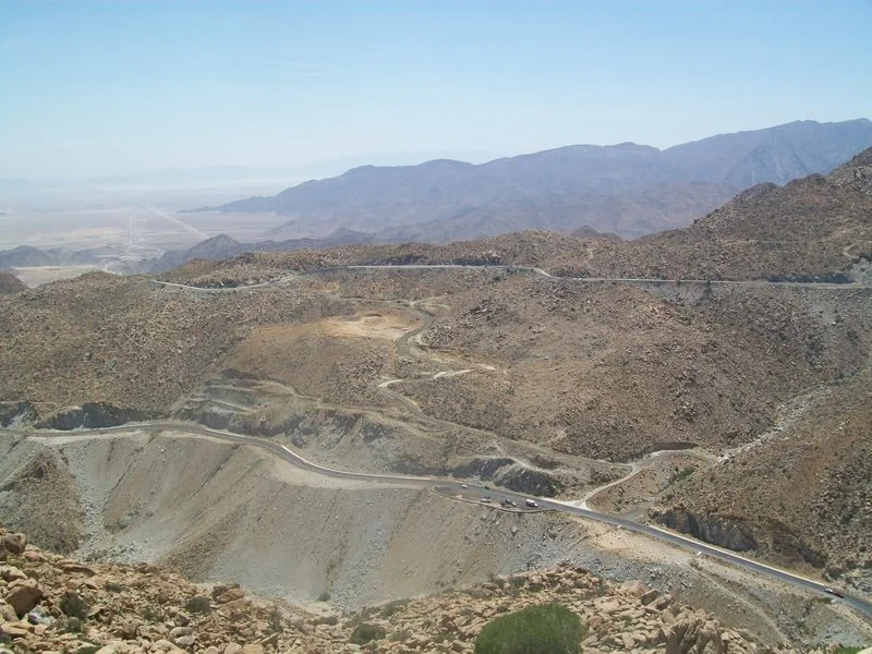
From La Rumorosa, the view eastward toward the Mexicali Valley and the Colorado River delta takes in one of the more dramatic elevation changes in North America — several thousand feet of descent in a very short horizontal distance. The escarpment that makes this view possible also creates the road problem that La Rumorosa is known for.
Mexican Federal Highway 2D
The road connecting La Rumorosa to the desert floor below was completed in 1917, following a route through the escarpment that engineers found workable but that physics made inherently treacherous. Mexican Federal Highway 2D descends from La Rumorosa through a series of switchbacks and steep grades that have claimed vehicles and lives for more than a century.
The road's reputation extends throughout northern Baja California. Truck drivers who must carry freight between the coast and the interior navigate it carefully; the combination of steep grade, tight curves, and unpredictable weather — fog can settle on the escarpment with little warning — makes the descent demanding for experienced drivers and genuinely dangerous for the inattentive. The highway has been improved over the decades, but the escarpment has not moved.
El Vallecito and the Older Road
A few miles from La Rumorosa, in the Sierra de Juárez, is El Vallecito — a Kumeyaay archaeological site with rock art dating to approximately 8000 BCE. The site includes multiple feature areas with paintings and engravings, mortars and metates, evidence of sustained use as a seasonal camp and ceremonial space over thousands of years.
The most remarkable feature is a winter solstice alignment: on December 21 and 22, a ray of sunlight enters a rock shelter and illuminates the eyes of a painted figure for a few minutes. The precision required to build such an alignment — sustained astronomical observation over many years, then construction oriented to exploit that knowledge — is evidence of sophisticated engagement with the sky that predates the road, the border, and the town above it by millennia.
The site is managed by Mexico's Instituto Nacional de Antropología e Historia and is accessible from Federal Highway 2. Every year the solstice light still falls on the painted eyes, as it was designed to do.
Across the Ridge from Jacumba
There is no direct road crossing between La Rumorosa and Jacumba Hot Springs, though the two towns are separated by only a few miles of mountain ridge. To travel between them legally requires driving east to Tecate or west to other crossing points — a detour of many miles for towns that can see into each other's territory.
The border that separates them was drawn in 1848 through Kumeyaay homeland without the knowledge or consent of the people who lived there. La Rumorosa sits in Tecate Municipality, administratively connected to the Pacific coast cities of Baja California. Jacumba sits in San Diego County, administratively connected to the coast of California. The ridge between them has no opinion on any of this.
From the Air
La Rumorosa is located at approximately 32.523°N, 116.059°W at 4,193 feet elevation in the Sierra de Juárez, Tecate Municipality, Baja California, Mexico. The escarpment drop toward the Mexicali Valley is dramatic and visible from altitude. The town is directly south of the US-Mexico border and east of El Vallecito. Nearest airports: KSAN (San Diego International, ~55 nm NW), TIJ (Tijuana International, ~40 nm W), KIPL (Imperial, ~45 nm NE).
Nearby Stories
- Mud Caves of Anza-Borrego 6 km away
- Capitan Grande Reservation 6.2 km away
- Mount Signal Solar 7.7 km away
- Brawley, California 17 km away
- Jamul Indian Village 18 km away
- Spanish Missions in Baja California 23 km away
- Off-roading in Baja 145 km away
- San Felipe 250 195 km away