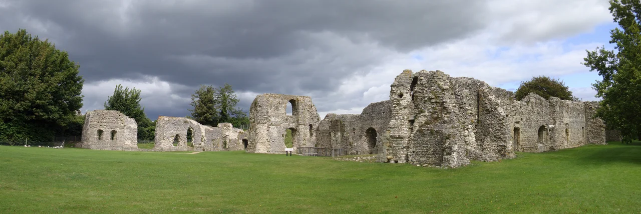

Lewes Priory
Thomas Cromwell hired an Italian engineer to make sure nothing remained. In 1538, Giovanni Portinari arrived at Lewes Priory with a specialist demolition crew and a careful brief: not just to seize the monastery from its monks but to obliterate it. He kept records. He pulled down the central tower with explosives, sent men in to topple the nave, and burned what would burn. The priory church of St Pancras had stood 128 metres from west door to apse, taller than Chichester Cathedral, its great vault nearly thirty metres above the floor, decorated with the finest figurative carving in southern England. By the time Portinari was finished, almost nothing rose above the cellars. What was once the largest church in Sussex is now a low ridge of overgrown stone in a public park.
A Norman Statement
William de Warenne, 1st Earl of Surrey, founded the priory in about 1081 with his wife Gundrada. They had visited the great motherhouse of Cluny in Burgundy four years earlier and returned wanting something of its ambition here in Sussex. The site they chose - a low spur at the head of the tidal Ouse valley, south of Lewes town - already held a Saxon shrine to St Pancras, a Roman boy-martyr whose cult linked England and Rome. The pre-existing dedication was kept. The new church, however, was something else entirely. Modelled on Cluny III, then the largest church in Christendom, Lewes Priory was meant to assert that the Norman conquest of England was permanent, sacred and absolutely legitimate. A Cluniac Pope, Gregory VII, was on the throne of St Peter. A Cluniac priory rising at the southern landing of England put the new regime in continuity with Rome itself.
Within the Walls
The precinct enclosed sixteen hectares - comparable in size to the walled town of Lewes on the ridge above. High flint walls ran around the whole, broken by the Great Gate that opened toward Southover. Inside, fifty monks at any one time prayed the Cluniac offices through long days and longer nights, while lay brothers ran the bakeries, fish ponds, dovecote and watermills. The priory had its own quarries: first Quarr limestone shipped up the Ouse from the Isle of Wight, then in the 12th century Caen stone imported from Normandy along with Sussex marble for the finer detailing. There was a school of sacred painters who worked across the county, a mason's yard, a glazed-tile manufactory. The figurative carvings that survive at the British Museum suggest a level of artistic sophistication few other English Cluniac houses ever matched.
A King at the Gate
In May 1264, Henry III sheltered behind the priory walls after his army was broken on the slopes above Lewes by Simon de Montfort. The Battle of Lewes was one of the formative engagements of the Second Barons' War, and when the king's forces collapsed Henry retreated to the only fortified position he could reach - the Cluniac precinct. De Montfort's men attacked. The result was the Mise of Lewes, a peace forced on a defeated king that obliged him to accept a council of barons and elected commoners. Historians still argue whether this counts as the first parliament in any meaningful sense, but the moment when a king signed a parchment under duress inside the walls of Lewes Priory is a marker on the long road toward something like representative government in England.
The Dissolution
Lewes surrendered to the Crown on 16 November 1537, one of the first and grandest of the larger monasteries to fall in Henry VIII's dissolution. Cromwell did not wait. Portinari's destruction team set about pulling the church down stone by stone. The lead from the roofs went to the Crown. Cromwell himself was granted the manor of Southover and the site of the dissolved priory in 1538, and built a fine new house - "the Lord's Place" - on top of the prior's lodgings. After Cromwell's own execution in 1540 the property passed to Anne of Cleves, and after her death to the Sackville Earls of Dorset. The priory's vast church became a quarry for centuries; ashlar that had once vaulted thirty metres above singing monks now lines garden walls in Southover. Even now you can identify priory stone in walks around Lewes.
Bones in Lead Cists
In 1845, navvies from the Brighton, Lewes and Hastings Railway cut a new line straight through the priory site. They were digging in what had been the chapter house when they struck two lead cists - small, sealed lead coffers - holding the bones of William de Warenne and Gundrada herself, undisturbed since 1088 and 1085 respectively. The cists were carefully removed and the bones moved to the neo-Norman south chapel of St John the Baptist Southover, the parish church that had once been the priory's hospitium. Gundrada's original black Tournai marble tombstone, carved with her name in Latin and recovered from another parish where it had been re-used, lies beside them. The railway navvies, less reverentially, sold the loose bones, teeth and skulls they exhumed during nearby foundation work. A substantial protected ruin of the lesser priory buildings still stands in a public park south of the railway line. The infirmary chapel walls survive to about a metre. A recreated medieval herb garden grows on the original cloister terrace. An apple orchard holds six rare old Sussex varieties. A large metal sculpture of a knight's helm, raised in 1964, marks the Battle of Lewes. Almost nothing of the great church remains.
From the Air
Located at 50.87°N, 0.01°E, immediately south-west of Lewes town centre. The site appears as a green oval roughly 500 metres east-west, bisected by the Brighton-to-Eastbourne railway line. The conical earth mound known as the Mount (15 m high, 46 m diameter) stands at the east edge of the precinct and is the most visible feature from the air. Nearest airfield is Shoreham/Brighton City (EGKA) about 23 km west. Best viewed at 1,500-3,000 ft AGL; the Castle of Lewes on the ridge to the north makes a useful orientation marker.
Nearby Stories
- Chiddingstone Castle 4.4 km away
- Kent 4.6 km away
- Camber Castle 5.4 km away
- Surrey 13 km away
- Amberley Museum & Heritage Centre 13 km away
- Swanage Lifeboat Station 113 km away
- Le Paradis Massacre 137 km away
- Wellington Clock Tower 150 km away