
Loudoun County, Virginia
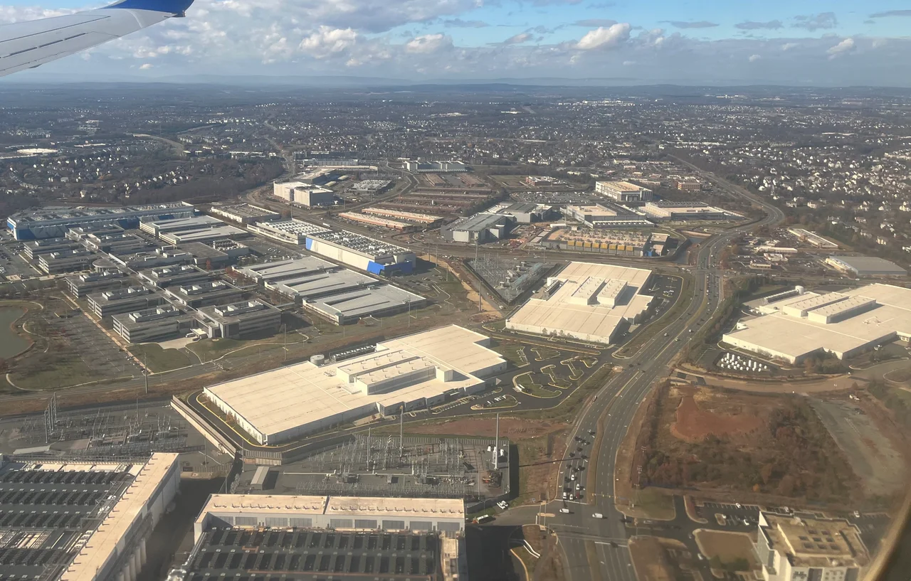
If you open a browser anywhere on Earth right now, your packets probably travel through a cornfield in Loudoun County. Inside the windowless boxes scattered along Route 28 in Ashburn, more than sixty data centers process what local boosters call Data Center Alley - some 25 million square feet of server capacity that handles, by one disputed estimate, 70 percent of daily global web traffic. The fields outside still grow corn and host horse trials. The cattle still graze near Middleburg. But the dominant export of this Virginia county is no longer wheat. It is bandwidth. The transition happened so quickly that the people who broke ground on Dulles Airport in 1958 - when Loudoun was still considered the breadbasket of Virginia - would not recognize the skyline of cooling towers and chain-link that has grown up around it.
Breadbasket of the Revolution
Loudoun County was established in 1757 from the western half of Fairfax County. It took its name from John Campbell, Fourth Earl of Loudoun and governor general of Virginia from 1756 to 1759. By the time of the American Revolution it was the most populous county in Virginia, and its rolling Piedmont produced so much grain for the Continental Army that George Washington's commissaries called it the Breadbasket of the Revolution. The First Families of Virginia - Carters, Lees, Masons - laid out plantations across the eastern half. The western half drew a different population: German and English Quakers fleeing the slave economy further east, who established farming villages around Waterford, Hillsboro, and Lincoln. This was unusual for Virginia. The split would matter eighty years later when the Civil War arrived and the western Quaker villages stayed loyal to the Union while the eastern plantations seceded with the Confederacy. The county was at war with itself before the larger war began.
Mosby's Country
Both Loudoun delegates voted against secession at the Virginia convention in April 1861. John Janney, a former Quaker and former slaveholder from Leesburg, presided over the convention itself. The voters of Loudoun then ratified secession anyway. By October the war had come to Ball's Bluff, where a young first lieutenant named Oliver Wendell Holmes Jr. - the future Supreme Court justice - took a Confederate bullet through the chest and survived. Throughout 1863 and 1864 the rolling country between Aldie and the Blue Ridge belonged to Colonel John Singleton Mosby and his 43rd Battalion Virginia Cavalry. The locals called the area Mosby's Confederacy. His Rangers slept in farmhouses by day and rode out at dusk to ambush Federal patrols on the turnpikes, then vanished back into the civilian population by dawn. The Union army never captured him. Stuart's cavalry fought through the Loudoun Valley in June 1863 covering Lee's march to Gettysburg - at Aldie, at Middleburg, at Upperville. After the war the German Quaker villages in the west and the plantation towns in the east took decades to speak to each other again.
Dulles Changes Everything
On November 17, 1962, President Kennedy dedicated Dulles International Airport on a stretch of corn and pasture in southeastern Loudoun. Eero Saarinen had designed the terminal: a sweeping concrete shell that looked like nothing else in America. Saarinen did not live to see it open. The airport was named for John Foster Dulles, Eisenhower's Secretary of State, who had also been dead by the time construction began. For the first decade the airport was an underused white elephant - too far from Washington, too expensive to reach. Then the high-tech corridor along the Dulles Toll Road began to grow eastward from Tysons Corner, the federal contracting firms followed, and by the late 1990s Loudoun was the fastest-growing county in the United States. AOL set up headquarters in Dulles in 1996. Verizon Business followed. MCI moved to Ashburn in 2003. The planned communities - Sterling Park, Ashburn Village, Brambleton, Stone Ridge - swallowed farms by the thousand acres. The county population went from 57,427 in 1980 to 420,000 in 2020.
The Internet Capital
In the late 1990s a regional internet exchange called MAE-East operated out of a Tysons Corner parking garage. When that exchange ran out of room, the engineers running it began looking for cheap real estate with cheap power, low seismic risk, and proximity to the federal government. Eastern Loudoun met all three criteria. The first Equinix data center opened in Ashburn in 2000. Amazon Web Services located its us-east-1 region here a few years later. AWS us-east-1 is the largest single concentration of cloud computing on Earth. When it goes down, half the consumer internet goes down with it. The county collects roughly $700 million a year in tax revenue from data centers, more than any other source. Residents have begun to push back against the visual and environmental impact - the cooling towers, the diesel backup generators, the substations the size of small malls - and the county has tightened zoning. But the corridor keeps growing. Loudoun is now the wealthiest county in the United States by median household income, at $156,821 a year as of 2023.
Horse Country, Wine Country
Drive west from Ashburn for thirty minutes and the data centers disappear. The Loudoun Valley opens up between the Catoctin and Bull Run mountains, with the Blue Ridge rising blue and gray on the far side. The equine industry generates around $78 million a year. The Morven Park International Equestrian Center near Leesburg hosts national horse trials on grounds that once belonged to a Virginia governor. More than forty wineries now operate in the western county - the soil, drainage, and elevation produce respectable Cabernet Franc and Petit Verdot, and the wineries serve as weekend destinations for the Washington urban professionals who increasingly cannot afford to live in the county where they drink. James Monroe spent the last decade of his life at Oak Hill Plantation south of Leesburg, treating it as a primary residence between 1823 and his death on July 4, 1831 - the third president to die on Independence Day. The county motto, I Byde My Time, comes from the coat of arms of the Earl of Loudoun. It has aged well. Loudoun has been waiting since 1757. It is finally getting noticed.
From the Air
Loudoun County spans roughly from 38.95 to 39.32 degrees N and from 77.34 to 77.95 degrees W, bordered by the Potomac River to the north, the Blue Ridge to the west, and Fairfax County to the east. From 4,500 to 6,500 feet AGL the contrast between the data-center corridor along Route 28 and the rolling western horse country shows clearly. Dulles International (KIAD) dominates the eastern end. Other airports include Leesburg Executive (KJYO) and Manassas Regional (KHEF) just south. The entire eastern half lies inside Class B airspace - coordinate with Potomac TRACON. Watch for P-40 over Camp David north of the river and P-56 over Washington to the southeast.
Nearby Stories
- The Stone House, Manassas National Battlefield Park 3.3 km away
- Long Branch Plantation 7.7 km away
- Surratt House Museum 12 km away
- National Archives at College Park 13 km away
- The Inn at Little Washington 18 km away
- Antietam: The Day America Lost 23,000 Men 22 km away
- Gravity Hill 84 km away
- Three Mile Island 89 km away