Lukanga Swamp
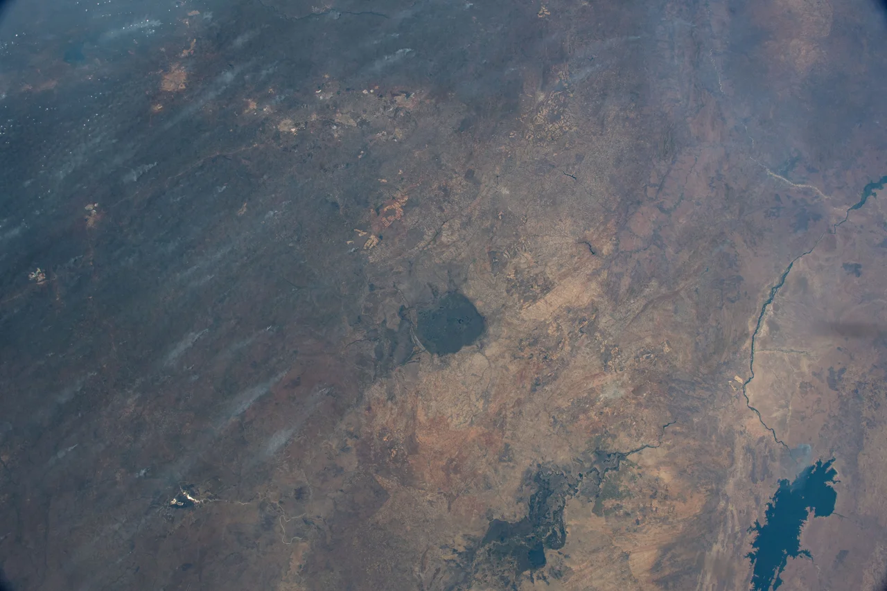
From orbit it looks almost suspiciously round. A dark disc of wetland roughly 40 to 50 kilometres across, ringed by dryland and threaded with the slow, glinting lines of rivers, sitting just west of Kabwe in central Zambia. For a while some researchers wondered whether Lukanga Swamp was an astrobleme, the scar of a meteorite impact. Fieldwork in 2002 found no shocked rocks to support that idea. The truth is stranger: no one knows exactly why it is here, or how it formed. What is certain is that it is alive, and that papyrus covers most of it.
An Inland Sea of Papyrus
The permanently swampy core of Lukanga covers roughly 1,850 square kilometres. Add in the river mouths that feed it, particularly the Lukanga River arriving from the northeast, and another 250 square kilometres of flooded channels. Throw in the Kafue River floodplains along its western and northwestern edge, and the whole wetland system reaches about 2,600 square kilometres. From above, in NASA imagery, the swamp reveals a two-toned pattern: dark spots where lagoons like Lake Chiposhye and Lake Suye break through the vegetation, and green-black expanses where thick papyrus covers the water entirely. Near the Kafue channels, the papyrus thins and the swamps read darker still. The wetland sits within the Zambezian flooded grasslands, one of the great seasonal ecosystems of southern Africa.
The Fish Come and Go
Fishing is the livelihood here, and it fluctuates with the rains. Older estimates put catches in the thousands of tonnes; a more recent report records about 1,200 tonnes, with declining totals blamed on over-fishing. That pattern repeats across African wetlands: a resource that once seemed inexhaustible runs thinner as boats and nets multiply and nearby roads make markets closer. The Great North Road, the main artery between Lusaka and the Copperbelt, passes within 10 kilometres of Lukanga's southeastern floodplain. That proximity has pulled the swamp into a wider economy. Small commercial farms work its edges. Larger plantations on the northern side have installed dry-season irrigation, drawing on the water the wetland has been quietly storing for millennia.
The Shape That Raised Questions
The circular geometry is what drew impact researchers in the first place. Round wetlands in the middle of continents are rare, and a meteorite crater would explain the shape neatly. But a crater has a signature: shocked quartz, shatter cones, specific mineral transformations in the surrounding rock. The 2002 study found none of these. Some geologists have proposed that the basin is tectonic, a subsidence pocket shaped by the faulting that defines so much of central African geology. Others suggest a drainage-reorganisation origin, with the Kafue River's long floodplain interactions carving the rough outline over geological time. The honest answer in the scientific literature remains: origin unknown. That uncertainty, in a world where almost every landscape has been categorised, is itself a kind of attraction.
A Ramsar Site on the Flyway
Lukanga is listed under the Ramsar Convention, the international treaty protecting wetlands of global significance. It is also an Important Bird Area. Wattled cranes, pelicans, African fish eagles and countless waterfowl use the lagoons and papyrus beds as breeding, feeding, and resting grounds. Hippos and crocodiles populate the deeper pools. In the wet season from November through March, the whole system swells and the distinction between river, floodplain, and swamp blurs; in the dry months, the waters retreat and exposed mud draws wading birds by the thousands. The swamp is quieter than the Okavango, less visited than the Bangweulu, less celebrated than the Luangwa floodplain. But it is a reminder that Africa's wetlands are not only its famous ones. Some of them are simply vast, circular, and unexplained.
From the Air
Lukanga Swamp sits at roughly 14.22°S, 27.64°E, about 50 km west of Kabwe in central Zambia. From cruising altitude the wetland appears as a broad dark circle, ringed by lighter dryland and threaded with the Kafue River's curves. Kabwe aerodrome (FLKE) is the closest small-aircraft option; Lusaka's Kenneth Kaunda International (FLKK / FLLS) lies about 170 km south. Best viewing altitude is 6,000–10,000 feet AGL; visibility is generally excellent in the dry season (May–October) and poorer in the wet months as haze and cloud build.
Nearby Stories
- Kabwe Mine 34 km away
- Kabwe 47 km away
- Chibombo bus crash 58 km away
- Lake Kashiba 61 km away
- Roan Antelope Copper Mine 89 km away
- Kafue Flats 136 km away
- Kafue National Park 194 km away
- North-Western Province, Zambia 245 km away