Seram's Last Wilderness
In the local language, Manusela means "bird of freedom." It is also the name of a mountain, an ethnic group, and a national park that occupies eleven percent of Seram -- the island the people of the Maluku archipelago have called Nusa Ina, the Mother Island, for as long as anyone can remember. According to Alifuru tradition, three rivers flow from a sacred lake on the peak of Nunusaku, where a great ficus tree anchors its roots. From this tree, the first people emerged. The Alifuru, whose name translates roughly as "first human," believe they stayed behind to guard these sacred grounds while the rest of humanity migrated outward across the world. Whether or not you accept the cosmology, something about Seram's interior does feel primordial -- a place where the forest has not yet learned to make room for people.
The Tallest Peak in the Moluccas
Mount Binaiya rises to 3,027 meters at the heart of the park, the highest point anywhere in the Maluku Islands. The ascent passes through every forest type Seram has to offer: coastal mangroves and pandanus thickets near sea level, lowland dipterocarp forest dense with Dryobalanops and Shorea selanica, then montane cloud forest where orchids cling to moss-draped branches. The temperature drops steadily. At the summit, the canopy falls away and the views extend across the Banda Sea to volcanic islands on the horizon. Six mountains stand within the park's 1,890 square kilometers, but Binaiya is the anchor, the peak that draws trekkers willing to spend days in a forest where trails are suggestions and leeches are certainties.
Four Hundred Meters Down
Beneath the karst limestone of Mount Hatu Saka, near the coast of Saleman-Sawai, the ground opens into Goa Hatusaka -- currently the deepest cave in all of Indonesia. The shaft drops 424 meters from its entrance to a chamber so vast it defies the claustrophobia of spelunking: 90 meters long, 62 meters wide, with a ceiling arching 180 meters overhead. The park's karst landscapes are riddled with caves and underground rivers, the product of millions of years of rainwater dissolving limestone. But Hatusaka is the anchor of Indonesian caving, a site that has attracted expeditions from around the world and continues to yield passages that have never been mapped.
The Cockatoo's Last Stand
Seram harbors 118 bird species, 15 of which exist nowhere else on Earth. The eclectus parrot, the purple-naped lory, the lazuli kingfisher, the Moluccan king parrot -- the list reads like an inventory of evolution's experiments in color and form. But no species defines the park's conservation mission more urgently than the salmon-crested cockatoo. With its pale pink plumage and sweeping crest, Cacatua moluccensis once filled the forests with raucous calls. Decades of trapping for the illegal pet trade and habitat loss from logging have pushed the species toward extinction. Manusela is its last stronghold. In 2006, nine confiscated cockatoos were released back into the park's forest -- a small act of restitution after centuries of extraction. The birds disappeared into the canopy, free for the first time in two years.
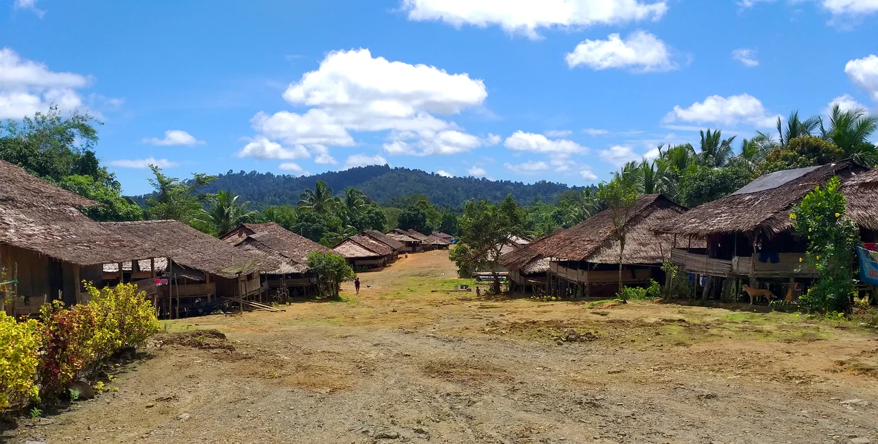
Villages in the Canopy's Shadow
Four villages sit within the park's boundaries: Manusela, Ilena Maraina, Selumena, and Kanike. Their residents belong to ethnic groups who have lived in the forest long before the Indonesian government drew lines on a map in 1997 and called it a national park. The Manusela people, who gave the park its name, are part of the broader Alifuru cultural tradition that sees Seram as sacred ground. But sacredness has not shielded them or the forest from modern pressures. Logging concessions cover 48 percent of Seram's forest, and illegal logging has been documented inside the park itself. The tension between conservation law and economic reality is constant -- the trees that shelter the cockatoos are the same trees that fetch prices at sawmills.
Where the Rivers Begin
The park's boundaries trace a transect from the northern coast to the southern slopes of Binaiya, encompassing swamp forest, lowland rainforest, and montane ecosystems in a single protected area. Melaleuca trees fringe the coastal zones, their papery bark peeling in the salt air. Inland, the canopy thickens into a wall of green where Alstonia scholaris towers above the understory and tropical almonds drop their broad leaves into slow streams. This is the headwater country of Seram, where rainfall collected by the mountains feeds rivers that sustain villages and mangrove estuaries downstream. The park was established to protect this continuity -- the unbroken chain from cloud forest summit to coral reef shore that makes island ecosystems both fragile and whole.
From the Air
Located at 3.05S, 129.43E on Seram island in the Maluku archipelago, eastern Indonesia. The park covers the mountainous interior of the island, with Mount Binaiya (3,027m) visible as the highest point. The island is roughly rectangular and surrounded by the Banda Sea and Seram Sea. Nearest airport is Pattimura Airport (WAPP) on Ambon island to the southwest. Approach from the south for dramatic views of Binaiya's ridgeline against the northern coast.
Nearby Stories
- When the Spice Islands Shook 76 km away
- Misool: Port of Kings 105 km away
- Ambon Island: The Clove That Changed Everything 113 km away
- Where the Spice Routes Converged 119 km away
- Banda Neira: Fortress, Prison, Paradise 136 km away
- The Amazon of the Seas 143 km away
- The Prayer That Became an Island 238 km away
- The Abyss That Isn't a Trench 256 km away