Misool: Port of Kings
The name means harbor. In the Ma'ya language, Misool describes what the first king from Waigeo found when he arrived: a sheltered anchorage, a place to land, a kingdom waiting to be claimed. The island's original inhabitants, the Matbat people, had their own name for it -- Batan Mee -- but the name that stuck belongs to the newcomers, as names often do. Today Misool is one of the four major islands of the Raja Ampat archipelago in Southwest Papua, Indonesia, a 2,034-square-kilometer landmass of rainforest-cloaked limestone rising 561 meters at its highest point, flanked by some of the most biodiverse coral reefs on the planet.
Kingdoms and Sultanates
Islam reached the Raja Ampat Islands in the 15th century through political and economic ties with the Bacan Sultanate, and by the 16th and 17th centuries, the Sultanate of Tidore exerted close influence over Misool. The island was governed by a king in Lilinta, on the southeast coast, descended from Gurabesi of Waigeo -- a figure whose lineage threads through the mythologies of multiple Raja Ampat kingdoms. Tidore appointed a second king in Waigama, on the northwest coast, creating a dual-authority arrangement that reflected the island's geographic split between two coastlines facing different seas. The inhabitants speak Ma'ya, Biga, and Matbat, along with Indonesian and Papuan Malay, a linguistic diversity that mirrors the centuries of trade, migration, and political negotiation that shaped this corner of the Pacific.
Rainforest Menagerie
Misool belongs to the Vogelkop-Aru lowland rain forests ecoregion, the same biological province that encompasses the other Raja Ampat Islands and the Bird's Head Peninsula on mainland New Guinea. The forests here are ancient lowland communities -- alluvial rainforest in the flats, hill rainforest on the slopes -- and they shelter an animal roster that reads like an inventory of Australasian oddities. Common spiny bandicoots rustle through the undergrowth. Spotted cuscuses cling to branches in the canopy. Sugar gliders launch between trees at dusk. Fruit bats of several species crowd the twilight, including the spectacled flying fox with its wingspan of over a meter. And threading through the upper canopy, the lesser bird-of-paradise performs its elaborate courtship display, hanging upside down from a branch with its plumes fanned wide, a spectacle that early European explorers assumed could only exist in paradise itself.
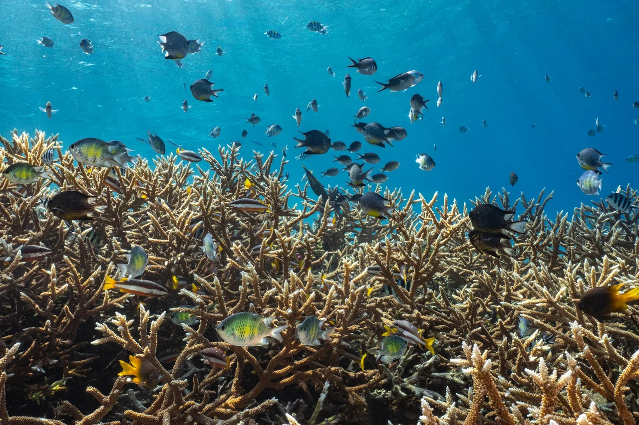
The Crown Jewel's Southern Reach
Misool sits within the Coral Triangle, the roughly triangular zone of tropical seas between the Philippines, Borneo, and New Guinea that contains the highest concentration of marine species anywhere on Earth. The island's reefs are among the most productive in the entire triangle. Two rainbowfish species are endemic to Misool's freshwaters: Melanotaenia misoolensis and Melanotaenia flavipinnis, the yellowfin rainbowfish, small iridescent fish that have evolved in isolation from their mainland relatives. In the coastal waters southeast of the island, the Raja Ampat Marine Recreation Park was designated in 2009, providing formal protection for reef systems that had been sustained for generations by local fishing communities who understood, long before conservation biology existed as a discipline, that you do not destroy what feeds you.
The Nature Reserve
Since 1982, the southern portion of Misool has been designated a nature reserve, covering 840 square kilometers of forest, coastline, and the waters surrounding them. The reserve protects a cross-section of the island's ecosystems, from the limestone ridges where pitcher plants trap insects in their fluid-filled cups to the mangrove fringes where juvenile reef fish shelter before venturing into open water. Misool's relative remoteness -- accessible mainly by boat or small aircraft -- has been its most effective conservation tool. Development pressure remains low compared to more accessible Indonesian islands, and the reefs have largely avoided the blast fishing and cyanide poisoning that have devastated coral systems elsewhere in Southeast Asia. The challenge now is maintaining that protection as dive tourism grows and the outside world discovers what local communities have always known.
Approaching Misool
From the air, Misool reveals itself gradually. The island rises from turquoise shallows as a dark mass of forest, its coastline scalloped with bays and fringed by smaller islets and limestone karst formations that stand in the water like ruined cathedrals. The reef systems are visible as pale halos beneath the surface, their geometry shifting with the angle of the sun. Waigama sits on the northwest coast, Lilinta on the southeast, the two towns that once hosted rival kings now connected by trails through forest that has not fundamentally changed since those kings were appointed. The three other major Raja Ampat islands -- Salawati, Batanta, and Waigeo -- are scattered to the north and northwest, each visible on clear days as dark silhouettes on the horizon. Together they form the Four Kings, an archipelago named for a myth about seven eggs, four kingdoms, and a land where the boundaries between history and story have never been firmly drawn.
From the Air
Located at 1.87S, 130.14E in the Raja Ampat archipelago, Southwest Papua, Indonesia. Misool is the southernmost of the four major Raja Ampat islands, visible as a large forested landmass surrounded by turquoise reef shallows. Recommended viewing altitude: 15,000-25,000 ft to see both the island and surrounding reef patterns. Nearest major airport: Sorong/Domine Eduard Osok (WASS) approximately 200 km to the north-northwest. Small airstrip access only on the island itself. Expect tropical cloud buildup, especially in the afternoons. The Coral Triangle waters are often a striking turquoise visible from cruise altitude.
Nearby Stories
- The Prayer That Became an Island 56 km away
- The Amazon of the Seas 85 km away
- Seram's Last Wilderness 110 km away
- Three Thousand Feet Short 111 km away
- The Nutmeg Wars of Banda Neira 151 km away
- The Four Kings 153 km away
- The Ocean's Hidden Crossroads 171 km away
- One Stove, Three Stones 192 km away