The Four Kings
A woman finds seven eggs. Three hatch into kings who claim the islands. A fourth hatches and migrates to Seram. A fifth becomes a woman who washes away to Biak. A sixth produces a spirit. The seventh never hatches at all -- it turns to stone and is worshipped as a king on Waigeo. This is the origin story of Raja Ampat, the Four Kings, an archipelago of more than 1,500 islands, cays, and shoals scattered off the northwest tip of New Guinea's Bird's Head Peninsula. The myth accounts for four kingdoms but names five -- Waigeo, Salawati, Sailolof, Misool, and Waigama -- and which four are the true Raja Ampat depends on whether you ask the locals or the Sultanate of Tidore. It is the kind of place where even the founding story cannot quite contain itself.
Fifty Thousand Years of Footprints
Archaeological evidence from the Mololo Cave site indicates humans first reached these islands more than 50,000 years ago, when lower sea levels connected Misool and Salawati to the New Guinea mainland, and Waigeo and Batanta formed a single island called Waitanta. Those early arrivals processed tree resins and hunted native animals. Roughly 3,500 years ago, pottery-making communities arrived and likely brought Austronesian languages with them. The Portuguese navigator Jorge de Menezes became the first recorded European to sight and land on the islands in 1526, en route from Biak to Halmahera. Islam had already arrived a century earlier through ties with the Bacan Sultanate, and by the 16th and 17th centuries, the Sultanate of Tidore claimed close economic and political influence over the archipelago. The English explorer William Dampier later gave his name to the strait separating Batanta from Waigeo. In 1759, Captain William Wilson, sailing the East Indiaman Pitt, named another passage between Batanta and Salawati. The islands collected names the way reefs collect coral -- layer upon layer, each generation adding its own.
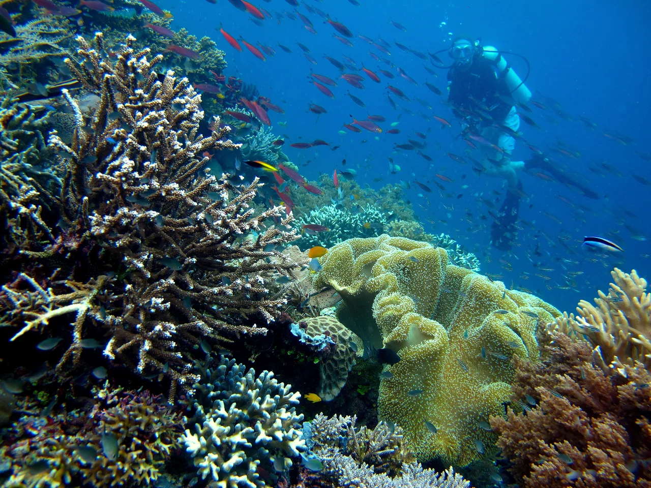
The Epicenter
Marine biologists do not use the word lightly: Raja Ampat is the global epicenter of tropical marine biodiversity. The archipelago sits within the Coral Triangle, the zone of Southeast Asian seas bounded roughly by the Philippines, Borneo, and New Guinea. Within this triangle, Raja Ampat's reefs hold more than 600 species of hard coral -- approximately 75 percent of all known species worldwide -- and more than 1,700 species of reef fish on both shallow and deep mesophotic reefs. The waters harbor dugongs, blue whales, pygmy blue whales, Bryde's whales, Omura's whales, sperm whales, dolphins, orcas, and endangered whale sharks. Over 100 species of reef fish are found here and nowhere else. In 2025, UNESCO designated the islands a biosphere reserve, formal recognition of what surveys had been confirming for decades: no comparably sized marine ecosystem on Earth matches Raja Ampat's concentration of life.
Reef, Ruin, and Recovery
Conservation here is neither simple nor settled. In March 2017, the 90-meter British cruise ship Caledonian Sky ran aground on a reef at low tide, destroying an estimated 18,882 square meters of coral in a joint government-insurance survey. Environmental assessments placed the potential loss to Indonesia at $18.6 million, with a recovery timeline spanning decades. The incident exposed the tension between tourism revenue and reef preservation -- a tension the islands had managed to defer but never resolve. A more hopeful story involves zebra sharks. Overfishing that accelerated in the 1990s reduced the local population to perhaps 20 individuals. In 2022, a breeding and release initiative launched with the goal of returning 500 sharks to Raja Ampat's waters by 2032. Local villagers on northeast Waigeo have also taken up turtle conservation, protecting nests and relocating eggs of leatherback, olive ridley, and hawksbill turtles, supported by government and NGOs. In 2019, local divers began controlling crown-of-thorns starfish by injecting them with a vinegar solution -- a grassroots intervention that keeps the reef's predator-prey balance from tipping.
The People Between Two Worlds
Roughly 70,000 people live across the archipelago, spread in small communities whose primary occupation is fishing. Raja Ampat's population reflects its layered history: the people share cultural ties with both Moluccan and Papuan communities, speaking a mix of Papuan and Austronesian languages. The Muslim proportion is higher than in most other Papuan areas, a legacy of centuries under Tidore's sphere of influence. Traditional culture remains strong, coexisting with the Indonesian administrative structure that carved the Raja Ampat Regency out of Sorong Regency in 2004. The regency encompasses roughly 70,000 square kilometers of land and sea, though only about 8,000 square kilometers of that is dry ground. The rest is water -- and the water, here, is the point. These communities have oriented their lives around the sea for millennia. The reefs are not an attraction to be marketed. They are the foundation on which everything else is built.
The Archipelago from Above
From cruising altitude, Raja Ampat resolves into a scatter of dark green islands set in water that shifts from deep indigo to pale aquamarine where the reefs rise close to the surface. The four main islands -- Misool to the south, Salawati and Batanta in the middle, Waigeo to the north -- are substantial landmasses covered in rainforest, home to red birds-of-paradise and Wilson's bird-of-paradise found nowhere else on the planet. The endemic palm Wallaceodoxa raja-ampat, only recently discovered, adds to a terrestrial biodiversity that the marine fame tends to overshadow. Between the major islands, Dampier Strait and the other passages funnel currents that bring nutrients and plankton to the reefs, sustaining the food web that makes this corner of the Coral Triangle so extraordinarily productive. The smaller islands number in the hundreds, many uninhabited, their limestone karst cliffs dropping vertically into the sea. From above, the whole system looks improbable -- too much life concentrated in too small a space, as if evolution decided to run every experiment at once and keep all the results.
From the Air
Located at 0.23S, 130.52E off the northwest tip of New Guinea's Bird's Head Peninsula, Southwest Papua, Indonesia. The archipelago is spread across a wide area just south of the equator. The four main islands (Waigeo, Batanta, Salawati, Misool) are visible as large forested landmasses; the 1,500+ smaller islands appear as scattered green dots in turquoise water. Recommended viewing altitude: 25,000-35,000 ft to see the full archipelago spread. Nearest major airport: Sorong/Domine Eduard Osok (WASS). Dampier Strait between Batanta and Waigeo is a prominent visual landmark. Expect tropical convective cloud, especially afternoon buildup. Reef systems visible as pale turquoise halos around islands in clear conditions.
Nearby Stories
- The Prayer That Became an Island 71 km away
- Sausapor: Where Turtles Nest and Empires Landed 109 km away
- The Ocean's Hidden Crossroads 139 km away
- The Lake People's Living Palette 144 km away
- The Amazon of the Seas 176 km away
- Aketajawe-Lolobata National Park 239 km away
- Halmahera Rain Forests 311 km away
- Mapia Atoll 367 km away