Mapia Atoll
By the year 2000, only one person on Earth could still speak the Mapia language. The elderly resident of this five-island atoll in Indonesia's Papua province carried the last living trace of a tongue that had been spoken here for centuries -- a language with no written grammar, no dictionary, no recording project to preserve it. When that speaker died, Mapia joined the long list of languages swallowed by time. The atoll itself, barely 199 people strong as of the 2020 census, keeps accumulating identities even as it loses them: Mapia, Freewill Islands, San David, Guedes -- each name a sediment layer left by the empires that passed through.
Spain's Forgotten Claim
In 1948, a Spanish researcher named Emilio Pastor submitted a paper to his government arguing something remarkable: that Mapia Atoll, along with a handful of other Micronesian islands, still legally belonged to Spain. His reasoning was straightforward. The German-Spanish Treaty of 1899, which transferred the Northern Mariana Islands and the Caroline Islands to Germany, had failed to mention these smaller islands by name. The Spanish government studied the case in 1949 and accepted Pastor's interpretation. Then it did nothing. Spain has never formally reclaimed the islands, and Indonesia administers the atoll as part of West Supiori District within Supiori Regency. The legal ghost of Spanish sovereignty persists as a curiosity -- a bureaucratic oversight frozen in amber for more than a century.
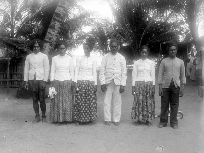
Sailors, Sultans, and Seagull Tattoos
Long before European treaty-makers drew their lines, Mapia Atoll was part of the Tidore Sultanate's domain, counted among the Papoua Gam Sio -- "The Nine Negeri of Papua." The local chieftain held the title Sangaji Meraudi, a position documented when Arthur Wichmann photographed the Sangaji and his family during an expedition to New Guinea in 1903. The atoll's ties to the wider Papuan world ran through the Biak sailors of Supiori, who had been making the ocean crossing to Mapia for centuries. The journey was significant enough to warrant a ritual: upon returning home, the sailors would tattoo themselves in the shape of a seagull, called Manmarmar. These tattoos were markers of distance covered and waters mastered, proof that a man had sailed beyond the horizon and come back.
Five Islands at the Edge of the World
Mapia Atoll sits 190 kilometers north of Manokwari and 630 kilometers from Palau, a scattering of land in the open Pacific. Its two main islands, Bras (also called Berasi) and Pegun (also called Mapia), are joined by the smaller Fanildo and two minor islets -- Bras Kecil and Fanildo Kecil. Together they constitute a fragment of Indonesia's easternmost province, a place where the archipelago dissolves into the vastness of the Pacific Ocean. The population has hovered under 200 for decades, a community sustained by the reef and the sea, living on land that barely rises above the waterline. Whatever commerce or governance connects Mapia to the Indonesian mainland arrives slowly, across hundreds of kilometers of open water.
From the Air
Located at 0.88N, 134.31E in the Pacific Ocean, approximately 190 kilometers north of Manokwari, Papua. The atoll consists of five small islands -- Bras, Pegun, Fanildo, and two minor islets -- forming a low-lying ring visible as pale sand against deep blue water. Nearest significant airport is Rendani Airport (ICAO: WASR) in Manokwari. The atoll has no airstrip; approach by sea only. Best spotted from altitude in clear conditions as a thin reef formation.
Nearby Stories
- Spring Rain on Dark Water 159 km away
- Manokwari: Where Empires Came and Went 180 km away
- Biak Archipelago 207 km away
- Where the Ancestors Still Watch 224 km away
- Biak 237 km away
- Hatohobei 371 km away
- Sonsorol 520 km away
- Yoshino-Kumano National Park: Cherry Blossoms, Sacred Water, and Ancient Stone 3623 km away