Hatohobei
Twenty-five people elect a governor. They also elect a legislature, maintain a state constitution adopted in 1983, and send a representative to Palau's House of Delegates. Hatohobei, the southernmost of Palau's sixteen states, holds the distinction of being the least populous first-level administrative subdivision in the world. Its total land area -- Tobi Island and Helen Reef combined -- amounts to 0.88 square kilometers. What it lacks in size and population, it compensates for with a sovereignty apparatus that would suit a territory a thousand times its scale.
Tobi: A Capital in Coconut Palms
Tobi Island, also called Hatohobei or Kodgubi in the local Tobian language, covers just 0.85 square kilometers. Its highest point reaches six meters; most of the island sits less than three meters above the sea. The southwestern shore holds the abandoned village of Tobi, which serves as the state capital despite its emptied houses. Coconut palms cover the island almost entirely, with a cultivated area near the center that once sustained a larger population. In 1962, eighty people lived here. By 1972, the number had dropped to 79. The 2015 census counted 25, with a median age of 21.5 years. Three official languages -- Tobian, English, and Sonsorolese -- serve this shrinking community, a linguistic richness that outpaces many places ten thousand times its size.
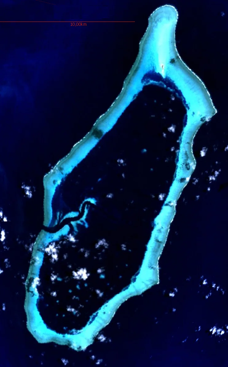
Helen Reef: A Lagoon Larger Than the State
Seventy kilometers east of Tobi lies Helen Reef, known locally as Hotsarihie. The reef is enormous relative to the state it belongs to: 25 kilometers long, nearly 10 kilometers wide, with a lagoon spanning 103 square kilometers. Its single island -- Helen Island -- is a sliver of densely wooded sand dune, roughly 400 meters long and 20 to 40 meters wide. The dune is migrating southeast at a rate of three to four meters per year, slowly falling into the lagoon. A marine ranger station, established in the early 1990s and staffed by three people, guards the reef against foreign poachers. Spanish naval officer Felipe Tompson first charted the reef in 1773, naming it San Felix shoal. BirdLife International has designated Helen Island an Important Bird Area: some 25,000 black noddies nest here, along with populations of sooty and greater crested terns.
Kite Fishing and the Old Ways
The surrounding ocean provided the primary source of protein for Hatohobei's inhabitants, and given the tiny amount of available land, virtually every square meter was once exploited for settlement or subsistence. Traditional fishing practices on Tobi included kite fishing -- a technique documented in a 1977 issue of KiteLines magazine, where fishermen used kites to carry lines and lures far from shore, reaching fish that no casting arm could manage. The practice connected Hatohobei to a broader Oceanian tradition of using wind and ingenuity to extend the reach of island communities into the open sea. Archaeological surveys have found platforms and pathways from traditional villages, along with individual old dwelling places scattered across the island.
The Ghost Reef at the Border
Fifty kilometers east of Helen Reef, maps and Hatohobei's own state constitution reference Transit Reef -- Pieraurou in Tobian, meaning "Sandy Navigation Point." It would constitute Palau's southernmost feature if it existed as an island. But current Sailing Directions do not list it, and its Tobian name describes a submerged sandbar rather than a reef or island. Transit Reef may be a phantom island, a geographic feature that appeared on charts and in legal documents but cannot be found above the waterline. Its constitutional status makes it one of the more unusual examples of a jurisdiction claiming territory that may not exist in any meaningful physical sense -- a sovereignty question that, on an atoll where 25 people maintain a full state government, feels somehow fitting.
From the Air
Located at 3.01N, 131.12E in the western Pacific, far south of Palau's main island group. Tobi Island is extremely low and small -- 0.85 square kilometers with a maximum elevation of 6 meters. Helen Reef lies 70 kilometers to the east and is largely submerged, with a single tiny islet. No airstrip exists; access is by sea only. The nearest airport is Roman Tmetuchl International Airport (ICAO: PTRO) in Koror, approximately 600 kilometers to the northeast. The reef formations may be visible from altitude as turquoise rings against deep ocean blue.
Nearby Stories
- USS Shelton (DE-407) 129 km away
- Japanese Submarine Ro-41 148 km away
- Sonsorol 236 km away
- Morotai Island 290 km away
- Spring Rain on Dark Water 351 km away
- The Island That Reached the Philippines 391 km away
- Miangas 492 km away
- Island of Palmas Case 545 km away