Biak Archipelago
A storm in 1526 blew the Portuguese navigator Jorge de Menezes off his course from Malacca toward the Spice Islands and dumped him, finally, on an island he had no name for. He spent the season there waiting out the weather. The Portuguese chartmakers who came after him would call the place Ilha de Dom Jorge - Jorge's Island - and eventually just Ilha de S. Jorge. More importantly, Menezes gave the archipelago itself a name drawn from local Malay and Papuan usage: Ilhas dos Papuas, the Islands of the Papuans. The name stuck to half of New Guinea, to a province of modern Indonesia, and to the people who had lived on these islands for thousands of years before any Portuguese ship arrived.
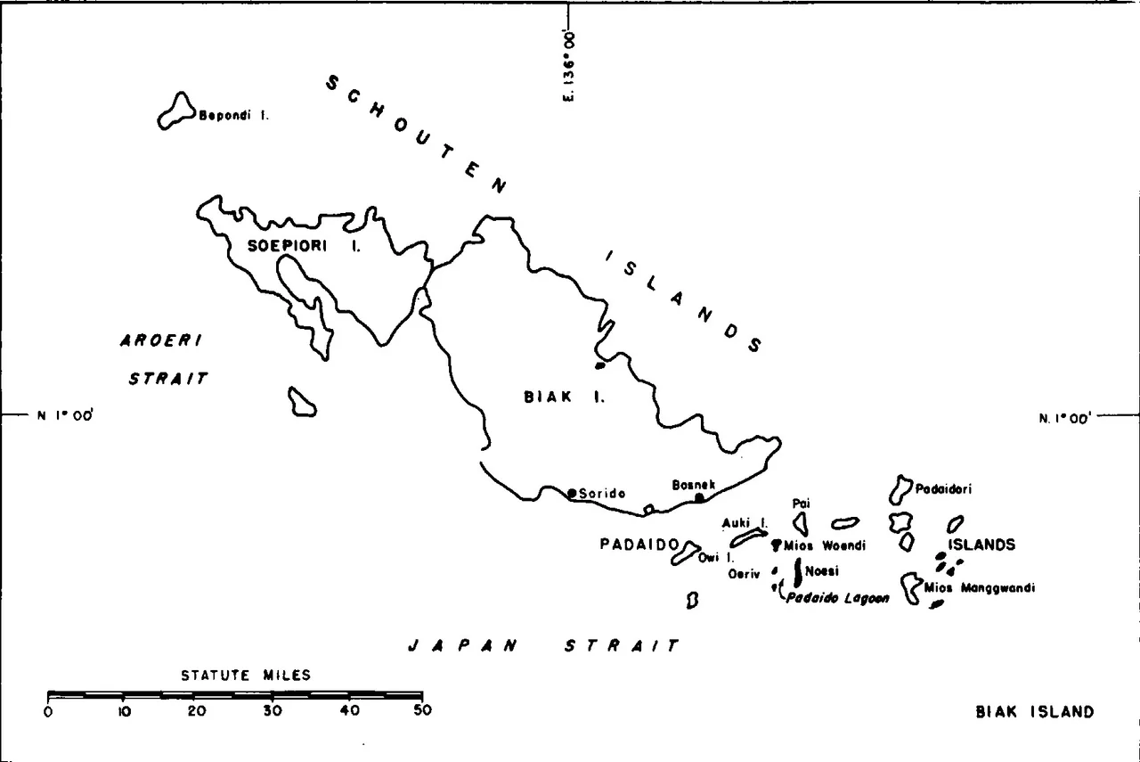
Three Islands in a Bay
The Biak Archipelago - also called the Schouten Islands, after the Dutch explorer Willem Schouten who charted them in 1615, or the Geelvink Islands in older Dutch usage - sits 50 kilometers off the northwestern coast of New Guinea, inside the wide curve of Cenderawasih Bay. Three main islands do the work: Biak, the largest and most populated; Supiori, separated from Biak by a narrow shallow channel; and Numfor to the southwest. Around them scatter the smaller Padaido islands to the south and southeast, a reef-fringed archipelago within an archipelago. About 130,000 people live in the group. The bulk of them are on Biak, clustered around the south coast; the interior and outer islands remain thinly settled, draped in rainforest.
Spanish, Portuguese, Dutch
Menezes was not the only European trying to find his way home through these waters. The Spanish navigator Alvaro de Saavedra landed on Yapen, just south of Biak, on 24 June 1528 while attempting the impossible return from Tidore to New Spain. He called the group Islas de Oro - the Golden Islands - though it is unclear why. In 1545, Inigo Ortiz de Retes visited aboard the galleon San Juan. Portuguese charts of Gaspar Viegas from about 1537, and the maps of Joao de Lisboa and Bartolomeu Velho a generation later, sketched the islands into European geography. The Tidore Sultanate, centered in the Maluku Islands to the west, already knew these islands well. Biak's seafarers had been paying tribute to the sultan for generations, and the influence runs deep in local names - clan names like Rumbiak and Rumbewas carry the Tidore word rum, meaning house.
Birds That Live Nowhere Else
Biologists call this ecoregion the Biak-Numfoor rain forests, and the phrase carries weight. These small islands have the most highly endemic avifauna of any single area in the New Guinea region - over a hundred bird species, of which eleven to sixteen exist nowhere else on Earth. Black-winged lories with scarlet heads. The Biak scrubfowl that buries its eggs in warm volcanic soil. Two species of paradise kingfisher, the Biak and the Numfor, each confined to a single island. The long-tailed starling, the Biak white-eye, the Biak monarch. Add a flock of endemic mammals, including the marsupial Biak glider, the Japen rat, and two species of giant naked-tailed rat, and you have an evolutionary laboratory the size of a small county - every population isolated long enough to drift its own way, short enough to remain vulnerable.
The Coral Triangle's Corner
The water around the archipelago is as rich as the land is specialized. These seas fall within the Coral Triangle, the marine region stretching from Indonesia to the Solomon Islands that contains more coral reef species than anywhere else on Earth. Divers come for the walls, the wrecks, and the sheer number of fish. Two marine protected areas watch over the most vulnerable zones: the Biak Numfor Locally Managed Marine Area, established in 2015, covers the southern coast of Biak and Numfor's eastern shore; and Padaido Marine Recreation Park, established in 2009, protects the small-island scatter south of Biak. The forest on land has been thinned by logging, and the pressure has not ended. Two terrestrial reserves - Pulau Supiori Nature Reserve, covering most of Supiori, and the Biak Utara Nature Reserve across the channel - hold the remaining old growth. For an island group that compressed so much diversity into such a small space, the margins are thin.
Living on Crowded Ground
The Biak Islands are among the most densely populated parts of Papua province - an unusual distinction for a corner of Indonesia often imagined as empty. The population density reflects deep history: good soils, reliable fishing, sheltered harbors, and the archipelago's long role as a trading crossroads between New Guinea, the Malukus, and the wider archipelago. The islands enclose the north side of Cenderawasih Bay; Yapen Island lies across a broad channel to the south; Numfor faces west toward the open Pacific. From altitude, the whole group reads as a clean geometric puzzle - three green crescents in a deep blue bay, with the vast dark mass of mainland New Guinea rising beyond them.
From the Air
The Biak Archipelago is centered around 0.9 degrees south, 135.9 degrees east, inside the wide mouth of Cenderawasih Bay off northwestern New Guinea. From cruising altitude the group reads as three main islands - Biak, Supiori, and Numfor - with Biak's distinctive elongated shape running roughly northwest-southeast. The islands are visible landmarks for any north-coast Papua navigation. The main airport is Frans Kaisiepo (ICAO WABB) on Biak's south coast. The surrounding waters are part of the Coral Triangle; reef structures are visible from low altitude in clear conditions. Equatorial weather brings frequent afternoon convective buildup.
Nearby Stories
- Owi Airfield 37 km away
- The Battle of Noemfoor: Three Airfields and a Forgotten Cost 51 km away
- 1996 Biak Earthquake 59 km away
- Cenderawasih Bay 141 km away
- Mamberamo River 168 km away
- Mapia Atoll 211 km away
- Spring Rain on Dark Water 355 km away
- Mikura-jima 3859 km away