Mamberamo River
On 20 June 1545, the Spanish navigator Inigo Ortiz de Retes stood at the mouth of a river he called San Agustin and claimed the entire coastline for the Spanish Crown. He had sailed along the north coast of a huge island trying to find a way home to New Spain, and it was here, at this river mouth, that he decided to give the place a name that would stick: Nueva Guinea - New Guinea - because the people he met on shore reminded him of the Guineans he had seen on the African coast. The name is awkward and imposed, but it survived. The river did not keep its Spanish baptism. It is now known as the Mamberamo, the second-longest river on the island of New Guinea and the second-largest in all of Oceania by discharge. Its valley is still home to uncontacted peoples, and most of its catchment remains, five centuries after that moment on the beach, unmapped on foot.
Two Rivers Make One
The Mamberamo forms at the confluence of two large upstream tributaries - the Tariku and the Taritatu Rivers - in an interior basin called the Lakes Plains. This basin is flat and wet, covered in freshwater swamp forest and grassland stretching for thousands of square kilometers. Once formed, the Mamberamo flows north through a tightening gap between the Van Rees Range and the Foja Mountains, cutting a series of rapids and gorges through young mountains that are still tectonically rising. The last 160 kilometers of the river are navigable. The river widens and slows in the coastal lowlands, fringing itself with marshes and mangroves, and finally delivers its load into the Pacific Ocean at Cape Narwaku (also called Point D'Urville). Average monthly discharge at the delta over the decade 2003-2012 was 5,014 cubic meters per second - about 158 cubic kilometers of water per year.
The Dam That Never Was
In the 1990s, the Indonesian government developed plans to construct a large hydroelectric dam somewhere on the Mamberamo. The scheme would have submerged a significant part of the Lakes Plains basin. The Asian financial crisis of 1998-1999 shelved the proposal. The project has not formally died, and environmental groups continue to watch for its revival; feasibility studies kept appearing as recently as 2023. For now, the Mamberamo remains the second-largest river in the world to be completely unfragmented by dams in its entire catchment, behind only the Fly River on the New Guinea-Papua New Guinea side of the island. What happens to these two river systems will determine what large undammed tropical rivers look like for future generations.
A Basin of New Species
The Mamberamo basin is one of the most important biodiversity hotspots in New Guinea, and the numbers back it up. One botanical survey in the Foja Mountains foothills identified 487 plant species; 156 of those could not be assigned to any known taxon. The basin holds swamp forests, seasonally flooded lakeside forests, and sago forests dominated by the sago palm - a tree that provides the basin's traditional staple food. Crocodiles patrol the river, in both varieties: the New Guinea freshwater crocodile and the saltwater crocodile, which wanders freely into estuaries. The northern cassowary, the Victoria crowned pigeon, and the black-spotted cuscus maintain significant populations here. The rediscovery of Berlepsch's bird of paradise - long known only from trade skins - happened in this basin. So did the descriptions of the wattled smoky honeyeater, the giant rat Mallomys, the pygmy possum Cercartetus, and more than seventy other new species reported since the early 2000s.
Geologically Young, Still Moving
The Mamberamo basin is geologically a baby - middle to late Miocene, less than 15 million years old - and remains tectonically active. Earthquakes and landslides regularly reshape the steeper terrain. The sediment-rich rivers belong to what geologists call white-water systems, analogous to Amazon tributaries, and the soil orders - inceptisols predominantly, with ultisols and entisols mixed in - are all fine-textured and poorly drained. The river is famously meandering; banks erode on one side while new sediment builds up on the other, and the channel wanders year by year. For a river system this large, staying undammed means staying dynamic. Some floodplain forests survive precisely because nobody can build a permanent road across a river that moves when it rains.
Three Hundred Years of Exploration
After Ortiz de Retes named the island, the Mamberamo waited three centuries for another European to enter its mouth. The first to do so was a Dutchman named D. F. van Braam Morris in 1883. Residents from the northern Moluccas - the term meant local administrators under the Dutch colonial system - rowed up the river from Ternate to confirm that it was navigable by steamer. Van Braam Morris returned the following year aboard the steamship Havik and traveled about 60 miles upstream. The Mamberamo-Foja Wildlife Reserve, 16,610 square kilometers, now covers much of the river's middle and lower course. Most residents in the basin practice subsistence hunting, fishing, and small-scale agriculture; they trade crocodile skins, dried fish, and gaharu (agarwood resin). A handful of groups remain entirely uncontacted. In a river valley that spans the full width of Indonesian Papua's interior, the Mamberamo is still mostly itself.
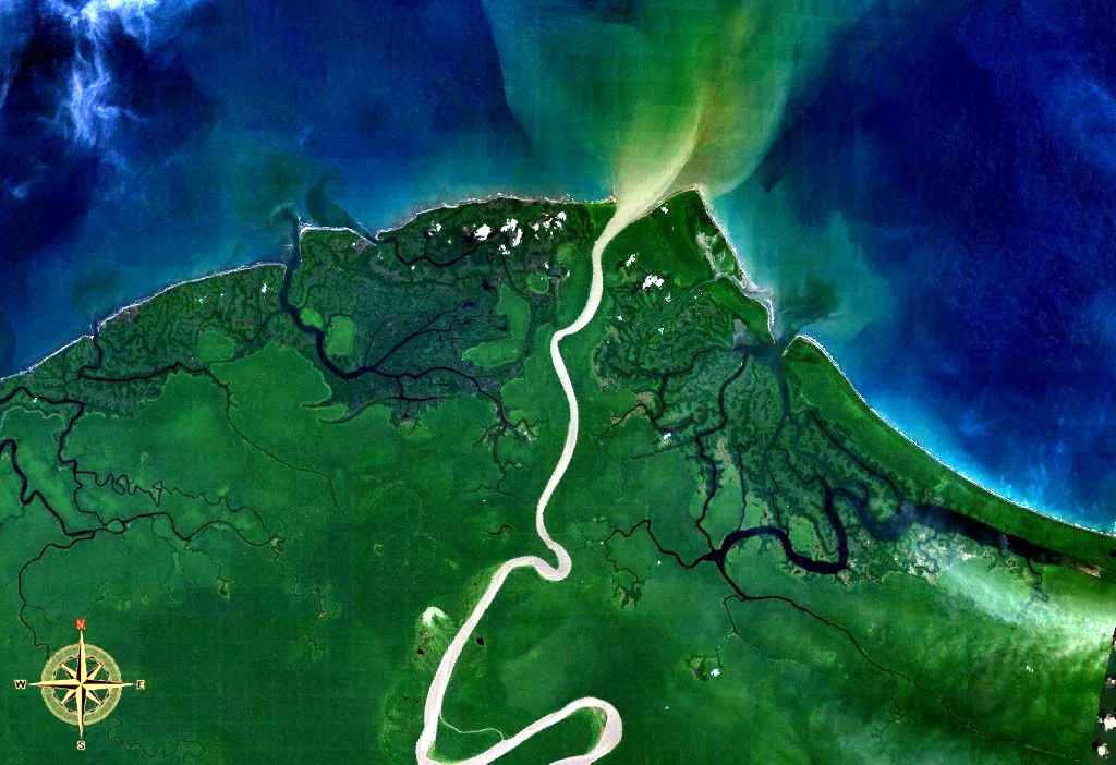
From the Air
The Mamberamo River flows northward through Indonesian Papua, with its delta reaching the Pacific at Cape Narwaku around 1.47 degrees south, 137.9 degrees east. From cruising altitude, the river system is unmistakable - a wide, meandering dark-blue line cutting through unbroken green between the Van Rees Range to the west and the Foja Mountains to the east. The Lakes Plains basin upstream shows as an unusual lighter-toned expanse of swamp and grassland visible in clear conditions. The nearest significant airport is Jayapura's Sentani Airport (ICAO WAJJ) to the east, though the basin is served mainly by missionary and charter aircraft to small airstrips at villages like Dabra. Expect cloud buildup over the ranges and humid visibility over the lowlands.
Nearby Stories
- Battle of Lone Tree Hill 36 km away
- Battle of Wakde 59 km away
- 1996 Biak Earthquake 66 km away
- Ambai Archipelago 126 km away
- Foja Mountains 138 km away
- Owi Airfield 142 km away
- Frans Kaisiepo Airport 209 km away
- 2016 Alfa Indonesia DHC-4 Crash 267 km away