Sausapor: Where Turtles Nest and Empires Landed
The landing strip near Mar is still visible. More than eighty years after American engineers carved it from the coastal scrub of northwestern New Guinea, the scar persists in the landscape, a fading signature of Operation Typhoon. But Sausapor was never really about the war. Long before the 6th Infantry Division waded ashore on June 30, 1944, and long after the last radar station went silent, this stretch of coastline on the Bird's Head Peninsula belonged to the sea turtles. They crawl up the same beaches where soldiers once dug foxholes, laying their eggs in sand that has absorbed both shell casings and centuries of tidal rhythm. Sausapor is a town of about a thousand people on the northern coast of the Vogelkop, fifteen miles west of Tanjung Yamursba, the northernmost point of New Guinea. It is remote by almost any standard. And yet history has found it repeatedly.
Choosing Your Own Colonizer
When the Dutch claimed this part of New Guinea, they brought Protestant governance. The villagers of Sausapor had other ideas. Roman Catholicism spread through the town during the colonial period, not because the Dutch imposed it, but because the residents preferred a Catholic mission running their affairs to a formal Dutch Protestant administration. It was a quiet act of defiance dressed as devotion, a community selecting its own form of external authority rather than accepting the one assigned to them. The region had its own economic identity as well. Sausapor was noted as a cloth-producing center, a detail that hints at trade networks reaching far beyond the immediate coastline. Today the district contains ten villages, from Bondek to Uigwem, and the main ethnic groups are the Karon and Yeden, with sub-groups including the Karon Pantai, Karondori, Marei, Madik, Meyah, Haram, and Arfak. At least 400 people in the town speak the Je dialect of the Abun language, one thread in the extraordinary linguistic tapestry of western New Guinea.
Operation Typhoon
On June 17, 1944, the submarine S-47 slipped out of the Admiralty Islands carrying Alamo Scouts, intelligence agents, and hydrographic surveyors. Their mission: reconnoiter the coastline near Sausapor for an amphibious landing on the Vogelkop Peninsula. Lieutenant Lloyd V. Young commanded the boat. The reconnaissance party went ashore near Sausapor-Mar on June 23 and spent a week mapping the terrain. What they found redirected the entire operation fifty-five miles northeast of Sorong. Two weeks later, on June 30, Operation Typhoon hit the beaches. Major General Franklin C. Sibert's Typhoon Task Force, built around the 6th Infantry Division, landed at Sansapar, Mar, and the offshore islands of Middelburg and Amsterdam. Every landing was unopposed. The Japanese 35th Division did not reach the area until August 16, nearly seven weeks later. By the end of August, the Typhoon Task Force had suffered 14 killed and 35 wounded, while Japanese losses were estimated at 385 killed and 215 captured. A fighter runway went up on Middelburg Island. A bomber strip was built near Mar. Sausapor itself became an air warning radar station, its strategic value lying not in what it contained but in what it protected.
The Birds of Sausapor
In 1939, the Academy of Natural Sciences of Philadelphia published an inventory of bird species collected or sighted near Sausapor. The list runs to dozens of species and reads like a roll call of Papuan avian diversity: the grey-headed goshawk at sea level, ospreys, Pesquet's parrot in flocks of five or six, paradise kingfishers with tails longer than their bodies, and the Magnificent riflebird performing its arc-wing courtship display. A pigeon-sized, light blue bird is known to inhabitants as the bocrocu. The names in the scientific record belong to another era's taxonomy, but the birds themselves remain. Sausapor sits at the intersection of habitats that make this part of New Guinea so biologically rich. Coastal mangroves give way to lowland rainforest, which climbs toward the interior mountains of the Bird's Head. Each zone hosts its own community of species. The local tradition of the alin or sera dance, in which participants form a circle, suggests a people who have long observed the natural rhythms around them and woven those observations into culture.
The Turtles' Claim
Before the Dutch, before the Americans, before the Catholic missions and the cloth trade, the sea turtles were already here. Sausapor's coastline is a major breeding ground, and the significance of this nesting habitat has driven conservation efforts for decades. A Sausapor Strict Nature Reserve protecting turtle nesting grounds appears in records as early as 1989, and proposals have been advanced to combine it with the Wewe-Koor and Jamursba-Medi reserves to protect eighty-five kilometers of coastline. The leatherback sea turtle, the largest living reptile, is among the species that use these beaches. Fifty families were once proposed for relocation away from the nesting areas, a measure that speaks to the tension between human settlement and wildlife survival that plays out along remote coastlines worldwide. In Sausapor, that tension is especially acute. The town's population is small, its footprint modest, but the turtles require undisturbed sand in which to lay their eggs and the dark, quiet beaches that allow hatchlings to find the sea by starlight rather than streetlight.
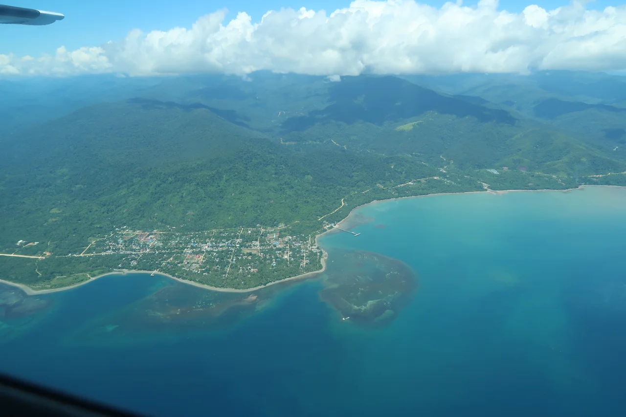
From the Air
Sausapor sits at approximately 0.50S, 132.08E on the northern coast of the Bird's Head (Vogelkop) Peninsula in Southwest Papua, Indonesia. The town is located 15 miles west of Tanjung Yamursba, the northernmost point of New Guinea. Middelburg and Amsterdam Islands are visible 13 miles to the northeast, near Mar. The old WWII landing strip near Mar remains faintly visible from altitude. The nearest significant airport is Domine Eduard Osok Airport (WASS) at Sorong, roughly 100 km to the southwest. Fly at 2,000-4,000 feet for views of the coastline and offshore islands. Watch for tropical convective weather, common in the afternoon.
Nearby Stories
- Spring Rain on Dark Water 26 km away
- Three Thousand Feet Short 46 km away
- Where the Ancestors Still Watch 55 km away
- Waigeo: The Island That Nearly Split in Two 59 km away
- The Lake People's Living Palette 66 km away
- The Prayer That Became an Island 98 km away
- The Architect Bird and the Peninsula It Named 124 km away
- Mapia Atoll 282 km away