The Architect Bird and the Peninsula It Named
Deep in the montane rain forest of the Arfak Mountains, a plain olive-brown bird spends weeks building a structure that would shame most human architects. The Vogelkop bowerbird constructs a domed hut of woven sticks -- five feet high, six feet across -- then decorates the entrance with sorted piles of objects: blue beetle shells in one heap, red berries in another, orange flowers in a third. He rearranges them daily, discarding wilted specimens, auditioning new finds. Females tour multiple bowers before choosing a mate, and their standards are exacting. This bird, endemic to the peninsula, gave the region its European name: Vogelkop, Dutch for "bird's head." The shape of the coastline merely confirmed what the forest already knew.
Where Two Mountain Ranges Guard a Valley
The Bird's Head Peninsula extends roughly 200 by 300 kilometers from the northwestern corner of New Guinea, bounded by Cenderawasih Bay to the east, Bintuni Bay to the south, and the Dampier Strait to the west. Two mountain ranges define its interior. The Arfak Mountains rise to 2,955 meters at Mount Arfak, the peninsula's highest point, located 21 miles southwest of the coastal town of Manokwari. To the north, the Tamrau Mountains reach 2,501 meters at Bon Irau. Between them lies the Kebar Valley, a broad basin that separates the two ranges like a geological breath. Both ranges are built from a jumble of sandstone, limestone, and volcanic rock -- evidence of the tectonic collisions that assembled New Guinea from island-arc fragments over millions of years.
Three Forests in One
The peninsula spans three distinct ecoregions, stacked by altitude. The lowlands and foothills belong to the Vogelkop-Aru lowland rain forests, dense tropical jungle that grades into coastal mangroves along the southern and western shores. Above 1,000 meters, the Vogelkop montane rain forests take over -- more than 22,000 square kilometers of cloud-wrapped canopy where mosses coat every branch and tree ferns grow to the height of houses. Over half of these montane forests fall within protected areas. The biodiversity is staggering even by New Guinean standards: more than 300 bird species have been recorded on the peninsula, at least 20 of which are found nowhere else. The grey-banded munia inhabits a tiny range in the lowlands. The king bird-of-paradise, with its crimson plumage and spiraling tail wires, flashes through the understory. And the Vogelkop bowerbird builds its architectural marvels only here, in the mountains that carry its name.
Twenty-Six Thousand Years of Footprints
Archaeological evidence places human settlement on the Bird's Head at least 26,000 years into the past, making these communities among the oldest continuous inhabitants of the New Guinea highlands. The peninsula's linguistic diversity reflects that depth of tenure. Multiple Papuan language families -- South Bird's Head, East Bird's Head, West Bird's Head -- branch into subfamilies and isolates, languages like Abun, Mpur, and Maybrat that share no demonstrable relationship with any other tongue on Earth. Each isolate represents a lineage of human speech that diverged so long ago, or in such isolation, that the connections have been erased by time. Walking from one valley to the next on the Bird's Head can mean crossing a linguistic boundary older than the pyramids.
The Crown Jewel Offshore
Just across the Dampier Strait from the peninsula's northwest tip lies the Raja Ampat archipelago -- more than 1,500 islands, cays, and shoals scattered around the main islands of Misool, Salawati, Batanta, and Waigeo. Raja Ampat sits at the epicenter of the Coral Triangle, the most biodiverse marine region on the planet, and the numbers bear out its reputation: over 600 species of hard coral (roughly 75 percent of all known species) and more than 1,700 species of reef fish have been documented in these waters. The connection between peninsula and archipelago is not merely geographic. Mangrove-fringed estuaries along the Bird's Head coast serve as nursery habitat for reef species that later migrate to Raja Ampat's coral walls. The terrestrial forests filter sediment and regulate freshwater flow into the strait. Protecting the reefs means protecting the peninsula that feeds them.
Pressure at the Edges
The Bird's Head is not immune to the forces reshaping tropical landscapes across Southeast Asia. Road construction fragments forest corridors. Illegal logging targets valuable hardwoods in unprotected lowland areas. Commercial agricultural expansion and ranching push into the coastal plains, converting forest to plantation. The threats are real but not yet catastrophic -- the peninsula's remoteness and rugged terrain have slowed development compared to Sumatra or Kalimantan. For now, the montane forests remain largely intact, the bowerbirds still build, and the language isolates still echo through valleys where no road has reached. How long that holds depends on whether the peninsula's extraordinary biological and cultural wealth is valued before it becomes a memory. The bowerbird, at least, has no doubts about the worth of careful construction. He will spend weeks on a single bower, discard anything that fails to meet his standard, and start again.
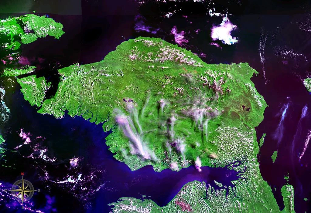
From the Air
Coordinates: 1.53S, 132.75E, the northwestern peninsula of New Guinea island. Visible as a distinct peninsula shape from high altitude, with the Arfak Mountains (2,955m) prominent in the east and Tamrau Mountains (2,501m) to the north. The Kebar Valley is visible between the two ranges. Nearest airports: Rendani Airport in Manokwari (ICAO: WAUU) on the northeast coast, and Babo Airport (ICAO: WASO) to the south on Bintuni Bay. The Raja Ampat archipelago is visible across the Dampier Strait to the west. Approach from the north or west for the best sense of the peninsula's bird-head shape. The dense forest canopy and cloud cover over the mountains are typical features.
Nearby Stories
- Where the Ancestors Still Watch 57 km away
- Where the Mangroves Stand Thirty Meters Tall 67 km away
- Sausapor: Where Turtles Nest and Empires Landed 82 km away
- The People Who Sleep Over Fire 82 km away
- The Gamble Beneath Bintuni Bay 89 km away
- Broken at the River's Edge 113 km away
- Three Thousand Feet Short 134 km away
- Misool: Port of Kings 228 km away