.jpg)
Marine Corps Air Station Cherry Point
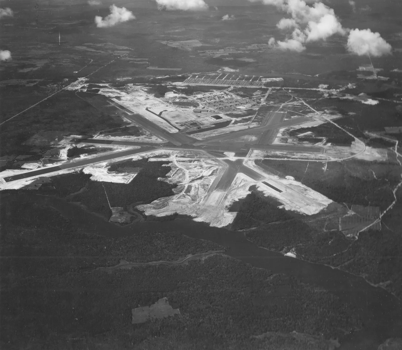
Construction crews broke ground on the eastern North Carolina swamp in November 1941, seventeen days before Japanese planes appeared over Pearl Harbor. By the time the bombs fell on Battleship Row, bulldozers were already draining cypress sloughs along the Neuse River, malaria control crews were dosing the standing water, and 8,000 acres of farms and timberland were being reshaped into what would become the largest Marine Corps air station in the world. The Marines named it Cunningham Field on May 20, 1942, honoring Lieutenant Colonel Alfred A. Cunningham, the Corps' first aviator. The local post office, tucked among the cherry trees that gave the area its name, eventually rebranded the base in its own image.
Born of Swamp and Urgency
Congress authorized the station on July 9, 1941, appropriating $14,990,000 to clear an 8,000-acre tract along Slocum Creek. Clearing began on August 6 with extensive drainage work and malaria control - the coastal lowlands were no place for an airfield without first taming the water. Lieutenant Colonel Thomas J. Cushman supervised construction on behalf of the Marine Corps and went on to become the station's first commanding officer. The mission was straightforward and urgent: train Marines for the Pacific. Squadrons cycled through Cherry Point on their way to Guadalcanal, Tarawa, Iwo Jima. The base also turned outward into the Atlantic itself - in 1943 an Army Air Forces antisubmarine squadron and a Navy squadron each sank a German U-boat just off the North Carolina coast, where Wolfpacks were hunting tankers in sight of the shore.
The Sound of Three Wars
Cherry Point's Korean War contribution was a steady current of trained aviators and air crewmen flowing west to forward units. During Vietnam, three A-6 Intruder squadrons deployed to the Far East from these runways, the slab-sided attack jets streaking out across the rice paddies of Southeast Asia under cover of darkness. Operation Desert Storm in 1991 was a full-tilt deployment - three AV-8B Harrier squadrons, two A-6E Intruder squadrons, a KC-130 Hercules squadron, an EA-6B Prowler squadron, and headquarters detachments from Marine Aircraft Groups 14 and 32 along with the 2nd Marine Aircraft Wing. After September 2001, Cherry Point Marines and Navy Corpsmen flew strike missions over Afghanistan during Operation Enduring Freedom. The runways now stretch across more than 29,000 acres - long enough that NASA designated Cherry Point an alternate emergency landing site for Space Shuttle launches from Cape Canaveral.
The New Generation Arrives
In 2024, VMFA-251 received its first F-35C Lightning II, becoming the first active-duty F-35C squadron based on the East Coast. The fifth-generation fighter, carrier-capable and stealthy, represents the future of Marine fixed-wing aviation. It joins a lineup at Cherry Point that still includes AV-8B Harriers - the British-designed jump jets that have defined the airfield's distinctive sound for four decades - along with VMFA-542's F-35Bs, KC-130J tankers, and VMU-2's RQ-21A Blackjack drones. The base remains headquarters of the 2nd Marine Aircraft Wing, the East Coast aviation muscle of Marine Corps Installations East, with satellite fields at MCALF Bogue for carrier-landing practice, MCOLF Oak Grove for unimproved-surface ops, and MCOLF Atlantic for forward arming and refueling.
Cold War Radar on the Neuse
For six years Cherry Point also pulled Air Force duty. On July 1, 1957, the USAF 614th Airborne Control and Warning Squadron set up shop with AN/FPS-6 and AN/FPS-8 radars mounted on ninety-foot towers, scanning the Atlantic approaches for Soviet bombers. The site became part of the SAGE air-defense network in 1961, feeding contacts to Fort Lee AFS in Virginia where computers and human operators tracked everything in the sky. Hurricane Donna mauled one of the radars in 1960. Budget cuts closed the radar mission on August 1, 1963. The Marines kept one undamaged dish for base air traffic control - a quiet artifact of a different war that never came.
Approach from the Neuse
Cherry Point sits on a peninsula where the Neuse River widens toward Pamlico Sound, the runways oriented to catch the prevailing winds off the Atlantic. From altitude the airfield reads as a great triangle of concrete set in pine forest and tidal marsh, with Slocum Creek curling along its northern edge and the river opening to the southeast. The auxiliary fields scattered across eastern North Carolina mark the wider footprint of Marine aviation in the region. Cherry Branch ferry crosses the Neuse to the north, carrying camp kids and Marines and the occasional sailboat owner from Oriental between the base and the small towns of Pamlico County.
From the Air
Located at 34.9008°N, 76.8808°W along the Neuse River in eastern North Carolina. The base is KNKT (Cunningham Field). Active military airfield - civilian transit prohibited without clearance. New Bern's Coastal Carolina Regional (KEWN) lies about 18 nm northwest and serves as the closest civilian field. Best viewed from 6,000-8,000 feet AGL on transits between New Bern and Beaufort/Morehead City, with the broad mouth of the Neuse and Pamlico Sound to the east. Watch for Harrier and F-35 traffic in the MOAs offshore.
Nearby Stories
- Jones County, North Carolina 13 km away
- Battle of Wyse Fork 19 km away
- Topsail Island 21 km away
- Cape Lookout Coast Guard Station 26 km away
- Portsmouth, North Carolina 28 km away
- Bath, North Carolina 35 km away
- Lake Mattamuskeet 39 km away
- Mercury-Redstone 4 790 km away