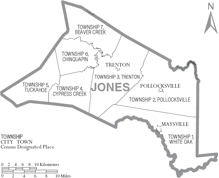

Jones County, North Carolina
Jones County has 9,172 people. Its detention facility has 21 beds, three of them for women, and sits in the basement of the courthouse where the detention staff also double as 911 dispatchers. There is no animal control. The fire departments are entirely volunteer. The whole county runs on one full-time ambulance dispatched out of Trenton, the county seat, with volunteer EMS scattered across the seven townships to back it up. This is what small-county government in eastern North Carolina looks like in the 21st century: lean, improvised, and held together by people who have been holding it together for a long time.
Born of Revolution
Jones County was carved out of Craven County in 1779, in the middle of the Revolutionary War. It was named for Willie Jones, a planter and slaveholder from nearby Halifax who served as president of the North Carolina Committee of Safety during the war. Jones was a passionate Anti-Federalist who opposed the new U.S. Constitution and refused to attend the 1789 Fayetteville Convention that ratified it. Five years after the county's founding, Trenton was named the county seat, a position it still holds. The early economy was the Low Country economy: plantations worked by enslaved African Americans, growing tobacco and cutting timber. The forests of pine and cypress fed naval stores production for nearly two centuries.
Tuscarora and German Palatines
Before the colonial Carolinas reached this far inland, the country was Tuscarora. By the early 1700s German Palatines and Swiss Protestants began arriving via New Bern, the colony Baron de Graffenried founded in 1710. The Tuscarora War followed almost immediately and lasted until 1715, ending with the destruction of Fort Neoheroka and the long migration of most surviving Tuscarora north to join the Iroquois Confederacy as its sixth nation. The forests they had used as hunting ground passed to the newcomers. Place names in Jones County still trail back to those early decades: Pollocksville for Cullen Pollok, Maysville for the May family of nineteenth-century settlers, Trenton named echoing the New Jersey Revolutionary capital.
Croatan and the Great Dover
Most of Jones County is forest and swamp. The Croatan National Forest reaches into the county from Craven, bringing with it Catfish Lake South Wilderness and Pond Pine Wilderness, two pockets of protected longleaf and pond pine where black bears still den. The Great Dover Swamp covers a large area of the county's interior, drained by the Trent River that gives Trenton its name. The Trent eventually joins the Neuse at New Bern and reaches the Atlantic through Pamlico Sound. The county sits eight miles west of the open ocean but has no oceanfront of its own. The waterfront comes from the Trent and the White Oak rivers, and most recreation centers on boating, fishing, and camping. Hunters use the wide expanses of farmland and pine for deer and turkey and the occasional waterfowl set.
Quiet by Choice
The 2020 census found a median age of 48.9 years in Jones County, one of the older medians in the state. Less than 0.1 percent of residents live in urban areas. The economy still leans on tobacco and lumber, with newer hog and chicken operations adding to the mix. The Marine Corps maintains Outlying Field Oak Grove near Pollocksville, a satellite airfield for Cherry Point that is sparsely manned. Otherwise the federal footprint is small. Two highways carry most of the traffic: U.S. 17 north toward New Bern and south toward Jacksonville, U.S. 70 west to Kinston and east to Morehead City. People who live in Jones County tend to like that they live in Jones County. They are not necessarily looking to be discovered.
Flight Context
Jones County stretches across roughly 35.0 degrees north, 77.3 degrees west. View from 3,000 to 5,000 feet AGL to see the Trent River, the Croatan National Forest, and the patchwork of swamp and farmland that defines the county. Nearest airports: Marine Corps Outlying Field Oak Grove (KNJZ) inside the county, Coastal Carolina Regional (KEWN) in New Bern to the northeast, Kinston Regional Jetport (KISO) to the northwest. Watch for restricted airspace tied to Camp Lejeune and Cherry Point operations.
From the Air
Jones County at 35.0 degrees north, 77.3 degrees west. View from 3,000 to 5,000 feet AGL. Airports: KNJZ (Oak Grove), KEWN (New Bern), KISO (Kinston). Watch for Camp Lejeune and Cherry Point restricted airspace nearby.
Nearby Stories
- 3rd Battalion, 3rd Marines 11 km away
- Newport, North Carolina 12 km away
- Arapahoe, North Carolina 16 km away
- Skylight Inn BBQ 17 km away
- Beaufort County, North Carolina 22 km away
- Sampson County, North Carolina 31 km away
- Southern National Motorsports Park 31 km away
- Lake Waccamaw, North Carolina 69 km away