Mbeya Region
A volcano collapsed here, and the collapse left behind something the global electronics industry has been paying attention to ever since. In February 2012, Mount Ngualla - an extinct volcano about 200 kilometers north of Mbeya - was announced as holding one of the largest rare earth oxide deposits in the world. Rare earths are what make your phone vibrate, your wind turbine spin, and your electric vehicle accelerate. Tanzania's Mbeya Region, named for its regional capital and covering an area comparable to Guinea-Bissau, is the kind of place that shows up in strategic minerals briefings - but most of the 2.3 million people who live there grow potatoes.
A Region Shaped by the Rift
Mbeya Region sits between 7 and 9 degrees 31 minutes south of the equator, and between 32 and 35 degrees east, in Tanzania's Southern Highlands Zone. It is one of the country's 31 administrative regions. As of the 2022 census, it holds 2,343,754 people across 35,232.2 square kilometers - about 4 percent of Tanzania's total land area. The Republic of Malawi lies to the south, Lake Nyasa forming much of that southern border. Songwe Region is to the west. Singida and Tabora Regions lie to the north. Iringa and Njombe Regions are to the east. Kasumulu in Kyela District is the main crossing into Malawi. This is Great Rift Valley country. The Western Rift Zone, which includes Lake Rukwa and Lake Nyasa, occupies the lowland stretches. The Eastern Rift Zone covers the Usangu Plains and parts of the Ruaha Trough. Elevations run from 475 meters at Lake Nyasa to over 2,900 meters at the summit of Mount Rungwe, a stratovolcano whose slopes grow tea and coffee.
Three Basins, Many Rivers
The hydrology of Mbeya tells the region's geography in water. Three river basins: the Ruaha-Rufiji to the east, the inland Lake Rukwa Basin to the northwest, and the Lake Nyasa Basin to the south. The Great Ruaha, Zira, Songwe, Kiwira, Lufilyo, and Mbaka are among the major rivers. The Great Ruaha, fed by the Kimani, Chimala, Igurusi, and other tributaries, eventually reaches the Indian Ocean. The Kiwira, Lufilyo, and Mbaka flow south into Lake Nyasa. The Zira and Songwe form an inland drainage into Lake Rukwa - closed basins that never reach the sea. The climate range is as wide as the elevation range. Lowlands run around 25 degrees Celsius; highlands sit around 16 degrees. Rain falls from October to May. The Usangu Plains and Chunya get 650 millimeters a year; the mountains of Rungwe District and the northern coasts of Lake Nyasa receive up to 2,600 millimeters. Within one region, you can move from semi-arid to temperate rainforest without leaving the map.
What Grows Here
About 80 percent of Mbeya's working population farms. Agriculture accounts for roughly 40 percent of the regional economy. Most of it is peasant farming, with limited commercial rice production in Mbarali District and tea in Rungwe. But the list of crops is long: maize, paddy, sorghum, beans, round potatoes, sweet potatoes, cassava, bananas, groundnuts, sesame, fruits, vegetables. Between 2017 and 2019 the top three food producers were Rungwe, Mbeya, and Mbarali District Councils - Rungwe alone producing 1,144,346 tonnes (37.2 percent of the total). Potatoes are the region's primary crop: 925,267 tonnes, ahead of maize at 669,080 tonnes. Banana plantains, paddy, cassava, and sweet potatoes round out the heavy hitters. The cash crops tell a different story. Coffee, tea, tobacco, pyrethrum, wheat, sunflower, spices, cocoa, and oil palm all move through Mbeya. Rungwe and Busokelo grow tea, coffee, and spices. Mbeya District produces pyrethrum and wheat. Kyela, Rungwe, and Busokelo plant cocoa and oil palm. Chunya grows tobacco. Two thousand smallholder farmers, a hundred thousand strategic decisions - this is what the regional economy actually looks like on the ground.
Industry and Minerals
Mbeya's industrial sector runs mostly on small-scale agroindustrial and forestry-based businesses. In 2016 the region had 3,540 small businesses, employing 6,800 people. Milling made up 39.5 percent, carpentry 26.8 percent, timber processing 11.5 percent, and welding 9 percent. Thirteen medium-sized businesses operated; Mbeya City held 61.5 percent of these. Large-scale industries are rare - cement, brewing, tea processing, soft drinks, granite and marble quarrying. But the mineral endowment is extraordinary. Gold, coal, sand, stones, morum, marble, limestone, iron ore, phosphates. The Mbeya, Rungwe, and Mbarali District Councils hold significant marble reserves. Large gold reserves sit across Chunya, Mbarali, and Kyela. Most minerals are not yet exploited at industrial scale - they're worked by artisanal miners using basic technologies, people who move across the region taking what they can find. Then there is Ngualla, that collapsed volcano north of Mbeya, holding rare earth oxides that could become globally significant if developed. Rare earth mining is environmentally complex and politically sensitive. Whether Ngualla becomes a mine or remains an announcement depends on decisions that have not yet been made.
The People of the Southern Highlands
The historic native communities of Mbeya are Bantu peoples: the Sangu, Safwa, Nyakyusa, Ndali, Kinga, Wanji, Lambya, Nyiha, Wungu, Kimbu, and Rungwa. Eleven peoples, each with their own language or dialect, farming practices, and traditions. Between 1970 and 1990 significant intra-regional movement brought the Maasai and Sukuma to Chunya and Mbeya Districts. Mbeya City and the district centers today are mixed urban communities where Kiswahili serves as the shared language across all these backgrounds. Population growth has been substantial. From 776,373 in 1967, the region grew to 1,080,241 by 1978, 1,476,199 by 1988, 2,707,410 in 2012, and 2,343,754 in 2022 (after Songwe Region was split off in 2016, taking a portion of the former Mbeya territory with it). For wildlife, Mbeya holds two national parks - Ruaha and Kitulo - plus the Mpanga Kipengere, Usungu, Rukwati Piti, and Mount Rungwe game reserves, and open spaces including Rungwa Mzombe and Rungwa South. This is a region with a national park on a mountain that used to be a volcano, a lake that was once an inland sea, farmers growing potatoes in volcanic soil, and a rare earth deposit waiting in the foothills. Mbeya is many Tanzanias at once.
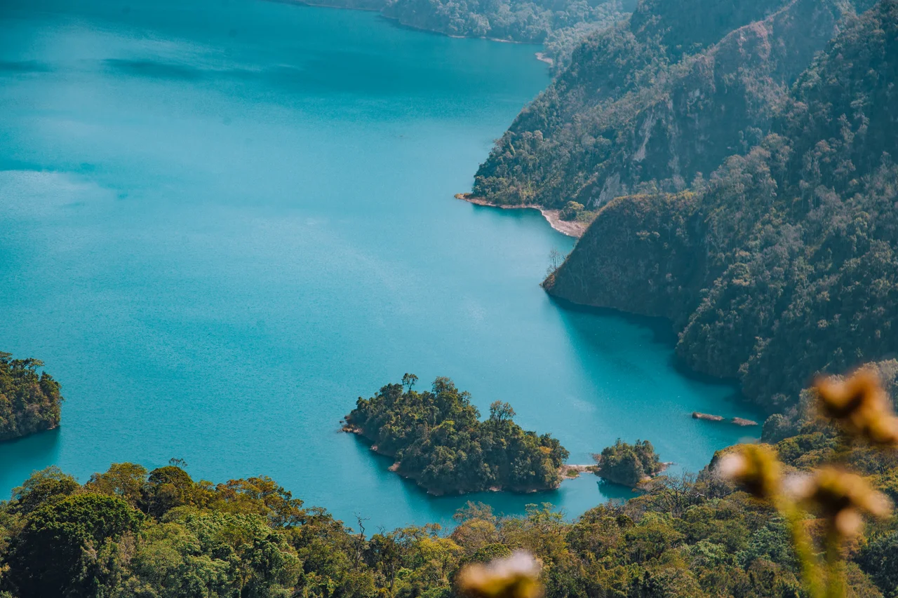
From the Air
Coordinates: 8.50°S, 33.00°E, in Tanzania's Southern Highlands. Elevations range dramatically from 475m at Lake Nyasa up to 2,900m at Mount Rungwe's summit. The Great Rift Valley runs through the region - look for Lake Nyasa to the south and Lake Rukwa to the north-west at cruise altitude. Songwe International Airport (HTGW) near Mbeya is the main regional hub. Weather in the rainy season (October-May) can include severe convective buildups over the mountains.
Nearby Stories
- Mbeya 14 km away
- Songwe Region 35 km away
- Ngualla 62 km away
- Mount Rungwe 74 km away
- Mbala, Zambia 108 km away
- Rukwa Region 115 km away
- Kalambo structure 122 km away
- Ruaha National Park 159 km away