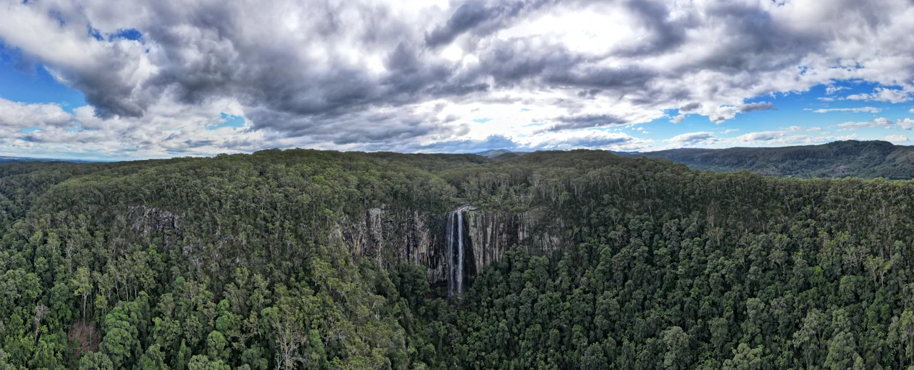

Minyon Falls
The water arrives at the edge almost casually. Repentance Creek winds through wet forest, unremarkable, and then the ground simply stops, and the stream leaps into a hundred metres of open air. It falls past a sheer wall of rhyolite - rock that cooled from lava some 23 million years ago, in the heart of the volcano that once towered over this whole corner of New South Wales. Below, the rainforest swallows the spray. Minyon Falls is the moment a quiet creek discovers the bones of a dead volcano, and the drop has been measured at anywhere from 97 to 104 metres depending on who is holding the tape.
The Volcano's Edge
These cliffs are a relic of the Tweed shield volcano, a vast dome of lava that erupted around 23 million years ago and has since been carved by erosion into a ring of escarpments. At its centre, far to the north, the jagged spire of Mount Warning - Wollumbin to the Bundjalung - is the eroded plug that once fed the eruptions. Rhyolite is hard, fine-grained, and stubborn. It resists the creek where softer rock would crumble, which is why the water does not gnaw a gentle descent but plunges clean off the lip. Stand at the lookout and you are perched on the rim of an ancient caldera, gazing across a valley that the volcano's collapse and millions of years of rain have hollowed from the land. The same geology shapes the whole hinterland behind Byron Bay, but nowhere does it announce itself as dramatically as here, where a hundred metres of cliff lay the volcano's anatomy bare.
A Rainforest That Was Saved
Minyon Falls lies within Nightcap National Park, part of the Gondwana Rainforests of Australia, inscribed on the World Heritage list in 1986. That protection was hard-won. In 1979, just to the west at Terania Creek, a group of locals stood in front of Forestry Commission bulldozers to stop the felling of brushbox trees more than a thousand years old. It was the first direct-action forest blockade in Australia, the protest that helped end rainforest logging across the state and led to the park's declaration. The towering trees in this valley survive because people once refused to let them fall.
Who Lives in the Valley
There are really two forests here. The clifftop is wet sclerophyll - tall, straight blackbutt, tallowwood, and flooded gum reaching for the light - while below, where the spray keeps the air damp, it gives way to true subtropical rainforest: a tangle of bangalow palms, strangler figs, tree ferns, and blue quandong, with the cool corridor of Repentance Creek threading through it. Lace monitors haul themselves up trunks; satin bowerbirds and noisy pittas flicker in the understorey; peregrine falcons ride the updraughts off the cliff. Lucky visitors glimpse Albert's lyrebird, a koala, or a pademelon slipping into the brush. Carpet pythons drape the branches. And in wet weather, the leeches come out in force - a small toll the rainforest exacts from anyone who walks its trails.
Walking to the Bottom
A fifty-metre boardwalk leads to the main lookout, wheelchair accessible, where most visitors take in the falls from above, with picnic tables and barbecues set among the trees at the clifftop. But the valley rewards the determined. A 4.5-kilometre track drops from the rim, crosses the ridge near Quandong Falls, and descends to the plunge pool at the base before looping back through the clearing called Minyon Grass - a route of steep grades and slippery rock scrambles. Camping is not allowed at the falls themselves, but a campground waits two kilometres west at Rummery Park, linked to the top of the falls by the gentle Boggy Creek Walk. The access road is unsealed and rough. And there is no guarantee of a torrent: Repentance Creek, once called Boggy Creek, can dwindle in dry spells until the pool turns murky and unswimmable. Come after rain, and the cliff roars.
From the Air
Minyon Falls sits at 28.61 degrees south, 153.39 degrees east, in Nightcap National Park west of Byron Bay. The white ribbon of water against the dark rhyolite cliff and surrounding rainforest makes a striking visual reference when flowing, though it can shrink to a trickle in drought. Recommended viewing altitude 2,000 to 3,500 feet to take in the escarpment and forested valley. Nearest airport is Lismore (ICAO YLIS), roughly 25 km south; Ballina Byron Gateway (YBNA) is about 35 km southeast and Gold Coast (YBCG) around 90 km northeast. Terrain is steep and forested - expect orographic cloud and rapidly changing visibility over the ranges, especially in moist easterly flows.
Nearby Stories
- Richmond River Massacres 7.2 km away
- Fingal Head Light 16 km away
- Spicers Gap Road 56 km away
- Allan Cunningham Monument 78 km away
- Washpool National Park 83 km away
- HMS Porpoise (1799) 693 km away
- Wreck Reefs 722 km away
- SS Elingamite: Gold, Fog, and a Captain Wrongly Blamed 1809 km away