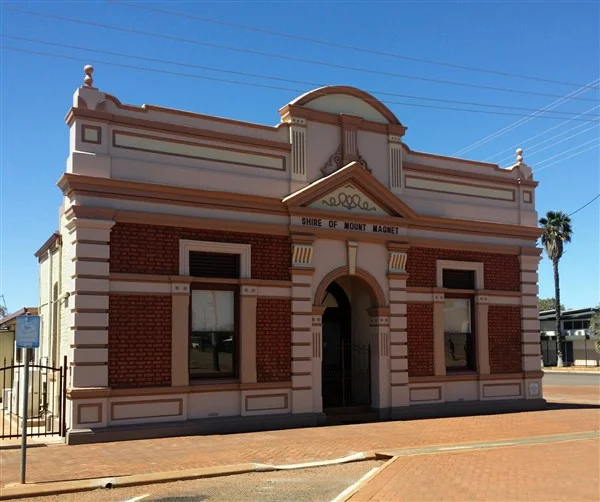

Mount Magnet, Western Australia
When the surveyor Robert Austin crossed this country in 1854, his compass lied to him. The needle swung and drifted, thrown off by the iron locked inside a prominent hill, and so he named the rise West Mount Magnet for the very rock that was confusing his instruments. The name stuck, even as the hill itself recovered its older identity. There is a final irony hidden in the geology: at Mount Magnet today, magnetic north and true north line up exactly. The magnetic variation is zero. The hill that once bent a man's compass now points perfectly straight.
Gold Dug Up Like Potatoes
The reason a town grew beneath the hill came in July 1891, when prospectors struck rich reef gold on the eastern flank of the mount. At a spot still called Poverty Flats, alluvial nuggets lay so thick that diggers said they were pulled from the ground like potatoes. The rush that followed scattered three separate townsites across the area: Mount Magnet itself, Boogardie, and Lennonville. Lennonville was abandoned at the outbreak of the First World War, and the foundations of its bank and railway station still sit empty in the scrub. Boogardie was swallowed whole by the open-cut pits of the Hill 50 mine. Of the three, only Mount Magnet endured, and it has kept going long enough to become the longest-surviving gold-mining town in all of Western Australia.
Warramboo, the Camping Place
Long before the surveyors and the diggers, this was a gathering place, and the land remembers it. In 1972 the Surveyor General restored the hill's Aboriginal name, Warramboo, meaning campfire camping place, a quiet acknowledgement of who was here first and what the rise had always meant. Northeast of town lie significant Aboriginal sites, now cared for jointly by the local community and the Western Australian Museum, and the living culture of the region is carried on at the Wirnda Barna Arts Centre. The country that drew the gold rush had been a meeting ground for far longer than any mine has operated, and it remains one.
The Granites
A short drive from town stands one of the Murchison's most striking landmarks. The Granites are a low escarpment, roughly fifteen metres high, where soft white granite has eroded out from beneath a hard rust-red iron cap, leaving sculpted hollows and shallow caves with surfaces curled and grooved by veins of quartz. To the Badimia people the place holds deep cultural significance, and their old paintings and carvings can be found at several sites among the rocks. At dawn and dusk the red caprock catches the light and seems to glow above the pale stone beneath, a natural amphitheatre that has drawn people, for ceremony and for wonder, far longer than the town has stood.
The Junction Years
Mount Magnet owed much of its staying power to steel. When the Northern Railway pushed up through the Murchison toward Meekatharra, the town became an important junction, the point where the Sandstone branch line split off to serve the fields further east. Trains meant the difference between a flash-in-the-pan rush and a town that lasted: ore could leave, supplies could arrive, and people could come and go without days of hard travel across waterless scrub. The line is long closed now, lifted and sold off like most of the Murchison railways, but the town it anchored kept going. Mount Magnet is still served by air, with Skippers Aviation flying in and out to Perth and Meekatharra, a modern echo of the old role as the place where the wider world reached the goldfields.
A Wide Street and a Stubborn Town
Walk Mount Magnet's main street and the gold-rush ambition is still legible in its width. Unusually for a community this size, the town never built its own public stamp battery to crush ore; the nearest stood five kilometres west at Boogardie, and it now sits in the Mount Magnet Mining and Pastoral Museum. The mines, though, never really stopped. Today Ramelius Resources works the pits with names borrowed from the heavens, Saturn, Mars, the Galaxy area, and the Perseverance cutback atop the old Hill 50 underground workings. Come the wildflower season from August to November, the surrounding plains erupt in scarlet Sturt's desert pea, royal-purple mulla mulla, and drifts of pink and yellow everlastings, briefly turning the hard goldfields country into something soft and luminous.
From the Air
Mount Magnet sits at roughly 28.06°S, 117.85°E in the Mid West of Western Australia, on the Great Northern Highway about 560 km north-northeast of Perth. From the air, look for the namesake iron-rich hill (Warramboo) beside the town, the unusually wide main street, and the scars of open-cut gold workings, including the Hill 50 and Galaxy pits, just to the northwest. The town is served by Mount Magnet Airport (YMOG), with Skippers Aviation flights to Perth and Meekatharra. The climate is hot desert (Köppen BWh); skies are typically clear, with the hottest day on record reaching 47.4°C in January 2015, so expect heat haze and turbulence on summer afternoons.
Nearby Stories
- Austin, Western Australia 17 km away
- Dalgaranga crater 20 km away
- Mullewa–Meekatharra railway 73 km away
- Sandstone Gold Mine 76 km away
- Yarrabubba 78 km away
- The Great Emu War: When Australia Lost a War to Birds 369 km away
- 7 Naval Ammunition Depot 388 km away
- 2021 Wooroloo Bushfire 418 km away