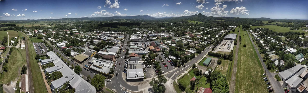

Mullumbimby
The slogan is half a joke and half a dare: "The Biggest Little Town in Australia." Mullumbimby has fewer than 4,000 people, a single broad main street, and a way of looming much larger than its size suggests. Locals shorten the name to "Mullum" and wear the town's reputation lightly. Set in the green folds of the Brunswick Valley, nine kilometres from the coast yet a world away from the surf brochures of nearby Byron Bay, it is a place where dairy country, rainforest remnants and a stubborn streak of counterculture have grown together into something genuinely its own.
Beneath the Sister Mountain
Rising over the town is Mount Chincogan, a steep volcanic plug that the Bundjalung people hold as a sacred women's site, sister to the men's site of Wollumbin, the peak Europeans later called Mount Warning. Both are eroded remnants of an ancient shield volcano that once dominated this corner of the continent. The town's name belongs to the Bandjalung-Yugambeh language, from a word meaning "small round hill." Curiously, scholars think Chincogan is too prominent to be the hill in question. The name may instead point to a humbler rise nearby, or to the open grassy flats known as Mullumbimby Grass, long used by Bundjalung people as hunting grounds before bullock teams ever grazed there.
Cedar, River and Bullock Teams
Mullumbimby began as a timber town. In the 1850s, Europeans camped where two arms of the Brunswick River met, drawn by the prized red cedar of the "Big Scrub," the vast lowland rainforest that once blanketed this region. The town's location was no accident. The river was tidal and navigable to exactly this point, so felled logs could be floated downstream to the sea at Brunswick Heads, and the spot offered firm ground for bullock teams to cross with their loaded wagons. At low tide you can still see the shallows beneath today's Federation Bridge where the bullocks once forded. The cedar-getters took the best of it and moved on. Once the great cedars were gone, the timber trade collapsed, the land was handed out on the condition it be cleared for farming, and Mullumbimby settled into a steadier life of beef, dairy, bananas and sugar cane.
Light from a Mountain Creek
For a brief moment, this farming town was an electrical pioneer. Drawing water from a weir on nearby Wilsons Creek, a small hydro-electric scheme designed by engineer William Corin began switching on the lights in December 1925 and entered official service in March 1926. It was the fourth hydro station in New South Wales and only the fifth on mainland Australia, making Mullumbimby one of the first country towns in the state with electric power. The scheme lit not just Mullumbimby but Byron Bay and Bangalow as well. The site at Laverty's Gap, near the old powerhouse, is once again being eyed for energy, this time as a possible pumped-storage hydro project.
The Biggest Little Reputation
From the 1970s onward, Mullumbimby and the wider Byron Shire became a magnet for alternative living, and the town never looked back. It is the kind of place where a male choir called Dustyesky sings Russian folk songs well enough to earn coverage on Russian national television, and where a weekly farmers' market has become a community institution. The town's free-thinking streak has a sharper edge too: Mullumbimby has drawn national attention as a centre of vaccine scepticism, recording some of the lowest childhood immunisation rates in Australia. Among those who grew up here is the rapper Iggy Azalea, who took her stage name in part from Mullumbimby's own Azalea Street, where her childhood home stood. The town has a knack for producing the unexpected, and for wearing its contradictions without apology.
From the Air
Mullumbimby sits at 28.55°S, 153.50°E in the Brunswick Valley of far-northern New South Wales, about 9 km inland from the coast at Brunswick Heads. The unmistakable cone of Mount Chincogan rises just north of town and makes an excellent visual landmark, with the larger Nightcap Range and the dramatic spire of Wollumbin (Mount Warning) to the west and north-west. Recommended viewing altitude is 3,000–5,000 ft for the valley-and-mountain context. The nearest airports are Ballina Byron Gateway (YBNA) about 35 km south and Gold Coast Airport (YBCG) about 50 km north. Expect summer humidity, afternoon thunderstorms and the heavy rainfall typical of this green hinterland.
Nearby Stories
- Richmond River Massacres 7.2 km away
- Fingal Head Light 16 km away
- Spicers Gap Road 56 km away
- Allan Cunningham Monument 78 km away
- Washpool National Park 83 km away
- HMS Porpoise (1799) 693 km away
- Wreck Reefs 722 km away
- SS Elingamite: Gold, Fog, and a Captain Wrongly Blamed 1809 km away