
Mỹ Sơn
King Bhadravarman I, who ruled Champa from 381 to 413 AD, had a request for his successors. He inscribed it on a stele at the valley of Mỹ Sơn after dedicating the site to his god: "Out of compassion for me do not destroy what I have given." He added a karmic warning for good measure. His successors listened. For nine centuries, Cham kings returned to this narrow mountain valley to renovate older temples and build new ones, making it the religious heart of their civilization. What fire, invasion, and the decline of Champa had spared, a week of American bombing in 1969 largely erased. What remains is still remarkable — recognized as a UNESCO World Heritage Site in 1999, still being painstakingly restored by scholars from Poland, India, Germany, and Japan. But Bhadravarman's plea, written sixteen centuries ago, reads now like a prophecy that arrived too late.
The Valley the Cham Chose
Mỹ Sơn sits in a valley roughly two kilometers wide, enclosed by two mountain ranges, about 68 kilometers southwest of Da Nang and 36 kilometers south of Hội An. The Cham people knew this landscape as a place apart — sheltered, symbolically resonant, cut off from the rice plains by ridgelines that made it feel like a world within the world. From the 4th to the 13th century, it served as the religious and ceremonial center of Champa, the Indianized Hindu kingdom that once stretched across much of central and southern Vietnam. Kings were buried here. National heroes were commemorated. The god Shiva was venerated under the name Bhadreshvara — a composite of Bhadravarman's own name and the Sanskrit word for lord — ensuring that royalty and divinity were woven together at the site's very foundation. At its height, the complex contained over 70 temples and numerous steles inscribed in both Sanskrit and old Cham.
Fire, Invasion, and Rebuilding
The original temples Bhadravarman built were wood — timber logs shaped into sacred halls. In 535 or 536 AD, during the reign of King Rudravarman I, fire consumed them entirely. His son Sambhuvarman, who ruled from 572 to 629, rebuilt the complex in brick and reinstalled the god under a new combined name: Sambhu-Bhadresvara. The stele he erected declared this deity "the creator of the world and the destroyer of sin." Sambhuvarman's reign was also marked by catastrophe from without: in 605 AD, the Chinese general Liu Fang led an army south, defeated the Cham elephant-riders, sacked the capital, and carried off over a thousand Buddhist books along with the gold tablets commemorating the previous eighteen kings. Liu Fang's invaders were struck by epidemic on the way home and many died, including the general himself. Sambhuvarman returned, rebuilt again, and kept the tribute flowing to China. This pattern — devastation followed by reconstruction, foreign pressure answered with resilience — repeated itself across Champa's long history at Mỹ Sơn.
The Architecture That Puzzles Scholars
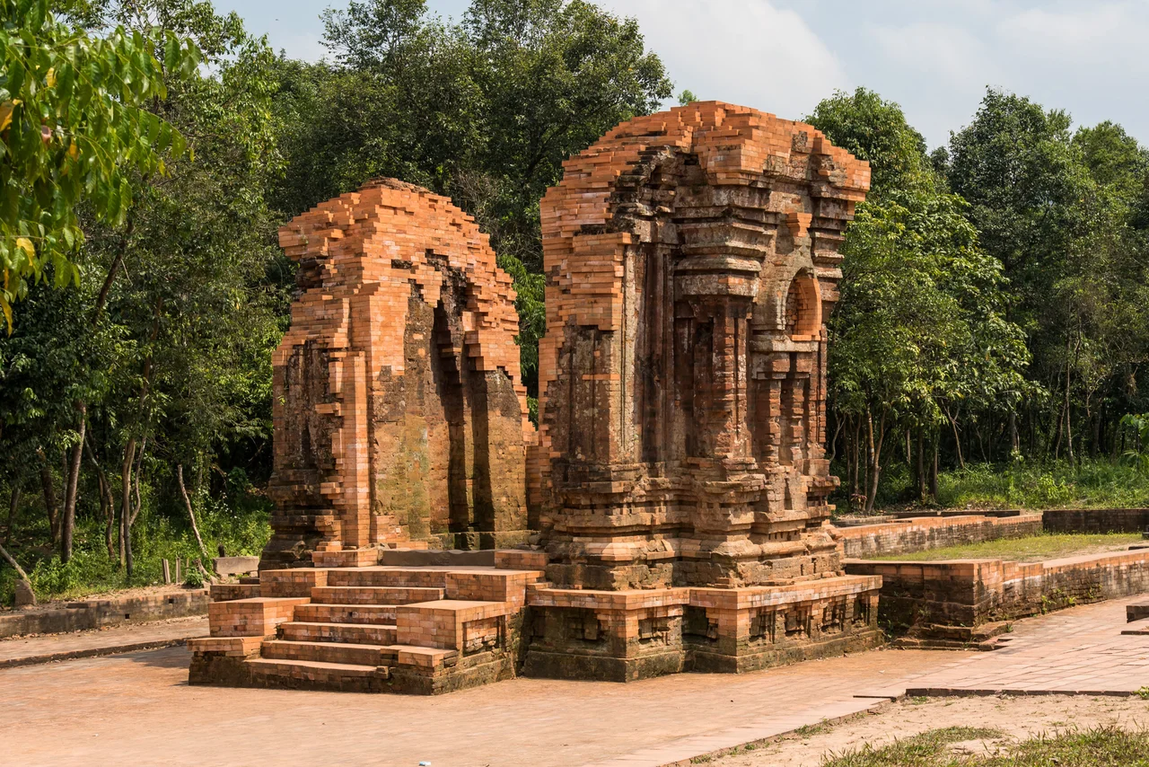
Nearly all the buildings at Mỹ Sơn were built from red brick, and their construction methods still confound researchers. The decorative carvings were cut directly onto the finished brick walls — not onto sandstone inserts, as other regional temple builders practiced — and the mortar that once held them together has so thoroughly decayed that strong winds can now dislodge individual bricks. Whether the brick structures were fired before or after assembly remains unresolved; evidence points both ways. Seven distinct architectural styles developed at Mỹ Sơn across the centuries, two of which originated here: the Mỹ Sơn E1 Style of the 8th century and the Mỹ Sơn A1 Style of the 10th. The great tower known simply as "A1" — once the architectural masterpiece of the Cham — is now a mound of earth surrounded by rubble, destroyed by bombing. A scale model built by Japanese researchers allows visitors to understand what was lost.
Rediscovery and Destruction
After the Cham lost their northernmost territories to the Viet in the early 15th century, Mỹ Sơn fell into the forest and was largely forgotten. It was rediscovered in 1898, and by 1904 scholars of the École française d'Extrême-Orient had published their first findings in detail. French conservators began restoration work in 1937 and continued through 1943. Then came the Vietnam War. During a single week of bombing in August 1969 — the temples had been used as a base area by North Vietnamese and Viet Cong forces — American aircraft destroyed the majority of what had stood for centuries. What the kings of Champa had built across nine hundred years, and what French scholars had begun carefully to restore across six, was largely gone within days. The surrounding land remains dangerous from unexploded ordnance.
The Long Work of Restoration
Since 1981, the work of piecing Mỹ Sơn back together has been international. Polish conservators from Lublin, led by Kazimierz Kwiatkowski, spent decades on the site. Germany and Poland funded an in-situ museum. Italy and Japan backed UNESCO conservation plans. Between 2017 and 2022, India's Archaeological Survey restored the A, H, and K temple groups at a cost of US$2.25 million, completing the work in December 2022 — a project rooted in the cultural connections between Indian and Cham civilization that date to the site's founding. Mỹ Sơn received UNESCO World Heritage status in 1999 under criteria that recognized it both as evidence of cultural evolution and as the legacy of a civilization now extinct. What visitors find today are brick towers half-reclaimed by the forest, carvings that took scholars a century to begin to understand, and a stele inscription from a 4th-century king asking posterity for something history could not guarantee.
From the Air
Mỹ Sơn lies at 15.763°N, 108.124°E, in a mountain valley approximately 68 km southwest of Da Nang. From a light aircraft at 6,000–9,000 feet, the valley is visible as a forested bowl enclosed by ridgelines; the temple groupings are partially obscured by canopy. The nearest airport is Da Nang International (VVDN), about 70 km to the northeast. Hội An is approximately 36 km to the east-northeast. The site sits at roughly 100 meters elevation; surrounding ridges reach 500–700 meters. Afternoon cloud buildup is typical in the rainy season (September–January). The valley can be identified by the Thu Bồn River drainage to the east.
Nearby Stories
- Chu Lai Air Base 11 km away
- Da Nang Air Base 11 km away
- Battle of FSB Mary Ann 18 km away
- Chàm Islands 25 km away
- Operation Hong Kil Dong 36 km away
- Dong Ampham National Biodiversity Conservation Area 43 km away
- Tomb of Tự Đức 49 km away
- A Sầu Valley 70 km away