The Pepper Kingdom's Ghost
In 1596, a hundred thousand people lived inside the walls. Canals threaded between neighborhoods. Aqueducts carried clean water from an artificial lake through underground pipes and treatment stations to the palace district. Foreign merchants -- Chinese, Indian, Arab, Portuguese, Dutch -- crowded the waterfront outside the walls, segregated by faith: Muslims to the northeast, non-Muslims to the west. Pepper made all of it possible. Today, the walled city of Banten is a village with squatters occupying the gaps between archaeological ruins, and the only building still standing within the old walls is a mosque. The collapse of Old Banten is one of the most complete urban disappearances in Southeast Asian history.
Built on Pepper and Defiance
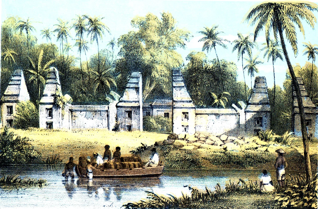
Banten rose as a port city in the 16th century after the fall of the Demak Sultanate, becoming the preeminent pepper-trading center of the Indonesian archipelago. The Banten Sultanate controlled the trade that European merchants crossed oceans to reach, and the city's wealth was staggering. But pepper attracted the Dutch East India Company, and the VOC did not negotiate when it could dominate. The conflict between Banten's sultans and the Dutch stretched across decades, culminating in a Dutch military intervention during the reign of Sultan Ageng Tirtayasa in 1680. The Dutch destroyed the Surosowan Kraton, the royal palace built in 1552, reducing it to foundation walls of red stone and coral. What the 17th century began, the 19th century finished: in 1832, the colonial governor Daendels ordered the destruction of the Kaibon Kraton, the palace of Queen Ratu Aisyah, partly because the Sultanate of Banten -- unlike its counterparts elsewhere in Indonesia -- had never submitted to colonial authority. The Dutch did not just defeat Banten. They dismantled it.
A City Engineered by Water
The sophistication of Banten's infrastructure challenges assumptions about pre-colonial Indonesian cities. Transport within the walls was primarily waterborne -- rivers, canals, and bridges formed the city's circulatory system. South of the walled area, the sultanate constructed Tasik Ardi, a rectangular artificial lake spanning five hectares that served as the city's water reservoir. From this lake, water flowed through a series of treatment stations, then through pipes and viaducts into the city proper. Some of these treatment stations remain visible today, their stone basins sitting in overgrown fields south of the old walls. The city's layout followed Javanese rather than local Sundanese urban planning traditions: a mosque facing an alun-alun, the open square that anchors every classical Javanese city, with the shahbandar's compound -- the harbor master who regulated all foreign trade -- positioned on the alun-alun's eastern edge.
Walls Within Walls
Old Banten was a city of careful separations. The area inside the walls divided into northern and southern halves, with the elite residential compounds and the palace complex concentrated in the north. Only Indonesians could live within the city walls. Foreigners were consigned to neighborhoods outside, arranged by religion along the shoreline. This was not xenophobia but commercial strategy -- foreign merchants were essential to Banten's economy, and placing them near the port kept trade flowing while reserving the walled city for the sultanate's own people. The Surosowan Kraton's ruins still show this logic. The palace compound enclosed a rectangular pleasure pool, similar in concept to the famous bathing pools of Yogyakarta's Taman Sari, where the royal family retreated from the heat and the noise of a city that hummed with commerce from dawn until dark.
Many Faiths, Many Towers
The Great Mosque of Banten, the only surviving structure within the old walls, is the most visible reminder of the city's cosmopolitan past. Its architecture blends Javanese, Chinese, Portuguese, and Dutch influences -- a minaret shaped like a lighthouse, a study hall designed by a Dutch convert to Islam, columns decorated with Buddhist lotus motifs. But the Great Mosque was not alone. Scattered around Old Banten are the remains of other mosques: Masjid Kanari, the ruined tower of Masjid Pecinan Tinggi, and the demolished mosque of Kraton Kaibon. Outside the walls, the Kasunyatan Mosque served as an Islamic academy. And tucked among these Islamic structures sits the Avalokiteshvara Vihara, one of the oldest Chinese Buddhist temples in Indonesia -- evidence that Banten's sultans tolerated religious diversity within their predominantly Muslim city. Fort Speelwijk, the Dutch fort built in 1682 near the Great Mosque, adds a final architectural layer. A European cemetery lies to its southeast, its headstones marking the other side of the colonial story.
Pilgrims and Ruins
Old Banten has been proposed for UNESCO World Heritage status since 1995, but the designation has not materialized, and conservation remains inconsistent. The Great Mosque is well-maintained by its worshippers, but the surrounding ruins receive far less attention. What draws most visitors is not archaeology but devotion. Pilgrims come to pray at the tombs of Sultan Maulana Hasanuddin, who founded the sultanate, and his descendants. They come to the museum between the Surosowan Kraton and the Great Mosque, where a 2.5-meter Ottoman cannon called Meriam Ki Amuk and a stone pepper mill sit among ceramic vases and coins -- artifacts from a city that once processed more pepper than any port in the archipelago. The contrast is stark: a place that housed a hundred thousand people, engineered its own water supply, and defied a European empire, now reduced to scattered walls and a single magnificent mosque. But the pilgrims keep coming. In a country where the past is built over as quickly as it crumbles, the act of remembrance is itself a form of preservation.
From the Air
Located at 6.04S, 106.16E on the northern coast of Java's Banten province, approximately 11 km north of modern Serang. The archaeological site stretches along the coast with the Great Mosque of Banten's distinctive tiered roof and minaret as the primary visual landmark. Tasik Ardi lake is visible to the south. Nearest major airport is Soekarno-Hatta International (WIII) approximately 80 km east. The terrain is flat coastal plain. The Sunda Strait is visible to the west, with Sumatra beyond.
Nearby Stories
- Anak Krakatoa 6 km away
- Four Minutes Over the Java Sea 13 km away
- The Golden Domes of Depok 28 km away
- Ujung Kulon National Park 49 km away
- Lion Air Flight 610 66 km away
- The King's Footprints in the River 80 km away
- 1933 Sumatra Earthquake 99 km away
- Way Kambas National Park 100 km away