
Operation Masher / White Wing
The operation was called Masher. Then President Lyndon Johnson saw the name and ordered it changed — it sounded too violent, he said, for what America was doing in Vietnam. So on 4 February 1966, it became Operation White Wing, and the largest search-and-destroy mission conducted in the war up to that point continued under a more palatable name. The soldiers doing the fighting called it Masher anyway. The name change did not alter what the operation was, what it cost, or what it failed to accomplish.
A Province 'Just About Lost'
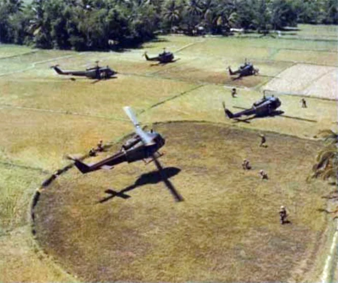
By January 1966, a CIA report had concluded that Bình Định Province on South Vietnam's central coast was 'just about lost' to communist forces. The assessment was not hyperbole. The People's Army of Vietnam's 3rd Division — two regiments of North Vietnamese regulars and one regiment of main-force Viet Cong guerrillas — controlled much of the province's land and much of its population of roughly 800,000. The Bồng Sơn plain, the coastal lowlands where most people lived and farmed, was largely under North Vietnamese influence. The South Vietnamese government's authority existed primarily on paper and in provincial capitals. Into this situation the 1st Cavalry Division (Airmobile) was ordered to conduct a campaign of hammer-and-anvil airmobile assaults — helicopters inserting troops to flush the North Vietnamese toward blocking positions — intended to break the PAVN 3rd Division's grip on the province.
The Hammer and the Anvil
General Harry Kinnard assigned the mission to Colonel Hal Moore's 3rd Brigade, the same commander who had led the 1st Cavalry at the Battle of Ia Drang three months earlier. The plan had two phases. First, a brigade-size task force would establish a forward base at Phu Cat on Highway 1 and patrol ostentatiously, as if the real target were elsewhere. Then the division would shift north to Bồng Sơn itself and launch a series of airmobile operations across the plain and into the An Lão Valley, where Kinnard believed the PAVN 3rd Division's headquarters was located. On January 28, Operation Double Eagle — the largest amphibious assault of the Vietnam War since Korea — sent U.S. Marines ashore to push south from Quảng Ngãi province, theoretically trapping PAVN forces between two advancing forces. The Marines found few enemy soldiers. The main force regiments had withdrawn days before the landing.
Six Civilians for Every Combatant
Operation Masher lasted from January 24 to March 6, 1966. Its commanders declared it a success, citing significant losses inflicted on the PAVN 3rd Division. But intelligence reports a week after the 1st Cavalry withdrew showed North Vietnamese soldiers already returning to the areas they had vacated. The discrepancy between weapons recovered and bodies counted raised questions about how many of the dead were actually combatants. An American journalist who visited a refugee camp housing 6,000 people displaced by the operation found them packed thirty to a room, receiving inadequate food and medical treatment, 'in a sullen and depressed mood.' Under the rules of engagement then in effect, anyone in a free-fire zone who did not leave voluntarily could be treated as Viet Cong. An unknown number of civilians died. During the subsequent Fulbright Hearings in the U.S. Senate, testimony alleged that for every PAVN or Viet Cong casualty reported, six civilian casualties had also occurred. The allegation helped accelerate growing public opposition to the war at home.
The Question Masher Couldn't Answer
Bình Định Province would be fought over repeatedly in the years that followed. The same terrain, the same villages, the same coastal plain between Highway 1 and the South China Sea — Operation Washington Green would spend nearly two years there from 1969 to 1971, the Battle of Tam Quan would erupt in December 1967, and the Bồng Sơn plain would remain contested ground until the war's end. Operation Masher/White Wing demonstrated the central tension of the American strategy in Vietnam: the 1st Cavalry could clear any area it chose to enter, but it could not hold what it cleared. Clearing required firepower. Holding required legitimacy. The operation's name change, ordered because the original sounded too harsh, captured something true about the war's management: those in charge understood, on some level, that what was happening was difficult to defend. They changed the name. They did not change the operation.
From the Air
Operation Masher/White Wing was centered on the Bồng Sơn plain near 14.53°N, 109.02°E in Bình Định Province, on Vietnam's central coast. At 4,000–6,000 feet altitude, the flat agricultural lowlands along Highway 1 are clearly visible, bounded to the west by the An Lão Valley highlands where the PAVN 3rd Division maintained its base areas. Phu Cat Airport (VVPC) lies approximately 25 km to the south and served as a U.S. forward logistics base during the operation. The coastline of the South China Sea is visible to the east in clear conditions. The terrain here — open rice paddies interrupted by village tree lines and narrow ridges — determined the hammer-and-anvil tactics the 1st Cavalry used throughout the campaign.
Nearby Stories
- Phù Cát Air Base 34 km away
- Kon Ka Kinh National Park 34 km away
- Battle of Mang Yang Pass 49 km away
- Batangan Peninsula 55 km away
- Battle of Hill 488 74 km away
- Battle of the Paracel Islands 284 km away
- Hainan Island Incident 389 km away
- Kashmir Princess 437 km away