
Batangan Peninsula
The name translates as the Three Villages of Peace — ba làng, three villages, and an, the Chinese character for peace, the same character Confucian tax collectors gave to the fishing settlements that once made their living from these rich coastal waters. By the time American forces arrived, the peninsula jutting into the South China Sea southeast of Quảng Ngãi was anything but peaceful. It had become one of the most heavily fortified pieces of ground in Vietnam, and the people who had lived there for generations were caught between forces that had little interest in what they had named this place.
Three Villages of Peace
The Ba Làng An Peninsula lies 32 kilometers south of Chu Lai, pushing eastward into the South China Sea as a flat, fertile thumb of land — approximately 48 square kilometers of farmland and rolling hills, productive enough that French colonial surveys in the 1930s noted its relative agricultural richness. The three villages that give the peninsula its name are Vân An, An Chuẩn, and An Hải, each carrying the Sino-Vietnamese character for peace in their names.
The French knew the cape as Batangan — a phonetic mispronunciation that stuck through the American war and into the historical record, though Vietnamese sources consistently use Ba Làng An. French ships used the cape as a navigational departure point for the long eastward run to the Paracel Islands, carrying supplies to weather stations and settlers. The waters off the peninsula were recognized as some of the richest fishing grounds on the central coast. For most of its history, this place meant fish and rice and the kind of ordinary continuity that most people, everywhere, are actually trying to live.
Fortified Stronghold
By 1963 the Viet Cong had recognized what any military planner could see on a map: the peninsula's narrow land approaches made it naturally defensible, and its coastal location gave it supply access that was difficult to interdict. They converted Ba Làng An into a fortified stronghold, constructing interlocking field fortifications — reconnaissance photographs later showed a V-shaped network of trenches pointing inland, open end toward the sea, with a second V under construction further inland.
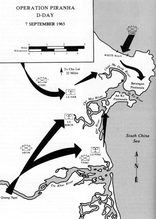
After Operation Starlite in August 1965, Marine intelligence assessed that the 1st VC Regiment had withdrawn into the peninsula. Operation Piranha followed in September 1965, with US Marines, South Vietnamese troops, and Vietnamese Marines landing on the peninsula in a combined assault. American commanders claimed 178 Viet Cong killed and 360 captured or detained. The peninsula subsequently passed through the operational responsibility of a Korean Marine brigade, then the Americal Division, but despite periodic operations it remained contested ground. The village of My Lai, five kilometers to the southwest, would become the site of the war's most notorious atrocity in March 1968.
The Weight of Bombardment
By 1969, the years of sustained bombardment had reshaped how the civilians of Ba Làng An Peninsula actually lived. People had largely moved underground. Families sheltered in bunkers and caves, emerging to tend what crops they could between airstrikes and artillery. The landscape they had known was pocked with craters and laced with mines and booby-traps the Viet Cong had laid against the Marines.
When Operation Bold Mariner landed in January 1969 — the Marine Corps' largest amphibious assault since the Korean War — the Marines evacuated the peninsula's civilian population for screening, eventually moving some 11,900 people. They were sheltered at a relocation facility near Quảng Ngãi City while Marines and Army forces cleared what had been their home. The population was allowed to return in April 1969, together with South Vietnamese government institutions, to a peninsula now crisscrossed with new roads and rebuilt hamlets. North Vietnamese sources made allegations that American forces used gas against civilians during mopping-up operations; these allegations were raised in the French Senate in 1969 and were not resolved.
A Colonel in a Minefield
In May 1970, a patrol from the 1st Battalion, 6th Infantry Regiment walked into a minefield on the peninsula. Soldiers were down, and the situation was what military planners call a casualty-producing event with no easy solution: to reach the wounded, someone had to cross the same field that had just wounded them.
By his own subsequent account, the battalion commander, Lieutenant Colonel Norman Schwarzkopf Jr., flew to the scene in his command helicopter and walked into the minefield himself to reach a wounded soldier. Schwarzkopf would go on to command US Central Command and lead the coalition in the 1991 Gulf War. But in May 1970, he was a lieutenant colonel doing what his men needed him to do on a peninsula that was still, more than five years into intensive American military presence, not yet cleared of its mines.
After the War
During the Easter Offensive of 1972, the Viet Cong 48th Battalion reportedly destroyed 23 villages around the Batangan Peninsula, killing 23 civilians and displacing 30,000 more in an attempt to disrupt South Vietnamese pacification. Among the villages destroyed were two that had been resettled by survivors of the My Lai massacre. The peninsula's civilian population absorbed this loss on top of everything else.
Today the Ba Làng An Peninsula is a productive agricultural region and a growing tourism destination. The beaches are clear and warm; divers come for the underwater visibility. The fishing continues as it always has, from boats heading out into the same waters the French once charted for their supply runs to the Paracels. The fortifications are gone, the craters filled in, the bunkers collapsed or overgrown. The peninsula has returned, more or less, to what its name always promised.
From the Air
Located at 15.22°N, 108.97°E, the Ba Làng An Peninsula projects eastward into the South China Sea southeast of Quảng Ngãi city. From the air, the peninsula is clearly visible as a low, flat landmass distinct from the mainland, with beaches on its seaward faces. My Lai village lies approximately 5 km to the southwest. The nearest airport is Chu Lai (VVCA), approximately 32 km to the north along the coast. Quảng Ngãi Airport (VVQN) lies roughly 15 km to the southwest. Recommended viewing altitude is 3,000–5,000 feet for a clear look at the peninsula's geographic position and coastal character.
Nearby Stories
- War of the Flags 16 km away
- Battle of FSB Mary Ann 22 km away
- Tam Kỳ 37 km away
- Operation Hawthorne 43 km away
- Operation Masher / White Wing 51 km away
- Vũng Rô Bay 231 km away
- Vũng Rô Bay Incident 260 km away
- Battle of the Paracel Islands 271 km away