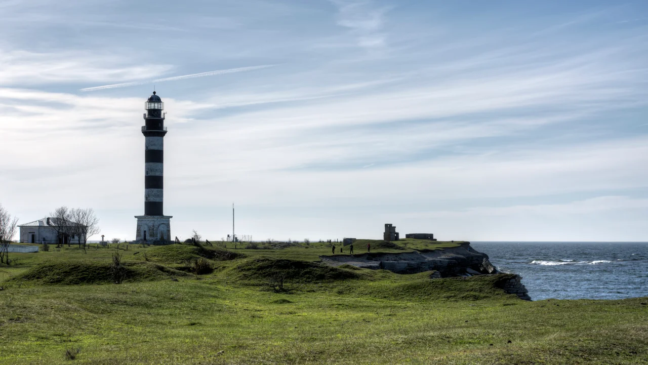

Osmussaar Lighthouse
On 2 December 1941, Soviet soldiers preparing to abandon Osmussaar destroyed the island's lighthouse. It was a deliberate act with obvious military logic: a lighthouse is a gift to whoever holds the sea next, and this one had marked the mouth of the Gulf of Finland since before there was an Estonia to argue about. The stone tower that came down that day was itself a replacement, built in 1850. The one that stands now went up in 1954 - a 35-metre column of reinforced concrete in bold black and white bands, its light 39 metres above the sea. Counting back through the collapses, the demolitions and the improvised wooden stopgaps, Osmussaar is on at least its fifth beacon in two and a half centuries. The island keeps losing its light and keeps rebuilding it, because the alternative is unthinkable to anyone who has to sail past.
Why a Light Belongs Here
Look at where the island sits and the answer is immediate. Osmussaar lies 7.5 kilometres off the Estonian mainland at the very mouth of the Gulf of Finland - the gate through which everything bound for Tallinn, Helsinki, Vyborg and St Petersburg has to pass. It is also almost invisible from the water: a flat limestone slab five kilometres long and barely more than a kilometre wide, rising only a few metres, ringed by shoals and by the shallow banks of an ancient impact crater a short way offshore. A low island in a busy strait is a trap, and the islanders knew it well. Salvaging wrecks was for centuries part of how the community here made its living. The lighthouse exists to end that particular source of income.
Five Towers, Two and a Half Centuries
The first stone beacon went up in 1765. In 1804 it was raised and fitted with a proper lantern room, its light produced by a catoptric apparatus - twenty-four oil lamps, each sitting in front of a polished reflector that gathered the flame's scattered glow and threw it seaward. That structure collapsed in 1814 and a temporary wooden tower stood in for it. A new stone lighthouse followed in 1850, and in 1875 it received the technology that had by then transformed lighthouses everywhere: a dioptric Fresnel apparatus, whose stepped glass rings bend light rather than bouncing it, wasting far less and reaching much further. Electricity arrived in 1902. In under a century the same headland went from twenty-four flames in tin dishes to an electric lamp behind precision-ground glass.
The Island as a Fortress
What ended the 1850 tower was not weather but strategy. In June 1940 the Soviet Union cleared Osmussaar of its inhabitants - about 130 people, overwhelmingly Estonian Swedes whose families had farmed and fished here for some seven centuries - and turned the island into a coastal artillery position, with heavy gun batteries and a sixteen-metre fire-control tower to spot for them. For roughly eighteen months Osmussaar was a gun platform guarding the gulf. When the garrison finally pulled out in December 1941, the sappers took the lighthouse with them on the way. The island stayed in Soviet military hands until 1993.
Concrete and Bands
After the war a temporary wooden tower carried the light again until something permanent could be managed, and in 1954 the current lighthouse was finished on the island's northwestern point. Reinforced concrete, 35 metres tall, focal plane at 39 metres, painted in the broad horizontal black-and-white bands that make a daymark legible against a grey Baltic sky. It is not an old or a beautiful lighthouse by Estonian standards - this is a country that still lights ships with Kopu on Hiiumaa, completed in 1531, and with the 52-metre tower at Pakri from 1889 - but it is the tallest thing for many kilometres in any direction, and it does exactly what the 1765 beacon was built to do.
What the Tower Overlooks Now
The island below the light has gone quiet in a way its builders never anticipated. Since 1996 Osmussaar has been a landscape protection area of some 486 hectares, safeguarding its limestone cliffs, its beach ridges, and the extraordinary breccia boulders thrown out of the Neugrund impact. Some 158 bird species have been recorded here, and the island sits on the East Atlantic flyway, so in migration season the traffic overhead vastly outnumbers anything on the water. Around five people live here year-round. Up to three thousand visitors come out across a summer to walk to the ruined chapel, look at the boulders, and stand under the striped tower. The lighthouse zone remains one of the reserve's restricted areas - still working, still counted as infrastructure, on an island that has otherwise been handed back to the birds.
From the Air
Lighthouse at 59.3036 N, 23.3612 E, on the northwestern point of Osmussaar, Laane County, Estonia. The tower is 35 m tall with a focal plane 39 m above sea level, painted in horizontal black-and-white bands - the single most reliable visual fix in this part of the gulf and visible from well over 10 nm in clear air at 2,000-4,000 ft. Osmussaar itself reads as a flat pale slab about 5 km by 1.3 km, 7.5 km off the mainland at the mouth of the Gulf of Finland; the shallow ring of the Neugrund crater lies a few kilometres east-northeast. Nearest airfields: Amari (EEEI) about 45 km southeast, Tallinn Lennart Meri (EETN) about 80 km east, Kardla on Hiiumaa (EEKA) about 60 km southwest, Helsinki-Vantaa (EFHK) roughly 90 km north across the water. The island is a protected landscape reserve on a major migratory flyway - stay high in spring and autumn.
Nearby Stories
- Russian cruiser Pallada (1906) 2.8 km away
- Haapsalu Castle 16 km away
- Padise Abbey 17 km away
- Finnish minelayer Louhi 19 km away
- Koluvere Castle 21 km away
- Hitis 66 km away
- Saaremaa 75 km away
- Military Museum of Finland 87 km away