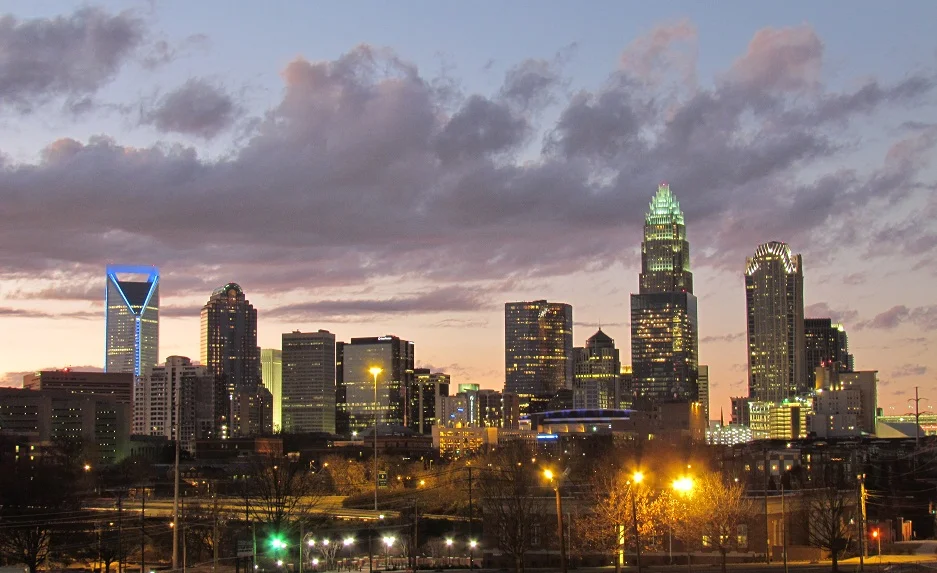

Piedmont Atlantic Megaregion
Drive from Birmingham to Raleigh and you cross what planners now call a single thing - the Piedmont Atlantic Megaregion, sometimes called Charlanta or the Southeast Megalopolis. The interstates I-85 and I-20 are its spine. The cities along them - Birmingham, Atlanta, Greenville, Spartanburg, Charlotte, Winston-Salem, Greensboro, Durham, Raleigh - are knitting themselves together as their suburbs reach for each other across the rolling Piedmont. Roughly 12 percent of the United States population lives here, on land that an earlier generation would have called the Old South and a newer one calls the Sun Belt.
An Emergent Megalopolis
The Regional Plan Association coined the term to describe one of eleven emerging American megaregions, and Georgia Tech and Virginia Tech studies confirmed the pattern. Half the nation's projected population growth and two-thirds of its economic growth are expected to occur within these megaregions over the coming decades. Piedmont Atlantic is the fastest growing of them. The classification matters because the urban centers along I-85 increasingly share watersheds, traffic networks, and labor markets even as they compete for headquarters and conventions. The Piedmont Alliance for Quality Growth has tried to organize mayors and businesses to plan as a region rather than as rival cities, with mixed results. Population density remains comparatively low for a megalopolis, which is what makes it "emergent" rather than fully formed.
On the Old Cotton Land
The Piedmont itself - the rolling hills running 200 to 1,000 feet above sea level between the Appalachian crest and the Atlantic coastal plain - was cotton country in the nineteenth century. That land grew the antebellum South's wealth and absorbed unimaginable human cost. After the boll weevil and the Great Depression broke the cotton economy in the 1920s and 30s, the textile mills that ringed every Southern town became the next economic backbone. Then those collapsed too, as textile manufacturing moved overseas in the late twentieth century. The Atlanta journalist Henry W. Grady's old phrase "New South," originally meant to describe industrial diversification, became literal as the megaregion rebuilt itself on finance (Charlotte is now the nation's second-largest financial center), aerospace and NASA work in Huntsville, biotech and research in the Research Triangle, and BMW, Michelin, and Volvo plants in Upstate South Carolina.
Atlanta, Charlotte, and the Triangle
Three urban poles dominate. Atlanta is the largest metropolitan area, an Alpha-World City by the Globalization and World Cities ranking, anchored by Hartsfield-Jackson, the busiest airport on Earth. Charlotte is the largest single city in the megaregion and the nation's second-largest financial hub after New York. The Research Triangle - Raleigh, Durham, and Chapel Hill - centers on Research Triangle Park, the largest research park in the United States and one of its most prominent technology corridors. Around these poles, second-tier cities have their own gravitational pull: Greenville-Spartanburg-Anderson in Upstate South Carolina, Greensboro and Winston-Salem in the Piedmont Triad, Birmingham at the megaregion's southwestern anchor, Nashville as a contested edge case some studies include and others exclude.
Mountains, Coast, and the Strain Between Them
What makes the Piedmont Atlantic culturally distinct from the rest of the South is also what's straining it. The Appalachian Mountains form its western wall - the Blue Ridge Parkway, Great Smoky Mountains National Park, Mount Mitchell as the highest peak in the eastern United States. The coastal ports of Savannah, Charleston, and Wilmington feed the megaregion's exports. Between them, the I-85/I-20 corridor carries a population that has more than doubled in many counties over a generation. Water rights between Atlanta and downstream Alabama have already gone to court. Traffic congestion in metro Atlanta and Charlotte is among the worst in the country. The infrastructure that growth depends on - power, rail, water, schools - is being asked to do more than it was ever designed for. The megaregion that emerged accidentally is now trying to plan itself, on the fly.
From the Air
The Piedmont Atlantic Megaregion stretches from roughly 32 N to 36 N and 76 W to 87 W, covering parts of Alabama, Georgia, South Carolina, North Carolina, and Tennessee. The I-85 corridor centers near 34 N, 82 W. Cruise altitudes vary by sector - 5,500 to 11,500 feet gives the best appreciation of the linked urban patches. Major airfields include KATL (Hartsfield-Jackson, world's busiest), KCLT (Charlotte Douglas, 17th busiest), KRDU (Raleigh-Durham), KBHM (Birmingham), KBNA (Nashville), KGSP (Greenville-Spartanburg), KGSO (Piedmont Triad), KMEM (Memphis, world's busiest cargo airport). Visual landmarks: the I-85 ribbon threading the urban necklace, the Appalachian wall to the west, and the long arc of mid-sized downtowns from Birmingham to Raleigh.
Nearby Stories
- Battle of Lindley's Fort 20 km away
- Stallings Island 21 km away
- Lake Murray (South Carolina) 22 km away
- Anderson, South Carolina 25 km away
- Kettle Creek Battlefield 26 km away
- Liberty Universalist Church and Feasterville Academy Historic District 31 km away
- Georgia Guidestones 35 km away
- Orangeburg Massacre 71 km away