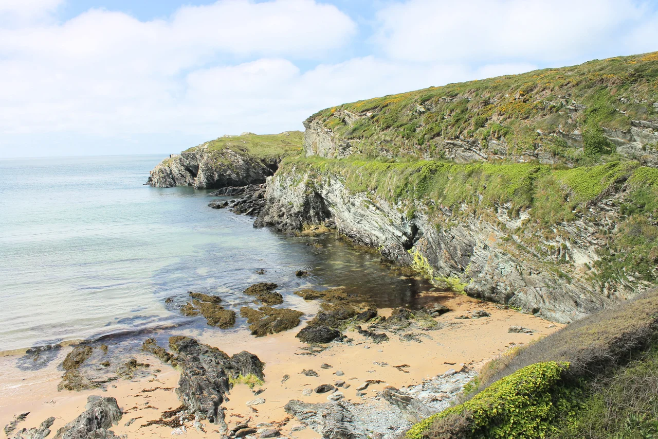

Porth Dafarch
Before the Holyhead Breakwater existed, when north winds made the main port too dangerous to enter, the Dublin packet boats would sometimes divert here instead. Porth Dafarch is a small sheltered bay on the west side of Holy Island - about 100 metres across, walled with Precambrian rock that has been eroded into sea caves and high cliffs, opening southwest into the Irish Sea. There is an old customs post dating from 1819 still standing above the beach, a Grade II listed reminder of the days when this little inlet was a working alternative port. Today it is a Blue Flag beach with a sandy bottom, popular for swimming, rock-pooling, surfing, sea kayaking, and the unusual claim to fame of being the landfall point for a major transatlantic fibre-optic cable.
What the Name Might Mean
The Welsh name is more complicated than it looks. Some sources interpret it as a contraction of Porth Dau Farch, 'Harbour of the Two Stallions'. Welsh placename scholars are fairly sure this is wrong. The actual etymology is uncertain - the name has been recorded in documents as Porth Davagh (1545), Porth y Daferch (1789), Porth y Dafarch (1799), Porth Daverch (1878), and finally Porth Dafarch since 1838. The tentative suggestion is that 'Tafarch' (which softens to 'Dafarch' after the word porth, meaning harbour) was a personal name - someone called Tafarch whose connection to this particular bay has been forgotten entirely. So: probably 'Tafarch's Harbour', after a person no one now remembers. The 'two stallions' story may be a folk etymology invented later to make sense of an unfamiliar word.
The Back-Up Port
From the mid-seventeenth century until the early nineteenth, Porth Dafarch served as the alternative to Holyhead when north winds made the main harbour impossible to enter. Mail and passengers heading for Dublin would be landed here when the prevailing conditions made the regular port unworkable. The customs post built in 1819 - now in poor condition and fenced off from public access, but still a Grade II listed building - dates from the last phase of this back-up role. Within a few years, the calculus changed. Steam packet service began in 1822, less dependent on wind direction. The Holyhead Breakwater started construction in 1848 and was completed in 1873. With a sheltered harbour and steam propulsion, the bad-weather problem that had created Porth Dafarch's secondary harbour role disappeared. The customs post became redundant. The bay reverted to being just a bay.
What Lies Under the Sand
In the winter of 2011 and 2012, between mid-December and mid-January, engineers landed a marine fibre-optic cable at Porth Dafarch. The CeltixConnect cable - 72 fibre pairs running between Ireland and the UK - was laid in about thirty days and makes landfall here, on this small Welsh beach that once served as the backup ferry port. The cable carries an enormous amount of internet traffic between the two countries. Most beachgoers have no idea it is there. Scuba divers visiting the bay are usually more interested in the SS Missouri, a 3,000-ton vessel wrecked on its way to Boston in 1886 and now sitting in shallow water just offshore, a popular wreck dive for divers based out of Holyhead. The Missouri is what you can see; the cable is what you cannot.
What You Do Here Now
In 2021, Porth Dafarch was awarded Blue Flag status - the international beach quality designation - confirming what locals already knew: this is one of the cleanest and safest swimming beaches on Holy Island. The bay is popular for windsurfing, surfing, canoeing, sailing, jet skiing, and the slightly Welsh-specific sport of coasteering, where you traverse the rocky coast on foot, swimming and jumping between sections of cliff. The Anglesey Coastal Path runs along the cliff tops above the bay; campsites are nearby. The 100-metre-wide sandy beach sits at the bottom of cliffs cut from rock older than complex life on Earth - the Precambrian Monian Supergroup, formed before there were trilobites in the seas. The juxtaposition is part of the appeal: stand on a Blue Flag beach, look up at the geological story of the planet, and watch the small ferries and dive boats heading out into the Irish Sea.
From the Air
Porth Dafarch is a small bay on the west coast of Holy Island at 53.29N, 4.65W, about 2 miles southwest of Holyhead and 1.5 miles northwest of Trearddur Bay. From the air it appears as a small sandy crescent set between low rocky headlands, with the Anglesey Coastal Path visible above. Holyhead Mountain rises sharply to the northeast. Nearest airfields: RAF Valley (EGOV) 5nm southeast, Caernarfon (EGCK) 22nm southeast. Best viewed at 1,000-2,000ft AGL in clear conditions. The bay opens southwest into the Irish Sea.
Nearby Stories
- Snowdon Mountain Railway 8 km away
- German submarine U-1051 8.3 km away
- German submarine U-246 11 km away
- Trwyn Du Lighthouse 13 km away
- Irish Sea Bridge 20 km away
- HMS Manners (K568) 34 km away
- HMS Tyler 47 km away
- Birkdale Palace Hotel 79 km away