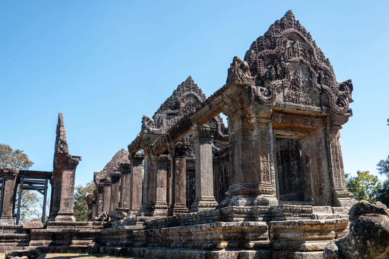

Preah Vihear
The name translates as "vihara of the gods," and standing at the clifftop sanctuary on a clear morning, you understand the presumption. Preah Vihear sits at the edge of the Dângrêk escarpment, 525 meters above the Cambodian plains, looking north toward Thailand across a border that has never quite settled. The Khmer Empire built this temple between the ninth and twelfth centuries, modifying it across the reigns of successive kings, orienting it along a north-south axis rather than the conventional east — an unusual choice that points the main approach toward the plains below and makes the sanctuary feel like it is reaching toward the sky rather than rooted in the earth. It is 140 kilometers from Angkor Wat. It is the subject of two rulings by the International Court of Justice, artillery exchanges in 2011, and another round of conflict in 2025. The temple outlasted all of it.
Built for the Mountain
The architecture of Preah Vihear uses the cliff itself as its primary design element. The complex runs almost a kilometer along the ridge, from the lowest gopura at the northern end to the main sanctuary at the clifftop to the south — a gradual ascent punctuated by five gateway towers, each one blocking the view of the next until you pass through it. The effect is deliberate: you cannot see the temple as a whole from any single point. Each gateway reveals only the next threshold. The fifth gopura, in the Koh Ker style, still carries traces of the red paint that once covered it; the fourth holds what one architectural study calls "one of the masterpieces of Preah Vihear" — a carved pediment depicting the Churning of the Sea of Milk, the Hindu creation myth in stone. The sandstone blocks used for the main tower weigh no less than five tons. The mountain stairway leading up from the modern entrance gate consists of 163 steps, eight meters wide, cut directly into the rock. The difficulty of the climb, the temple's builders believed, symbolized the labor of faith required to approach the sacred world.
The Line on the Map
Preah Vihear sits on the Dângrêk ridge, which forms the natural watershed between Cambodia and Thailand. The watershed would place the temple in Thailand. But a 1907 French colonial map — drawn during the period when France administered Indochina — showed the border line dipping south of the ridge at this point, placing the temple in Cambodia. Thailand used the watershed in its own maps. The discrepancy went unresolved until 1962, when the International Court of Justice in The Hague ruled in favor of Cambodia nine votes to three, relying on the principle that Thailand had accepted the French map's authority through decades of conduct without formal protest. Thailand reacted with mass demonstrations. Rather than lower the Thai flag that had flown at the temple, Thai soldiers dug up the flagpole and moved it to a nearby cliff, where it remained. In January 1963, Cambodia formally took possession of the site in a ceremony attended by around 1,000 people. Prince Sihanouk climbed the cliff himself and announced that Thais would be welcome to visit without visas.
The Temple at War
The high cliff that made Preah Vihear sacred also made it militarily strategic. When Cambodia's civil war began in 1970, Lon Nol government soldiers held the temple long after the plains below fell to communist forces. Even after the Khmer Rouge captured Phnom Penh in April 1975, defenders at Preah Vihear held out for another six weeks before the Khmer Rouge succeeded in shelling and scaling the cliff on May 22, 1975. The defenders stepped across the border and surrendered to Thailand rather than to the Khmer Rouge. The temple changed hands again as the Vietnamese army invaded Cambodia in December 1978 to overthrow the Khmer Rouge. Guerrilla warfare kept the site largely inaccessible through the 1980s; it opened briefly to visitors in 1992, was re-occupied by Khmer Rouge fighters in 1993, and finally saw the last significant Khmer Rouge force surrender there in December 1998. Visitors were admitted again from the Thai side at the end of that year. Cambodia's access road up the cliff from the Cambodian side was completed only in 2003.
The Forty-Two Thousand
On June 12, 1979 — in the chaos following the Vietnamese invasion, with hundreds of thousands of Cambodians fleeing toward Thailand — the Thai government of General Kriangsak Chomanan announced it would expel a large number of Cambodian refugees who had sought safety inside Thailand. Foreign diplomats and aid workers scrambled to the border that night and selected 1,200 people from among thousands held behind barbed wire at Aranyaprathet to be resettled in the United States, France, and Australia. The remaining refugees were loaded onto buses. An American embassy official counted the buses and estimated that approximately 43,000 to 45,000 Cambodians were taken to Preah Vihear. At the top of the escarpment, they were unloaded and forced down the cliff. There was no path. Soldiers threw rocks. People tied their children to their backs and descended using vines. The United Nations High Commissioner for Refugees later estimated that as many as 3,000 people died in the pushback and another 7,000 were unaccounted for. The temple that had witnessed centuries of pilgrimage witnessed this as well.
World Heritage, Contested Ground
In July 2008, UNESCO added Preah Vihear to the World Heritage List, despite Thai protests that the map used in the inscription process implied Cambodian ownership of disputed adjacent land. The listing triggered a new escalation. Military clashes at the border occurred in October 2008, February 2011, and repeatedly thereafter. Artillery exchanges in February 2011 damaged structures at the temple — both sides blamed the other for initiating the fire. A UNESCO mission to assess the damage found evidence of gunfire from both directions. The ICJ issued a provisional ruling ordering both sides to withdraw their forces. In November 2013, a final ICJ ruling confirmed that the land adjacent to the temple on the east and west belongs to Cambodia. In 2025, fresh conflict at the Cambodia-Thailand border again brought damage to the temple. The stone that Khmer craftsmen lifted into place a thousand years ago, weighing no less than five tons per block, has survived invasions, civil wars, forced expulsions, and artillery. It continues to survive.
From the Air
Preah Vihear sits at 14.39°N, 104.68°E on the Dângrêk escarpment at the Cambodia-Thailand border, at an elevation of 525 meters above the Cambodian plains. The escarpment is a dramatic terrain feature visible from considerable altitude — a forested ridge with a steep southern cliff face overlooking flat agricultural land. The temple complex runs along the ridgeline and is identifiable from the air by its north-south axis and the access road ascending the cliff from the Cambodian side. The international border runs along or near the ridge. Nearest airports: Siem Reap International (SAI/REP), approximately 140 km south; on the Thai side, Buriram Airport (BFV) approximately 130 km northwest. Exercise caution regarding the proximity to the Thai-Cambodian border and the active sovereignty dispute in the area. Mountain weather conditions on the Dângrêk escarpment can change rapidly.
Nearby Stories
- Emerald Triangle (Southeast Asia) 10 km away
- Wat Pa Maha Chedi Kaew 19 km away
- Koh Ker 32 km away
- Cambodian Landmine Museum 60 km away
- Si Phan Don 78 km away
- Vat Phou 81 km away
- Angkor Thom 101 km away
- Si Thep Historical Park 328 km away