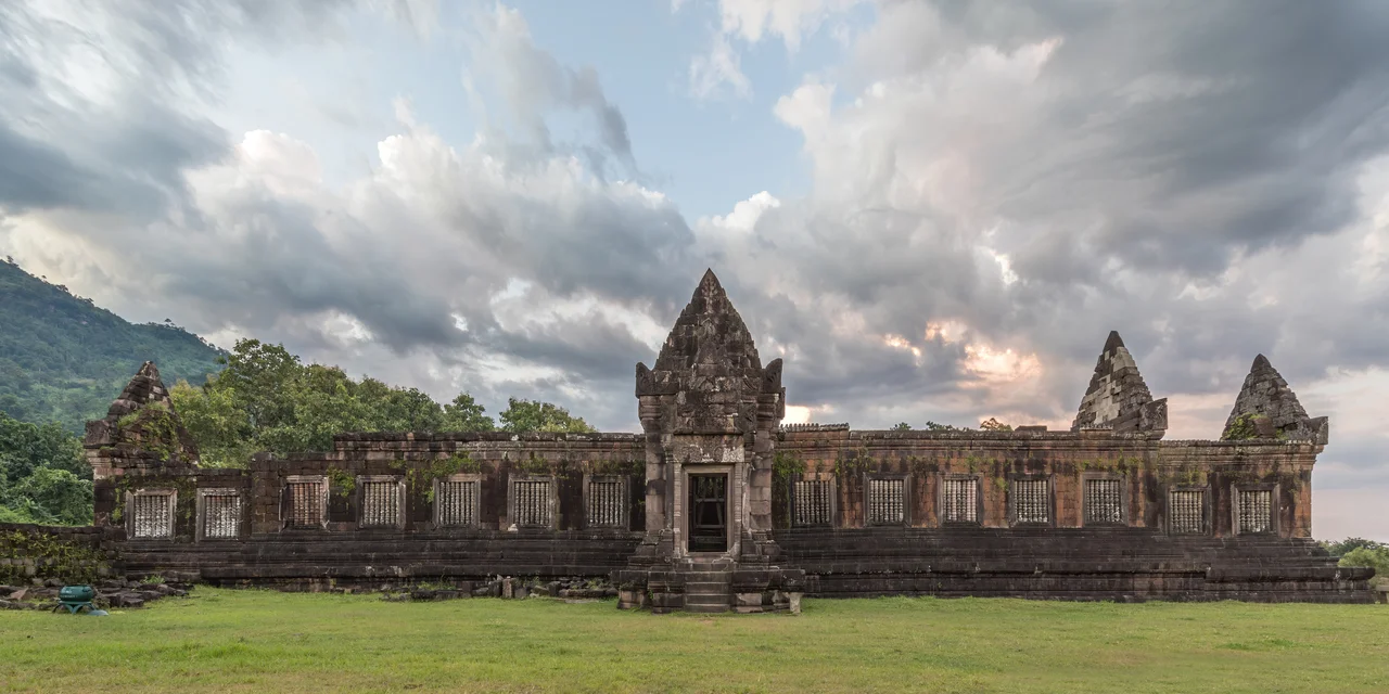

Vat Phou
Before Angkor rose to glory, there was Vat Phou. Long before the Khmer Empire reached the height of its power, priests were already climbing this mountainside in southern Laos, drawn by a summit that nature had carved into the shape of a lingam — the sacred symbol of Shiva. The mountain was not merely a backdrop for worship. It was the god's body. Spring water emerging from the cliffside was channeled along stone aqueducts to continuously bathe the sacred lingam in the inner sanctuary, making the deity perpetually present. This is one of the oldest continuously venerated places in Southeast Asia, and perhaps the most dramatically situated: a stone temple climbing a jungle hillside toward a peak that believers understood as divine.
A Mountain Made Sacred
The first megalithic stone structures at Vat Phou were built probably as early as the second century BCE — two stone cells, serpent stairs, a crocodile carving, and several offering platforms arranged around a sacred spring. The mountain above, Phou Khao, drew its spiritual power from the lingam-shaped protuberance on its summit. People looked up and saw Shiva. The river below — the Mekong, flowing six kilometers to the east — became, in the cosmological imagination, the Ganges or the cosmic ocean encircling Mount Meru.
By the latter part of the fifth century, a city called Shrestapura had grown up on the Mekong's west bank, directly east of the mountain. Inscriptions and texts connect this polity with the Chenla Kingdom and with Champa. One of the first pre-Angkor brick buildings at the site was erected in the early seventh century, anchoring all the construction that followed. The complex had, centuries before the word existed, a masterplan — and that plan was determined by geography, not architects.
The Khmer Empire Builds in Stone
By the reign of Yasovarman I in the early tenth century, Vat Phou had been absorbed into the expanding Khmer Empire centered on Angkor. The Angkorian period brought a new city south of the temple and, eventually, new stone construction. The temple visible today was built primarily during the Koh Ker and Baphuon periods of the eleventh century, re-using stones from earlier structures in a layering of history that continues throughout the site.
The layout stretches 1.4 kilometers east from the spring at the cliff's base. Approached from what was once the city, visitors first encountered a series of barays — great rectangular reservoirs. Only one still holds water, the 600 by 200 meter middle baray aligned precisely along the temple's axis. Beyond the reservoirs, two stone palaces face each other across the central causeway, notable for their Angkor Wat-style pediments and lintels. Successive terraces and staircases then climb the hill, past a shrine to Nandi, past the remains of six smaller shrines destroyed by treasure hunters, to the upper sanctuary carved from sandstone seven tiers high.
What the Sanctuary Holds
The central sanctuary is in two parts. The front section, built of sandstone, now shelters four Buddha images — placed here after the temple was converted to Theravada Buddhist use during the empire's final centuries. The brick rear chamber, which once housed the central lingam, is empty. The roof is gone entirely, though a makeshift covering has been added at the front. The loss is partly offset by what remains: the three doorways on the east face carry pediments showing Krishna defeating the naga Kaliya; Indra riding Airavata, the divine elephant; and Vishnu riding Garuda. A lintel on the south entrance shows Krishna ripping the tyrant Kamsa apart — an image of cosmic justice carved with startling confidence into stone a thousand years ago.
Elsewhere on the hillside, boulders have been shaped to resemble elephants and a crocodile. The crocodile stone has drawn particular attention: a sixth-century Chinese text describes an annual human sacrifice at a site matching its dimensions, and the crocodile is large enough to accommodate a human body. The identification is unproven. The stone simply waits, worn and ambiguous, at the edge of the jungle.
Two Thousand Years of Continuity
What makes Vat Phou exceptional — what earned it UNESCO World Heritage designation in 2001 — is that it shows Khmer stone architecture from its earliest megalithic beginnings through the mature Angkorian style of the thirteenth century. No other site compresses that full developmental arc into a single hillside. Unlike Angkor, which was abandoned after the Khmer withdrawal, Vat Phou never stopped being used. The Lao people who came to control the region after the empire's decline continued the festivals, continued the offerings, and every February still hold a major celebration at the site. Conservation projects by France, Italy, India, and UNESCO have worked to stabilize the palaces and document what remains, but much of the complex still stands as the jungle left it — walls tilted, lintels cracked, moss finding every seam in the stone.
The museum at the site collects centuries of artifacts: Shiva, Vishnu, Nandin, and Buddhist statues recovered from the complex, a compressed survey of every religion that has climbed this hill.
From the Air
Vat Phou sits at approximately 14.85°N, 105.82°E, at the base of Phou Khao mountain in Champasak province, southern Laos. From the air, the site is identifiable by its staircase of terraces climbing from the flatlands toward the forested summit — the mountain's profile, with its distinctive peak, serves as a reliable landmark. The Mekong River is visible six kilometers to the east. Recommended viewing altitude is 2,000–3,500 feet for detail of the temple layout and surrounding rice paddies. The nearest airport with regular service is Pakse International Airport (PKZ), approximately 40 km to the north. The dry season (November through March) offers the clearest views; haze builds through March and April.
Nearby Stories
- Paksong 9.9 km away
- Lao Airlines Flight 301 10 km away
- Phu Chong–Na Yoi National Park 29 km away
- Ubon Ratchathani 30 km away
- Bolaven Plateau 41 km away
- Khao Phra Wihan National Park 44 km away
- Wat Nong Pah Pong 46 km away
- Veun Sai-Siem Pang National Park 88 km away