Puncak Jaya
In 1623, a Dutch sea captain named Jan Carstenszoon told Europe he had seen snow on the equator. They laughed at him. For more than two centuries his name became shorthand for the kind of traveler's tale that belonged alongside mermaids and sea serpents. Puncak Jaya, which Carstensz had sighted on a rare clear day from the Arafura Sea, rises 4,884 meters from the Sudirman Range on the island of New Guinea. It is the highest point of any island on Earth. It is the highest peak in Indonesia. It is the highest summit between the Himalaya and the Andes. And, yes, near the equator, it still carries ice.
Peak of the White Arrow
To the Amungme people whose ancestral lands cradle the mountain, the summit is Nemangkawi Ninggok, Peak of the White Arrow. In the Indonesian renaming of 1963, it became Puntjak Soekarno, after the first president. When Sukarno fell, so did his name on the map; the peak was renamed Puncak Jaya, Glorious Peak, which is what it still shows on official charts. Mountaineers from elsewhere tend to use Carstensz Pyramid, the name that stuck from the explorer who first sighted the ice. One mountain, four names, each the residue of a different era of who thought they owned this piece of sky.
The Hardest of the Seven Summits
Puncak Jaya is on most lists of the Seven Summits, the tallest peak on each continent, and it is widely considered the technically hardest of the seven despite being the lowest. The summit ridge is limestone, sheer, and the rock demands real climbing rather than the slogging endurance that gets people up Denali or Aconcagua. The mountain also demands something before any of that: access. It was closed to climbers between 1995 and 2005. Reaching base camp requires a flight into Timika, then a small aircraft onto an unimproved runway at a highland village, then roughly five days of hiking through dense rainforest under near-constant rain. Some descriptions call it the most miserable approach on any Seven Summits attempt. Helicopter rescue is not reliably available. If you get hurt on the walk in, you walk out.
The First Ascents
The 1936 Dutch Carstensz Expedition, led by Anton Colijn with Jean Jacques Dozy and Frits Wissel, aimed at all three summits. On 5 December they reached the ice-covered East Carstensz and Ngga Pulu. Weather defeated them on the bare Carstensz Pyramid. At that time, Ngga Pulu was the highest; the Pyramid appeared as a subsidiary spire. The Pyramid itself did not see a successful first ascent until 1962, when a party led by Austrian mountaineer Heinrich Harrer, New Zealand climber Philip Temple, Australian Russell Kippax, and Dutch officer Albertus Huizenga finally stood on the true summit. The climb, remarkably, had waited until Sir Edmund Hillary had already come off Everest.
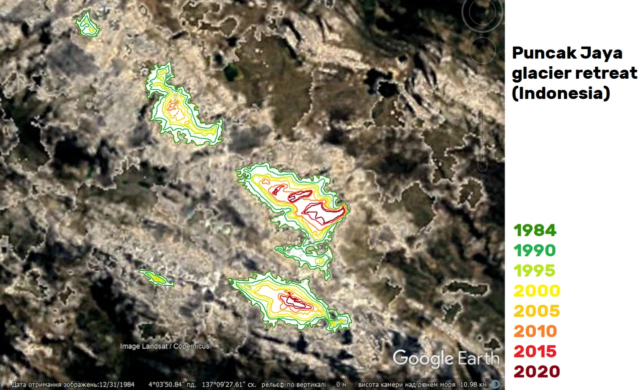
The Vanishing Ice
Puncak Jaya's summit itself is bare rock, but several glaciers hang on its flanks: the Carstensz Glacier, the East and West Northwall Firns, and, until recently, the Meren Glacier in the Meren Valley. Meren is Dutch for lakes. The glacier for which the valley is named melted out of existence sometime between 1994 and 2000. Satellite imagery since the 1970s shows continuous retreat. Researchers estimate that every glacier remaining on New Guinea may disappear by 2030. These are among the last equatorial glaciers on Earth, and they are ending within the lifetimes of the people watching them end. The peak itself, lifted from Miocene limestone by the oblique collision of the Australian and Pacific plates, will outlast them by millions of years. The ice is going quickly.
The Cost in Lives
The mountain has taken climbers with a regularity that reflects how unforgiving the combination of altitude, rain, technical rock, and remote access becomes when something goes wrong. Erik Airlangga died of hypothermia in 2016 after getting caught in extreme weather. Ahmad Hadi died of hypoxemia in 2017. In the 2024 season two more climbers were lost: one to a suspected heart attack on 29 September, and Chinese mountaineer Dong Fei in a fall during descent. In March 2025, Lilie Wijayati Poegiono and Elsa Laksono died of hypothermia descending after being trapped in extreme weather. Four kilometers west of the summit, the open-cut Grasberg gold and copper mine grinds on, one of the largest gold operations in the world. The mountain holds both things at once: equatorial snowfields dissolving into cloud, and an industrial pit visible from orbit.
From the Air
Located at 4.08°S, 137.18°E in the Sudirman Range, Central Papua. Elevation 4,884 m makes this the highest point on any island on Earth. Maintain well above 17,000 ft for terrain clearance. The Grasberg mine pit, 4 km west of the summit, is a distinctive visual reference visible from high altitude. Nearest major airport is Mozes Kilangin Timika (ICAO: WABP), about 100 km south at sea level. Expect severe afternoon weather; early-morning windows offer the best views of the ice cap and limestone ridgeline.
Nearby Stories
- Lorentz National Park 40 km away
- Mapenduma Hostage Crisis 44 km away
- Republic of West Papua 69 km away
- Western New Guinea 104 km away
- Central Papua 145 km away
- Foja Mountains 199 km away
- 2026 Smart Air Cessna 208 Crash 217 km away
- The Abyss That Isn't a Trench 647 km away