.jpg)
The Rim Fire
Thirty-five minutes. That is how long it took the Rim Fire to grow from 40 acres to 150, already throwing spot fires ahead of its main flame front into the dry August air above the Clavey River canyon. By the time the first air tanker arrived at 3:47 p.m. on August 17, 2013, incident commanders already knew the math was working against them. The terrain was too steep for ground crews to engage directly. The vegetation -- pine plantations replanted after 1987 fires, never thinned, uniform in size -- was a loaded gun. And California had entered the summer on below-normal precipitation, leaving fuels parched to dangerous levels. What started as a hunter's illegal campfire in a remote canyon of the Stanislaus National Forest would burn for nine weeks, consume 257,314 acres, and become the largest wildfire in the history of Yosemite National Park.
A Landscape Primed to Burn
The Rim Fire did not arrive from nowhere. Decades of wildfire suppression had allowed combustible vegetation to accumulate across the Stanislaus National Forest. After large fires swept through in 1987, the Forest Service replanted thousands of acres with pine plantations -- dense, same-age stands that lacked the structural diversity of natural forest. These uniform blocks of fuel waited for the right conditions. The winter and spring of 2012-2013 brought below-normal rain, and by August, drought gripped the region. Vegetation moisture dropped to critically low levels. The fire took its name from the Rim of the World vista point on Highway 120, a scenic overlook on the road to Yosemite. That name would soon carry a different kind of weight.
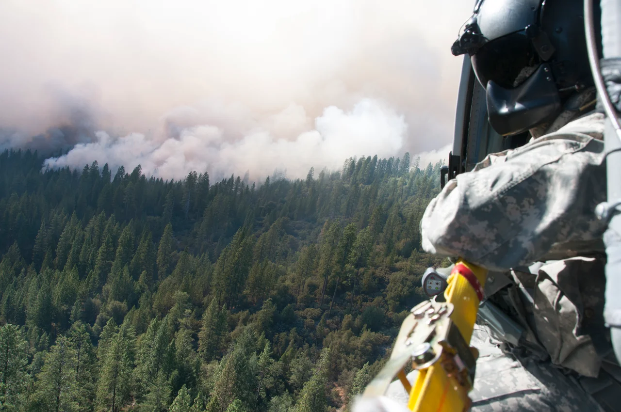
Ninety Thousand Acres in Two Days
The fire's growth was staggering. Within 36 hours, it had consumed 10,000 acres. After four days, 100,000. During a two-day stretch in mid-August, nearly 90,000 acres burned -- an area larger than many national parks. Erratic winds and inaccessible terrain forced firefighters into a reactive posture, chasing a fire that outpaced their best efforts. More than 5,000 firefighters worked the blaze, including more than 650 incarcerated individuals who volunteered through California's Conservation Camp initiative. An MQ-1 Predator drone flew over the fire on August 28 after emergency approvals, providing infrared imagery of hidden hotspots beneath the canopy. State officials took the unusual step of asking residents to avoid social media after exaggerated claims and conspiracy theories began spreading faster than verified information. The fire burned 78,895 acres inside Yosemite National Park, though Yosemite Valley itself was never directly threatened.
San Francisco's Water on the Line
The Rim Fire's reach extended far beyond the Sierra foothills. As flames advanced toward the Hetch Hetchy reservoir, San Francisco confronted the possibility that its primary water source -- supplying up to 85 percent of the city's water to 2.6 million customers -- could be compromised. By August 26, the fire had crept within a mile of the reservoir, and ash was falling into the water. The San Francisco Public Utilities Commission moved water into downstream reservoirs in San Mateo and Alameda Counties as a precaution. The fire also knocked two of three hydroelectric plants offline, damaging power infrastructure that served the Bay Area. Smoke drifted as far as Reno and Lake Tahoe, forcing cancellation of outdoor events and sending schoolchildren home. From the San Joaquin Valley to the high Sierra, air quality readings spiked to unhealthy levels repeatedly during the fire's most active weeks.
Fifteen Thousand Under Evacuation
On the ground, the human toll accumulated in disruption and fear. At the height of the danger, an estimated 15,000 residents were under evacuation order or advisory. Law enforcement command posts went up in Groveland and Tuolumne City, and the mutual aid response became the largest in the history of California's Law Enforcement Mutual Aid System. Communities including Pine Mountain Lake, Big Oak Flat, Tuolumne Rancheria, and Miwuk Village were prepared for evacuation. The fire destroyed 112 structures, mostly outbuildings. Ten injuries were reported; remarkably, there were no fatalities. Berkeley Tuolumne Camp, a family camp operating since 1922, burned to the ground. The suppression effort cost more than $127 million, with FEMA eventually agreeing to reimburse California for up to 75 percent of eligible costs.
What the Owls Found
The fire was contained on September 6, 2013, though logs smoldered through the winter and the blaze was not declared fully extinguished until November 2014. What happened next surprised researchers. California spotted owls at 45 breeding sites within the fire perimeter recorded their highest-ever occupancy rates one year after the burn. Sites that had experienced 100 percent high-severity fire hosted nesting pairs at the same rate as unburned forest. Great gray owl surveys told a similar story: no significant difference in owl detection between burned and unburned areas. The forest, it turned out, knew something about fire that decades of suppression policy had tried to deny. The recovery debate was contentious -- the final salvage logging plan reduced from 660 million board feet to 210 million, leaving snag habitats for Black-backed Woodpeckers while attempting to balance economic value and ecological recovery. The man charged with starting the fire, Keith Matthew Emerald of Columbia, California, saw his charges dropped in 2015 when two key witnesses died. The Rim Fire slipped from California's third-largest recorded wildfire to its twelfth as subsequent fire seasons rewrote the record books. But in the Stanislaus, the scars remain -- and so does the forest, finding its way back.
From the Air
Located at 37.85°N, 120.08°W in the Stanislaus National Forest, Tuolumne County. The Rim Fire burn scar is visible from altitude as a large area of altered forest cover between Highway 120 and the Clavey River drainage, extending east into Yosemite National Park. The Hetch Hetchy reservoir is visible to the east. Pine Mountain Lake airport (Q68/E45) lies to the west near Groveland. Columbia Airport (O22) is approximately 20 miles south. Modesto City-County Airport (MOD) is about 60 miles west. The burn scar covers roughly 400 square miles of mountainous terrain.
Nearby Stories
- Lake Tulloch: From Miner's Ditch to Foothill Reservoir 1.7 km away
- The Bullet That Burned 34,000 Acres 7.8 km away
- Yamato Colony: The Forty-Acre Bet 26 km away
- Indian Grinding Rock State Historic Park 32 km away
- Bodie Ghost Town 46 km away
- Mono Lake 48 km away
- Gold Country 71 km away
- The Bristlecone Pines: The Oldest Living Things on Earth 122 km away