The Bullet That Burned 34,000 Acres
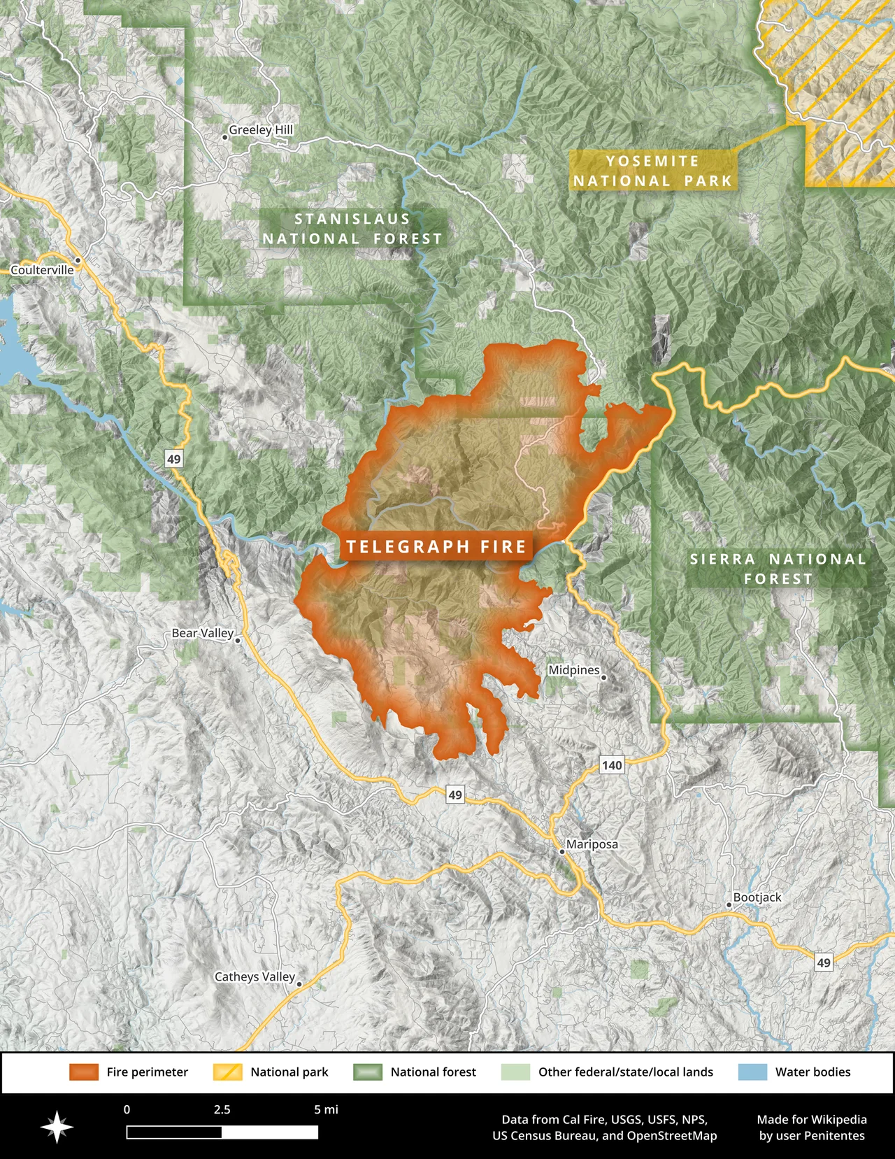
It started with a bullet. On July 25, 2008, near the junction of Sherlock Road and Telegraph Road in Mariposa County, a target shooter fired a .30-caliber rifle loaded with steel-jacketed ammunition -- the kind banned in some areas precisely because of what happened next. The bullet struck a rock, threw sparks into the dry brush, and the three people present tried to douse the flames with water. They failed. Within days, their afternoon of shooting practice had become the Telegraph Fire, a 34,091-acre inferno tearing through the Sierra Nevada foothills west of Yosemite National Park, destroying homes, choking the park with smoke, and costing $37.6 million to extinguish.
A Century of Fuel
What made the Telegraph Fire so ferocious was not the spark itself but what lay waiting for it. The burn area had experienced no recorded wildfire in roughly a hundred years. A century of unburned vegetation had accumulated in the foothills -- dense chaparral, dry grasses, deadfall timber -- all of it baking under a California summer that had already ignited thousands of other fires across the state. The 2008 wildfire season would ultimately consume 1,593,690 acres statewide, more than double the five-year average. The terrain compounded the problem. Steep, inaccessible ravines and ridgelines made it nearly impossible for ground crews to establish firebreaks, forcing much of the suppression effort into aerial operations. By the night of July 28, just three days after ignition, the fire had already consumed 27,000 acres and stood at only ten percent containment.
Yosemite Under Smoke
The Telegraph Fire never crossed into Yosemite National Park, but the park felt it. Smoke poured into Yosemite Valley, degrading air quality and visibility for the millions of visitors who come each summer to see the granite walls and waterfalls. The National Park Service kept Yosemite fully open throughout the crisis, but the haze turned iconic views into gray approximations of themselves. Tourism suffered across the region. The fire cut power to parts of the area, and the threat to 2,000 homes in surrounding communities forced mandatory evacuations. Residents packed what they could carry and watched the ridgelines for the orange glow that would mean their homes were next. The emotional toll was considerable -- families uncertain for days whether they still had a house to return to, the acrid smell of burning pine a constant companion even miles from the fire's edge.
The Fight to Contain
At its peak, the suppression effort deployed hundreds of firefighters across some of the most difficult terrain in the Sierra foothills. The inaccessible canyons that had allowed fuel to accumulate for a century now made every tactical decision harder. Crews worked through extreme heat and steep grades, and at least 22 firefighters sustained injuries -- all minor, a point of professional pride given the conditions. On August 1, the Mariposa County Board of Supervisors declared a state of emergency to unlock federal aid, an acknowledgment that local resources had been overwhelmed days earlier. Containment crept upward: from ten percent on July 28 to sixty percent by late July, then steadily higher as crews carved firebreaks through the brush. The fire was declared fully contained on August 6, twelve days after that first spark.
What It Cost
The price tag was staggering. Fire suppression alone cost $37.6 million in 2008 dollars. Property damage added millions more -- at least 21 homes destroyed, with some reports counting as many as 30, along with dozens of outbuildings, barns, and sheds. Remarkably, no one died. All evacuated residents were allowed to return by August 1, though many came back to find their properties reduced to foundations and ash. The landscape itself bore scars that would take decades to heal. Dense stands of chaparral and oak woodland, untouched by fire for a century, were replaced by blackened hillsides that would be vulnerable to erosion and mudslides for years to come.
A Spark That Echoes
California ultimately declined to press criminal charges against the shooter, though he was sentenced in December 2008 on related offenses. The Telegraph Fire became a cautionary example in fire-safety education -- a reminder that steel-jacketed ammunition and dry hillsides are a combination that can cost tens of millions of dollars and dozens of homes. It also underscored a truth that fire ecologists had been warning about for decades: the longer a landscape goes without burning, the more catastrophic the eventual fire will be. The foothills west of Yosemite had avoided fire for a hundred years, and when it finally came, a century of accumulated fuel ensured it would burn with extraordinary intensity. That pattern -- suppression breeding future catastrophe -- would repeat across California in the years that followed, each fire season seeming to outdo the last.
From the Air
Located at 37.57N, 120.00W in the Sierra Nevada foothills of Mariposa County, approximately 30 miles west of Yosemite Valley. The burn scar is visible from altitude as a lighter-toned patch amid darker surrounding forest. The terrain is rugged with steep ravines and ridgelines typical of the Sierra foothill zone. Mariposa-Yosemite Airport (KMPI) lies roughly 10 miles to the southwest. The fire burned along the corridor between Sherlock Road and Telegraph Road, with Highway 140 -- the primary route into Yosemite from the west -- running through the affected area.
Nearby Stories
- The Rim Fire 6.7 km away
- The Covered Bridge That Outlasted Everything 7.5 km away
- The Lake They Almost Nuked 8.6 km away
- Merced National Wildlife Refuge 11 km away
- Yamato Colony: The Forty-Acre Bet 17 km away
- Mono Lake: Where Salt Towers Rise From Dying Water 52 km away
- Mono Lake 71 km away
- Sequoia: Standing Among the Largest Living Things on Earth 122 km away