
Ruisui
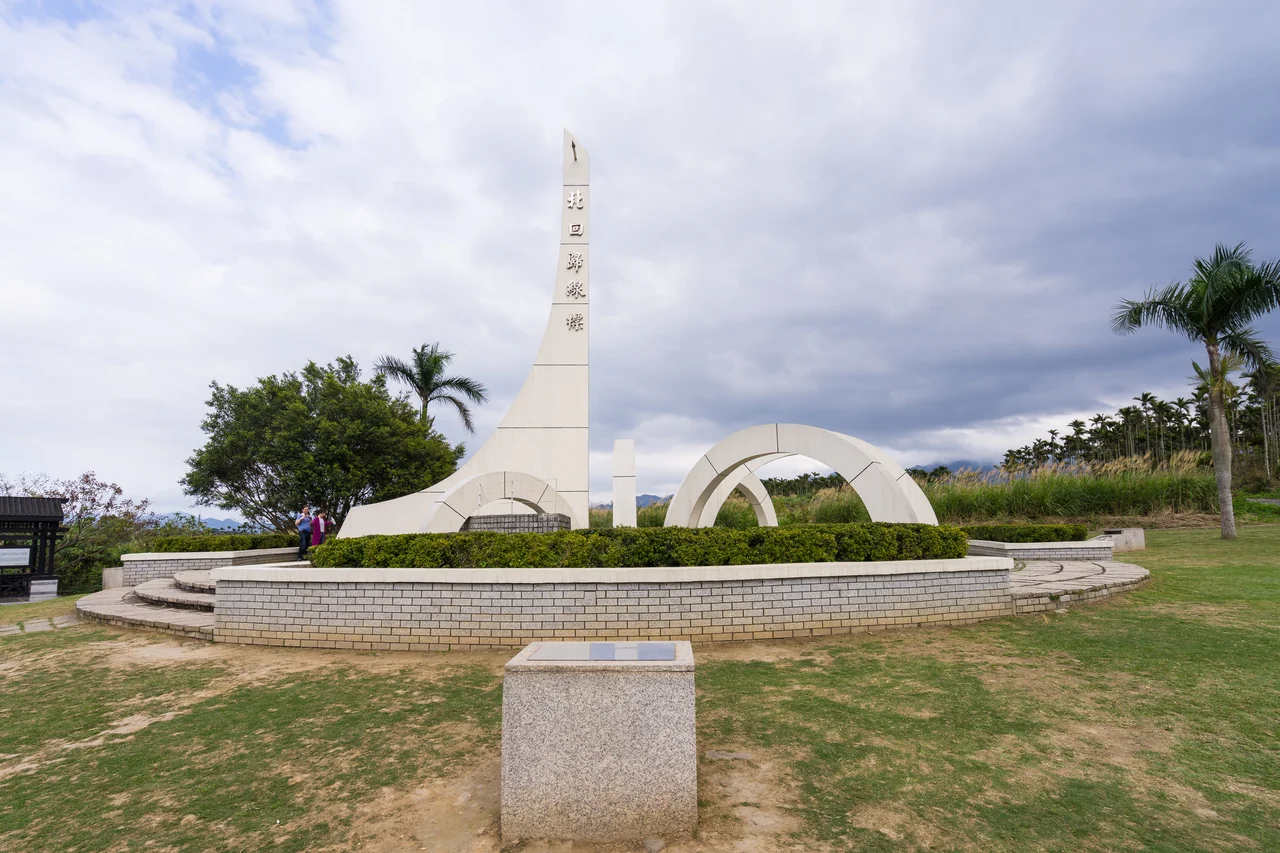
Twice a year the sun aligns with the Tropic of Cancer, and at solar noon on the summer solstice, the white sundial-shaped monument in Ruisui Township casts no shadow at all. The marker stands near Highway 9 at roughly kilometer 275.5, on the Wuhe Terrace above the Xiuguluan River. The original structure was built in 1933; the current one was relocated in 1981, its four mythological animal statues standing guard around the gnomon. For one moment each June 22nd, this ordinary stretch of eastern Taiwan's Rift Valley sits exactly on the line dividing the tropics from the subtropics—a geographical fact turned into a monument, turned into a landmark, turned into the kind of thing you stop and photograph even if you understand why it only means something for thirty seconds a year.
The Golden Spring
Japanese colonists called it the 'golden spring,' and the name makes sense as soon as you see the water. Ruisui's hot springs emerge at around 48°C, weakly alkaline and rich in sodium bicarbonate, carbonate, iron, and barium. The iron is the detail that matters for the color: when the water hits open air, it oxidizes to a faint gold. The first public bathhouse opened here in 1919 under the Japanese colonial administration, which recognized the springs' therapeutic properties and built infrastructure accordingly. The springs are sometimes described locally as the only carbonate springs in Taiwan—a claim that speaks to their distinctive mineral character even if the superlative is hard to verify. The bathing temperature range of 43–48°C is warm enough to be immediately felt at elevation. After a day on the river, the hot spring pools of Ruisui are exactly the right destination.
Twenty-Four Kilometers of River
The Xiuguluan River is eastern Taiwan's largest river, running 104 kilometers in total before reaching the Pacific. The 24-kilometer rafting route from Ruisui Bridge to Changhong Bridge is the section that draws visitors from across Taiwan. More than twenty rapids punctuate the run, which takes three to four hours to complete by rubber raft. The river cuts through a valley flanked by jungle-covered slopes, and the clear mountain water comes directly from the Central Mountain Range above. The rafting season runs roughly spring through autumn; typhoon closures are common in summer, and the river can run very fast after heavy rain. The Amis people have fished and lived along the Xiuguluan for generations, and their name for this stretch of the valley—Kohkoh—predates the Chinese and Japanese administrative names. Wuhe Terrace, the plateau above the river near the Tropic of Cancer marker, is also known for its tea and coffee plantations, the volcanic soil and altitude producing crops unusual for this part of Taiwan's coast.
The Ilisin and the Amis Calendar
Ruisui's population is a mix of Hoklo, Hakka, and Taiwanese indigenous people, the majority of the latter being Amis (also called Pangcah). The Amis are the largest indigenous group in Taiwan, and Ruisui is one of their strongholds on the east coast. Their annual Harvest Festival—the Ilisin—falls in July or August and follows a four-day structure that has remained largely intact for generations: a preparation day, a men-only day welcoming the ancestral spirits, a communal feasting day, and a women-only closing day that formally dismisses the spirits. The Hualien County government designated the Ruisui Ilisin a county folk custom in 2011 and elevated it to county cultural heritage in 2014. The festival is a community event, not a performance staged for visitors, though guests who attend with appropriate respect are generally welcome. The singing, the traditional dress, and the formality of the ritual structure give the Ilisin a weight that more tourist-oriented cultural events rarely achieve.
Ruisui Ranch and the Wuhe Plateau
The Wuhe Terrace sits above the river valley at an elevation that moderates the subtropical heat, and the land there has been used for farming since long before the current generation of agricultural enterprises arrived. Ruisui Ranch—locally known as Rareseed Pasture—has operated since 1969 with a herd of Holstein Friesian cattle now numbering around 300. The ranch produces fresh milk, milk tea, ice cream, cheese, nougat, and various dairy products that have become part of the regional identity; Ruisui milk is a recognizable brand in eastern Taiwan. The combination of the cattle pastures, the tea and coffee plantations, and the distant Pacific visible on clear days from the plateau's eastern edge gives Wuhe Terrace a landscape quality distinct from both the river gorges to the north and the sugar cane lowlands to the south. It is the kind of working agricultural landscape that sustains a community over generations, visible and unhurried.
From the Air
Ruisui Township sits at 23.533°N, 121.406°E in the Hualien County section of the East Rift Valley, Taiwan. From altitude, the Xiuguluan River is visible cutting eastward through its valley toward the Pacific coastal plain. The Wuhe Terrace plateau is the elevated ground north and east of the main township area. The Central Mountain Range rises sharply to the west. Hualien Airport (HUN) lies approximately 57 km north at Xincheng Township and handles domestic routes including services to Taipei Songshan. Taitung Airport (TTT / RCFN) is approximately 65 km to the south.
Nearby Stories
- Lulin Observatory 6.6 km away
- Sanxiantai 10 km away
- Ci En Pagoda 13 km away
- 2024 Hualien Earthquake 14 km away
- Baolai Spring Park 26 km away
- Twin Forts of Romblon 1182 km away
- Sinking of MV Sewol 1228 km away
- Sibuyan Island 1230 km away