
Sanxiantai
A 1755 map labels it simply "Sansana." By that time, the islet off Taiwan's east coast had been known to people navigating this stretch of the Pacific for longer than any surviving document records. In the Amis language it is *nuwalian*. In Mandarin it became Sanxiantai — Platform of the Three Immortals — after the three colossal rocks that punctuate the island's surface. Whatever you call it, the place is unmistakable from the moment the eight-arched footbridge comes into view.
The Bridge That Defines the Place
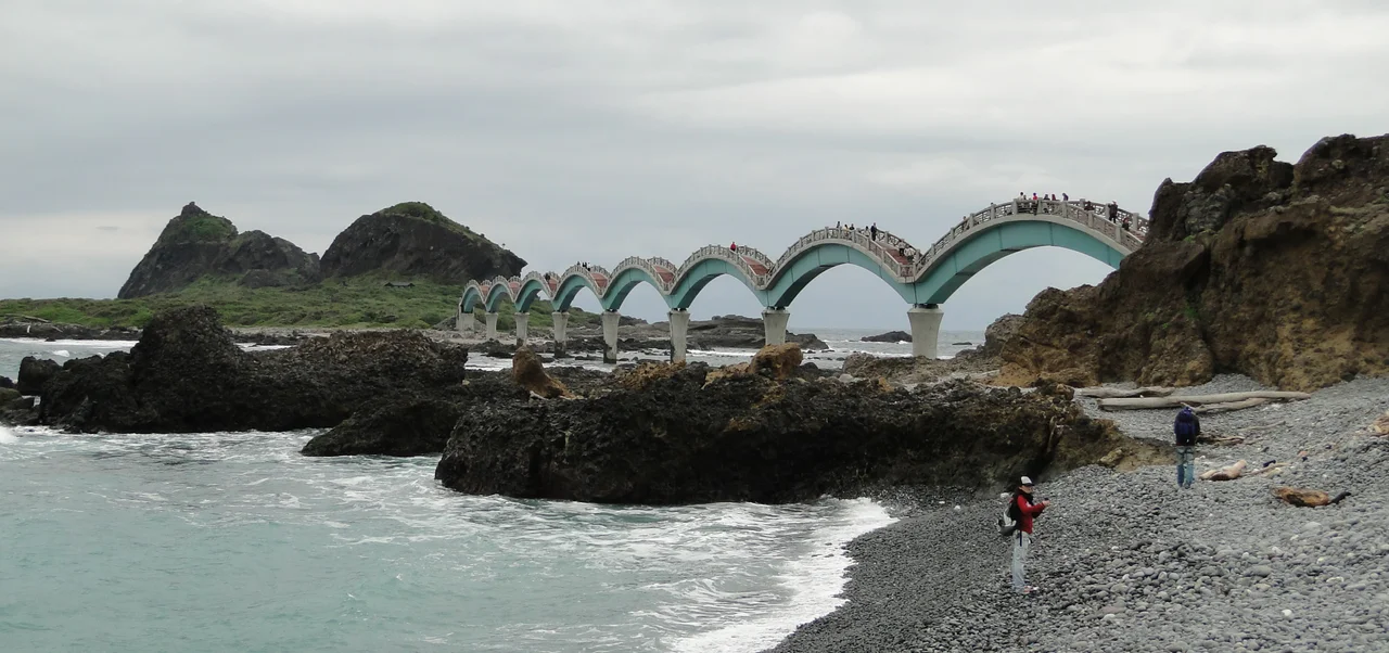
The footbridge connecting the Taiwan mainland coast to Sanxiantai Island is the feature that appears on every photograph of this coastline. Completed in 1987, it stretches nearly 400 meters across the water in eight distinct arches, the whole structure designed to evoke a reclining sea dragon — painted in red and gray, curving with deliberate drama over the reef-studded shallows. Eight arches is not the most efficient way to bridge a gap this size, but efficiency was not the point. The designers understood that this bridge would become the image of the place, and they made it worth the photograph. Walking across it, you move through a series of ascending and descending curves, the Pacific visible on both sides, the three great rocks of Sanxiantai growing in front of you with each arch. The bridge has become so closely identified with the area that to see it is to know immediately where you are.
Three Rocks and a Name
Sanxiantai Island carries three extremely large rocks — boulders of a scale that registers as geological rather than ordinary — that give the place its name and its character. "Sanxiantai" translates as Platform of the Three Immortals, a name that reflects how people made sense of the island's surreal topography: formations this improbable must have a mythological explanation. The island's shape is genuinely unusual, the kind of rocky coastal landform that the Pacific produces when wave erosion works on hard rock over geological time. The beach that extends along the mainland shore stretches ten kilometers in total, providing a long, level approach to the footbridge's southern end. The area sits at the 112-kilometer mark of Provincial Highway 11, the coastal road, which makes it findable even without the bridge as a visual beacon.
Rocky Coasts and Long Memory
The coastline around Sanxiantai is part of the East Coast National Scenic Area, the administrative framework that protects and presents Taiwan's Pacific-facing shoreline. Rocky coastal views are the signature feature — basalt outcroppings, tide pools, wave-carved platforms — giving the area a drama that sandy beaches cannot match. The islet appears on maps dating to the mid-eighteenth century, which means it was a known navigational reference for vessels working the east coast of Formosa at a time when this coast was considered remote even by the standards of the Qing dynasty. The name Sansana, as written on that 1755 map, connects the contemporary tourist destination to a much longer history of human attention to this particular stretch of rock and water. Sanxiantai has been someone's landmark for a very long time.
Where the Pacific Arrives
The islet sits where the open Pacific meets the hard eastern face of Taiwan, which means it gets the full force of what the ocean delivers — waves, wind, and weather unmediated by any offshore protection. The surrounding water is clear and deep-blue in the Kuroshio Current's influence zone, with the kind of visibility that rewards anyone willing to wade or snorkel in the calmer coves. Sunrise at Sanxiantai is a recognized event, significant enough that the Taiwan Tourism Bureau has specifically promoted winter sunrise viewing at the site. When the sun clears the horizon over open water to the east, there is nothing between this coast and the next landmass to the east for thousands of kilometers. The light arrives unobstructed, and the three immortal rocks catch it first.
From the Air
Sanxiantai sits at approximately 23.125°N, 121.417°E, directly on the Pacific coast of Chenggong Township. At 2,000–4,000 feet, the islet and its eight-arched footbridge are clearly visible — the bridge's curved silhouette is a distinctive landmark that aerial observers can use to orient along this coastline. The three large rocks on the island cast visible shadows in angled morning light. The mainland beach extending ten kilometers to the south is a clear linear feature. Nearest airport is Taitung Airport (RCFN), approximately 32 kilometers to the southwest. The deep blue of the Kuroshio Current is often visible offshore — a vivid contrast to the reef-influenced shallows surrounding the islet itself. Best aerial viewing in the dry season (October–April).
Nearby Stories
- Baxian Caves 2.3 km away
- Lulin Observatory 12 km away
- Lüdao Lighthouse 20 km away
- Baolai Spring Park 24 km away
- Kucapungane 26 km away
- Twin Forts of Romblon 1143 km away
- Sibuyan Island 1191 km away
- Sinking of MV Sewol 1265 km away