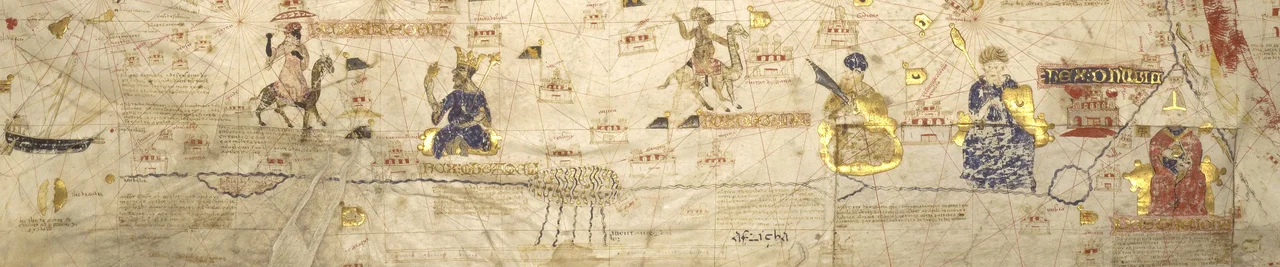
_in_1413_Mecia_de_Viladestes_map.jpg)
Senegal River
For a thousand years, Europe knew this river only as a rumor. On medieval maps it had no proper name, just a label: the River of Gold. Cartographers drew it parallel to the African coast, populated its banks with seated emperors holding nuggets, and sketched giant ants guarding golden sands along its shores. The reality, when sailors finally reached it, was a river 1,086 kilometers long, born in the green highlands of Guinea and running west and north through some of the harshest land in West Africa before pouring into the Atlantic. The gold was real too. The Senegal reached straight into the heart of the empires that mined it.
From Two Rivers to the Sea
The Senegal begins as two rivers. The Bafing and the Bakoy both rise in Guinea and run down to meet at Bafoulabé in Mali, where they merge and take a single name. From there the river flows west, then north, squeezing through the Talari Gorges and crashing over the Gouina Falls before easing past the town of Kayes. It gathers tributaries as it goes, the Karakoro, the Falémé, the Gorgol, and for much of its later course it draws the border between Senegal and Mauritania. Near its mouth it splits and rejoins, wrapping around the long island that holds the old city of Saint-Louis, then runs behind a thin ribbon of sand called the Langue de Barbarie before finally reaching the ocean.
The River of Gold
Around 800 CE, trans-Saharan caravans linked Morocco to the Ghana Empire, and the Senegal became a corridor between the Mediterranean world and the goldfields of the interior. The river ran into the heart of Ghana and, later, the immense Mali Empire, and the traders who carried its gold north gave it its enduring nickname. Arab geographers, al-Masudi in Baghdad, al-Bakri in Spain, al-Idrisi in Sicily, wrote the earliest descriptions, though they believed the Senegal and the Niger were a single "Western Nile" flowing across the whole continent. The error was understandable: the headwaters of the two rivers do come close together in Mali and Guinea. The truth would take centuries, and many lost ships, to untangle.
Mapping a Legend
Drawing on Arab sources and classical legend, European mapmakers put the River of Gold on their charts in the 1300s. The 1375 Catalan Atlas placed Mansa Musa of Mali on its banks, enthroned and crowned, holding a golden nugget, with an inscription naming him the greatest lord of those parts. Midway down the river, charts marked an "Island of Gold," most likely the Bambuk-Buré goldfields, a district nearly ringed by rivers. The lure was irresistible. Genoese, Majorcan, and Norman sailors set out one after another to find the river's mouth and were never heard from again. Cape Bojador, on the route south, became known as the cape of no return, a reputation possibly encouraged by Saharan traders who had no wish to see their land route replaced by sea.
Reaching the Mouth
It was Portugal, under Prince Henry the Navigator, that finally broke through. In 1434 his captain Gil Eanes rounded the dreaded Cape Bojador and returned alive. A decade later, around 1445, a Portuguese ship reached the mouth of the Senegal for the first time since antiquity, where sailors noticed the desert ending, the treeline beginning, and the people changing from Sanhaja Berbers to the Wolof of the river country. The encounters that followed were not always peaceful: one early party that ventured ashore tried to seize two children and was driven off by their father. By the 1450s, regular trade had opened with the Wolof states near the mouth, an exchange of Mediterranean goods, gold, and, grievously, enslaved people, the beginning of a long and brutal Atlantic commerce.
The Living River Today
The Senegal is still the lifeline its earliest names suggested, the fleuve on which millions of lives in Mali, Mauritania, and Senegal depend. In 1972, Mali, Mauritania, and Senegal founded the OMVS to manage the basin together, with Guinea joining in 2005. Two great dams now shape the river: the multi-purpose Manantali in Mali and the Maka-Diama near the sea, which holds back salt water from pushing upstream into the farmland. Hydroelectric plants at Félou and Gouina draw power from the same falling water that once marked the route to the goldfields. The river that medieval Europe chased as a legend turns out to be something more lasting than gold: a working river, feeding fields and cities along its entire length.
From the Air
The Senegal River runs 1,086 km from the Bafing-Bakoy confluence at Bafoulabé in western Mali (around 13.8°N, 10.8°W) northwest and north to its Atlantic mouth at Saint-Louis, Senegal (around 16.0°N, 16.5°W). It marks much of the Senegal-Mauritania border and is an unmistakable green ribbon across otherwise semi-arid country. Key visual landmarks include the Gouina Falls and Talari Gorges in Mali, the Manantali Dam, and the Langue de Barbarie sand spit at the mouth. Useful airports include Kayes (GAKY) on the upper river and Saint-Louis (GOSS) near the mouth. Best viewed from cruising altitude in dry-season clear air, when the river's contrast with the surrounding land is starkest.
Nearby Stories
- Manantali Dam 49 km away
- Koniakary Tata 61 km away
- Boucle du Baoulé National Park 142 km away
- Nioro du Sahel 169 km away
- Niagassola 179 km away
- Fugumba 311 km away
- Battle of Porédaka 352 km away
- Brakna region 439 km away