.jpg)
Serra do Rio do Rastro
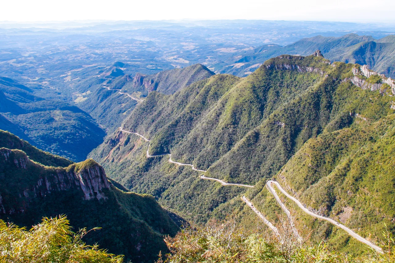
From the top, on a clear morning, you can see the Atlantic Ocean lying flat and silver a hundred kilometers to the east. Behind you the plateau stretches away in pale highland grass, sometimes white with frost. Below your feet the land simply ends, dropping away in cliffs, and a thin gray ribbon of asphalt is stitched down the face of it in switchback after switchback. This is the Serra do Rio do Rastro, the escarpment where the coastal lowlands of Santa Catarina rear up into the southern highlands, and the road draped across it is one of the most theatrical drives in Brazil.
The Folded Road
The SC-390 highway does not so much climb the serra as zigzag up its wall. Linking Lauro Müller at the foot to Bom Jardim da Serra on the plateau, the modern road was inaugurated in 1960 after a punishing feat of engineering, and its most famous stretch coils through a tight band of hairpins to overcome a drop of more than a thousand meters. The Santa Catarina infrastructure authorities count hundreds of sharp curves packed into a few kilometers, a density that has earned the road a reputation among drivers who collect such things. Photographs taken from the upper lookouts show the asphalt doubling back on itself so many times it looks less like a route than a coiled spring laid against the mountain.
Where the Air Turns Cold
Altitude rewrites the climate as you ascend. The highest point of the range stands at 1,460 meters above sea level, high enough that frosts are common through the colder months and snow can fall on the upper reaches, a rarity that draws Brazilians north and south to chase it. The ride takes you from humid Atlantic Forest near the base, green and dripping, up through cloud and into open highland where the wind cuts and the vegetation thins to grass and scattered shrubs. In a single morning a traveler can leave a subtropical coast and arrive somewhere that feels, briefly, like a different country at a higher latitude.
Deep Time in the Rock
The cliffs are not just scenery; they are a cross-section of the planet's past. These layers lend their name to the Rio do Rasto Formation, a band of ancient rock laid down some 260 million years ago in the Permian, when this part of Gondwana held river floodplains rather than mountains. Erosion has since carved the strata into the deep escarpment seen today, exposing the colored bands like pages in a book. The wildlife that lives among them includes the coati, a long-tailed, ring-marked relative of the raccoon often seen nosing along the lookouts at the summit, unbothered by the drop or the visitors leaning out to photograph the sea.
Standing at the Edge
Travelers come for the mirantes, the overlooks ranged along the upper road, where on a cloudless day the view runs unbroken from the highland down the folded asphalt to the distant glint of the Atlantic. When the clouds roll in, and they often do, the spectacle changes entirely: the lowlands vanish under a white sea of fog, and the road seems to descend straight into nothing. Either way the serra makes the same point. Few places let you watch a road wrestle with a mountain so plainly, every curve a small argument between human engineering and a wall of rock that would rather not be crossed.
From the Air
Serra do Rio do Rastro runs along roughly 28.41°S, 49.55°W in southeastern Santa Catarina, with the highest terrain reaching 1,460 m (about 4,790 ft) MSL. It marks the abrupt escarpment between the coastal plain and the interior plateau, so expect a sharp terrain step and a high risk of orographic cloud, fog banks, and rapid mountain weather. The switchbacked SC-390 is a striking visual landmark from the air, threading the cliff face between Lauro Müller and Bom Jardim da Serra. Nearest fields are Jaguaruna Regional Airport (ICAO SBJA) on the coast to the southeast and Diomício Freitas Airport near Criciúma; Florianópolis Hercílio Luz International (ICAO SBFL) lies well to the northeast. Maintain generous terrain clearance over the ridgeline and watch for downslope turbulence and reduced visibility along the escarpment. A morning or late-afternoon pass at safe altitude best reveals the folded road against the cliffs.
Nearby Stories
- Criciúma 3.7 km away
- Juliana Republic 13 km away
- Cambará do Sul 49 km away
- Florianópolis 66 km away
- Serra Geral National Park 83 km away
- Hercílio Luz Bridge 101 km away
- Vila Velha State Park 321 km away
- Grytviken 3020 km away