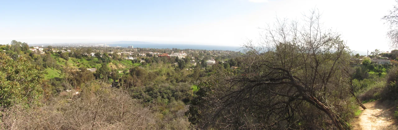
Topanga
The Tongva name Topaa'nga may mean 'where the mountain meets the sea,' or it may mean 'a place above.' Both readings fit. Topanga is a canyon cut into the Santa Monica Mountains between the San Fernando Valley to the north and the Pacific Coast Highway to the south — an unincorporated community of roughly 8,500 people occupying the largest unincorporated area in Los Angeles County. Topanga Creek, one of the area's few remaining undammed waterways, drains the canyon and empties into Santa Monica Bay. The creek still serves as a spawning ground for steelhead trout.
A Canyon with a History
The Tongva people lived here before Spanish colonization; bedrock mortars carved into rock outcroppings are found throughout the area. Topanga was colonized by Mexicans in 1839. By the 1920s, Hollywood stars were building weekend cottages in the rolling hills, attracted by the vegetation and the relative privacy the canyon offered. In the 1960s, Topanga became a destination for artists and counterculture figures. Wallace Berman settled in the area in 1965. Neil Young lived in Topanga, first with producer David Briggs, then in a house of his own. In 1970, he recorded most of After the Gold Rush in a basement studio there — one of the defining albums of its era, made in a canyon south of the San Fernando Valley. Charles Manson also lived in Topanga for a time, where he briefly befriended Young and Dennis Wilson of The Beach Boys. The canyon held opposites without resolving them.
The 300-Ton Boulder
On January 10, 2005, after heavy rains, a 25-foot, 300-ton boulder rolled down a hillside and landed on Topanga Canyon Boulevard. Photographs of the boulder were distributed internationally. It blocked through traffic between the San Fernando Valley and Pacific Coast Highway for most of a week — effectively severing the canyon's connection to both ends. Six-foot holes were drilled into the boulder; low-yield explosives were used to break it apart. A previous attempt with dynamite had failed because the rock was too saturated with rainwater. The boulder became, briefly, one of the more discussed objects in Southern California, a physical reminder that the canyon's geography, while scenic, operates on its own terms.
The 2025 Fire
The Palisades Fire, which ignited on January 7, 2025, severely affected the lower portion of Topanga. Most homes near Topanga State Beach were destroyed. The Topanga Ranch Motel, a historic property at Topanga State Park, burned. Topanga State Park itself lost 30 buildings including staff housing. The entirety of Topanga was placed under an evacuation order. The road closures and destruction replicated, in a more permanent way, the isolation the 2005 boulder had temporarily imposed. The fire affected a community that had long prided itself on a certain separateness from the larger city — people who chose the canyon specifically because it was different from Los Angeles, even while belonging to it.
What Topanga Remains
Topanga Canyon Boulevard, State Route 27, runs from the Ventura Freeway in the north to Pacific Coast Highway in the south, largely following Topanga Creek in its southern portion. The community of 8,560 people — as of the 2020 census — is zoned to Los Angeles Unified School District schools. A 1998 Los Angeles Magazine article noted that many students' parents are creative professionals, which was credited with contributing to the school's high test scores. Topanga has been described as an artists' colony in almost every decade since the 1960s. The creek continues to run. The undamaged sections of the canyon are still among the few places within Los Angeles County where the mountains and the sea feel genuinely close.
From the Air
Topanga sits at approximately 34.09°N, 118.604°W in the Santa Monica Mountains of western Los Angeles County. Topanga Canyon Boulevard is visible from altitude as a narrow road winding through steep terrain between the Ventura Freeway and Pacific Coast Highway. Nearest airports: Van Nuys Airport (VNY) about 10 miles northeast, Camarillo Airport (CMA) about 22 miles west.
Nearby Stories
- Grandma Prisbrey's Bottle Village 4.8 km away
- Battle of San Buenaventura 11 km away
- Historic Wintersburg in Huntington Beach, California 13 km away
- Point Hueneme Light 15 km away
- USS Ingersoll (DD-652) 22 km away
- Mount Lowe Railway 22 km away
- San Nicolas Island 64 km away
- Edwards Air Force Base 73 km away