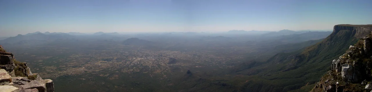

Tundavala Gap
Stand at the edge and the ground simply ends. One stride from your boots the rock falls away in a single clean drop of roughly a thousand meters, and where there should be more of Angola there is only sky, then haze, then the faint suggestion of a coastal plain so far below it seems to belong to another country. The wind comes up the cliff face in steady columns, carrying the smell of warm stone and dry grass. This is the Tundavala Gap, the place the Nyaneka people called Ntandavala, and the word fits: the space left between two sides.
The Edge of the Highlands
Tundavala sits about 18 kilometers from the highland city of Lubango, on the western lip of the Humpata Plateau in Huíla Province. The rim here climbs past 2,200 meters, while the plain spread out below lies roughly 1,000 meters down. This is not a gentle slope but a wall, the western limit of the Great Escarpment of Southern Africa, the same geological seam that runs for thousands of kilometers down the continent's edge. The escarpment draws a hard line between the cool, green highlands of Huíla and the parched lowlands of Namibe Province beyond. From the viewpoint the eye travels northwest across an estimated 10,000 square kilometers toward the old port of Moçâmedes. On a clear morning the curve of distance is almost dizzying. Lubango itself owes its cool, temperate air to this elevation, and the contrast is what gives the place its power. Behind you, grass and acacia and the everyday traffic of a provincial city. In front of you, a single step into nothing.
A Word for the Aperture
The name carries its own small mystery. Tundavala comes from the Nyaneka word Ntandavala, and the language offers it more than one meaning: what was attached and then stretched apart, what is open, the aperture, the gap between two sides. Each reading describes the place. The cliff is a kind of opening cut into the highlands, a doorway with nothing behind it but air. The local heritage runs deep enough that the gap lends its name to Lubango's Tundavala National Stadium, so that a feature of raw geology now turns up in the language of football fixtures and crowd noise, a reminder that landscapes shape the words a place lives by.
Honored and Protected
Angola has come to treat Tundavala as a national treasure rather than merely a scenic stop. On 21 August 2012 the government formally named the gap a cultural landscape, recognizing both its geology and its meaning to the people of the highlands. It is counted among the Seven Natural Wonders of Angola, and geologists prize it as a geoheritage site, a place where the deep architecture of the continent is laid open for anyone willing to make the drive. Visitors come for the silence as much as the view. There are few guardrails and little fanfare, just the rock, the drop, and the enormous bright emptiness that begins where the land gives out. People have died here, lured too close to an edge that offers no warning and no second chance, and that danger is part of what keeps the place honest. Tundavala is not a manicured overlook. It is a frontier between two worlds, and it asks to be respected as one.
The Beautiful Precipice
The same escarpment that makes Tundavala also gives the region its most famous road. A short distance south, the Serra da Leba pass pours off the highlands in a series of tight hairpin bends, dropping about a kilometer toward the coast in less than 30 kilometers of switchbacks. Engineered in the late colonial era and opened in the 1970s, its sweeping S-curves are so striking they appear on Angola's 2,000-kwanza banknote, and locals know the road as the beautiful precipice for its drama and its danger. Cliff and road belong to one story: the abrupt moment where the African plateau lets go and tumbles toward the Atlantic, an edge so sharp that people built a viewpoint, a stadium, and a piece of currency around it.
From the Air
Tundavala Gap lies at roughly 14.818 S, 13.381 E, on the western escarpment of the Humpata Plateau near Lubango, Huíla Province, southwestern Angola. The rim stands above 2,200 m (about 7,200 ft) with the lowland plain near 1,000 m, so the terrain drops nearly a kilometer in a single step facing northwest toward Moçâmedes and the coast. Approach from the highland side at safe terrain clearance and expect strong upslope winds, afternoon cloud buildup, and reduced visibility in haze season. The Serra da Leba switchbacks a short distance south are a striking visual landmark along the same cliff line. Nearest airport is Lubango (Mukanka) Airport (ICAO FNUB / IATA SDD), roughly 18 km east; Namibe (Yuri Gagarin) Airport on the coast serves the lowlands below.
Nearby Stories
- Tchitundu-Hulu 92 km away
- Moçâmedes 100 km away
- Operation Protea 206 km away
- Epupa Falls 212 km away
- Battle of Cassinga 219 km away
- Benguela 227 km away
- Mount Moco 265 km away
- Dutch Loango-Angola 733 km away