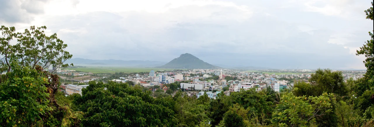

Tuy Hòa
Two mountains interrupt the flat coastal plain around Tuy Hòa, and they could not be more different. Chóp Chài rises in a blunt, forested cone. Nhạn Mountain — smaller, more abrupt — wears its history on its summit: a Cham tower that has been watching over the Đà Rằng River delta since long before the Vietnamese state claimed this coast. The city below grew up between those landmarks and the sea, shaped by the river that deposits new alluvium each wet season and by the rhythms of fishing and rice that that alluvium makes possible.
The River That Built a City
The Đà Rằng River — known in older maps as the Ba River — drains a vast highland watershed before pushing through a narrow gorge and spreading across the coastal plain. The alluvium it carries has made the land around Tuy Hòa some of the most productive agricultural terrain in Central Vietnam: deep, flat, well-watered, good for rice. The city itself spreads across that delta, its streets laid out on the kind of even ground that highland provinces rarely enjoy. Before Tuy Hoa's role as a provincial capital, it was first a market and port, a place where highland goods met coastal ones, and where the river's labor was converted into traded wealth.
Between Two Centers
Roughly midway between Nha Trang to the south and Qui Nhơn to the north, Tuy Hòa occupies a middle position that has always defined its character. It was never the largest city on this coast, never the most strategic, but always useful: a stop on National Route 1 before that road existed as pavement, a station on the North-South Railway linking Hanoi to Ho Chi Minh City, and today a stop served by Đông Tác Airport south of the city. That in-between quality is not a weakness. It means the city has developed on its own terms, less reshaped by the pressures that fall on major hubs. The pace here is noticeably different from Nha Trang's tourist-driven bustle.
The Cham Tower on Nhạn Mountain
Nhạn Tower — Tháp Nhạn — stands on the summit of Nhạn Mountain above the city, a Cham brick tower that pre-dates Vietnamese settlement of this coast. The Cham people, whose kingdom once stretched across much of what is now central and southern Vietnam, built towers like this as temples, typically dedicated to Hindu deities. Tháp Nhạn is no different: it is Shaivite in origin, part of a religious architecture spread over centuries across Cham-controlled territory. The Vietnamese word *nhạn* means swallow — the small swift bird — and looking up at the tower from the city, with swallows cutting arcs through the afternoon heat, the name feels exactly right. The view from the summit takes in the river, the delta, and the sea all at once.
Tropical Light and a Changing Map
Tuy Hòa has a tropical savanna climate — warm year-round, with a pronounced dry season and a wet season that can bring heavy rain and occasional typhoon damage. The light in the dry months is hard and clear, bleaching the streets white by midday and turning golden toward the sea in the late afternoon. In 2025, Vietnam's administrative reforms merged the former Phú Yên Province into the expanded Đắk Lắk province, making Tuy Hòa a ward of the new jurisdiction rather than a provincial capital. The city's geography and character did not change with the boundary lines, but its administrative position did — one more turn in a long history of being claimed by different maps.
From the Air
Tuy Hòa lies at approximately 13.09°N, 109.31°E along Vietnam's central coast. From the air, the city is easily identified by the Đà Rằng River's broad delta immediately to the south and the distinctive cone of Chóp Chài Mountain rising to the west. Nhạn Mountain, smaller, sits closer to the city center and can be spotted by its summit tower on clear days. Đông Tác Airport (ICAO: VVTH) lies just south of the urban area. Nearby references: VVPQ (Phù Cát) ~90 km north, VVNT (Cam Ranh) ~130 km south. Best viewing altitude for the delta and mountains: 3,000–5,000 feet.
Nearby Stories
- Sông Cầu 12 km away
- Chư Yang Sin National Park 32 km away
- Bidoup Núi Bà National Park 47 km away
- Po Nagar 63 km away
- Battle of Mang Yang Pass 82 km away
- South-East Asian Theatre of World War II 317 km away
- Kashmir Princess 380 km away
- Battle of the Paracel Islands 407 km away