
Tweed River (New South Wales)
A homesick explorer named this river after one a world away. In October 1823 John Oxley's party sheltered behind a small island near Point Danger, feasted on the turtles they caught there, and christened both the island and the stream that emptied beside it - the latter for the River Tweed that runs along the border of Scotland and England. The name has stuck for two centuries, and it suits a river that is itself a kind of border. For much of its lower course the Tweed traces the line between New South Wales and Queensland, gathering the runoff of a vanished volcano and carrying it down to a coast where two states, and two towns, meet at the same beach.
The River the Volcano Made
The Tweed is the drowned heart of a giant. It rises on the eastern slopes of the Great Dividing Range, inside a vast amphitheatre of mountains - the McPherson, Tweed, Burringbar and Condong ranges - that are the eroded rim of the ancient Tweed Volcano. Twenty-three million years ago this was a shield volcano spreading from Byron Bay to the Gold Coast; today the worn-down crater forms one of the largest erosion calderas in the southern hemisphere, with the spire of Wollumbin standing at its centre as the old volcanic plug. Over a course of just seventy-eight kilometres the river falls 173 metres and drains a catchment of more than a thousand square kilometres, fed by eight tributaries including the Oxley and the Rous before it reaches the Coral Sea south of Point Danger.
First Names, First People
Oxley was not the first to know this country, only the first to write English onto it. The valley and the coast around the river mouth are the lands of Aboriginal people whose languages - recorded under names such as Yugambeh and Bundjalung - reach across the Tweed Valley and north into the Gold Coast and Logan. When Oxley's companion John Uniack landed on the island near the river mouth, he marvelled at circular cavities worn into the basalt, one of them connected to the sea so that each returning surf threw up water with a loud noise - a blowhole in the volcanic rock. The early European accounts are a tangle of competing names and mistaken bearings: Captain Henry Rous, surveying in 1828, briefly muddled the Tweed with the Clarence and renamed Oxley's Turtle Island as Cook's Island. The river kept the Scottish name; the confusion was eventually sorted out.
Murwillumbah and the Flood Country
Downstream, the Tweed becomes a working river. It slides past Byangum, takes in the Oxley, and curves through Murwillumbah, the valley's main town, before braiding toward the sea. This is fertile, sub-tropical land - sugarcane, bananas, tropical fruit - but the same rainfall that makes it green can turn the river violent. The Tweed is serious flood country. When the remnants of Ex-Tropical Cyclone Debbie swept through in late March 2017, the gauge at Murwillumbah peaked at 6.2 metres and the town went under. Living beside the Tweed has always meant living with its moods, watching the brown water rise against the levee and recede again into the cane.
Where Two States Share a Beach
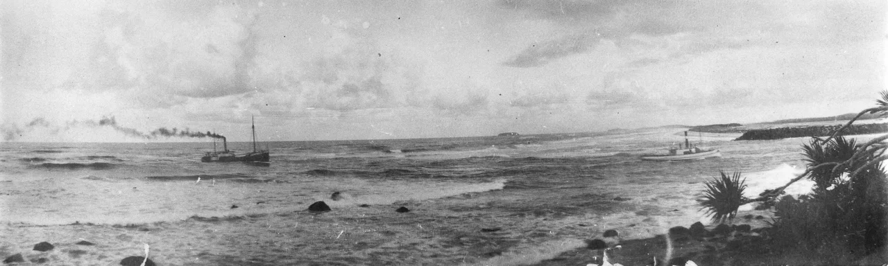
The river meets the ocean in one of the most engineered river mouths in Australia. The entrance sits at the doorstep of Tweed Heads and its Queensland twin Coolangatta, where the state line runs through the streets and, effectively, through the surf. The first training walls went up in 1891, and later extensions held the channel open but choked the natural northward drift of sand, starving the famous Gold Coast beaches. The fix, completed in 2001, is ingenious: a jetty on Letitia Spit vacuums sand from the river's south side and pumps it in a pipe beneath the Tweed, spitting it back onto the Queensland surf breaks at Duranbah, Snapper Rocks and Kirra. The river even marks a natural boundary of its own - the mouth is the southern limit of the Indo-Pacific humpback dolphin's range.
From the Air
The Tweed River reaches the sea at 28.17 degrees south, 153.56 degrees east, at Tweed Heads on the New South Wales / Queensland border. From the air it is one of the region's clearest navigation features: trace it inland (southwest) from the engineered, training-walled mouth and it leads straight toward Wollumbin / Mount Warning and the great green bowl of the Tweed caldera, ringed by the McPherson and Tweed ranges. The twin urban areas of Tweed Heads and Coolangatta sit on either side of the entrance. Gold Coast Airport (YBCG / OOL) lies immediately north of the river mouth at Coolangatta - its runway is barely 2 km from the entrance, so the lower river is busy controlled airspace. Ballina Byron Gateway (YBNA / BNK) is about 80 km south. Best viewed in clear morning light; the valley generates heavy afternoon convective cloud and the area is prone to dramatic flooding after sub-tropical lows.
Nearby Stories
- Ocean Shores, New South Wales 8.7 km away
- Warner Bros. Movie World 15 km away
- Purga Aboriginal Cemetery 31 km away
- Spicers Gap Road 53 km away
- Bald Rock National Park 95 km away
- HMS Porpoise (1799) 655 km away
- Wreck Reefs 684 km away
- SS Elingamite: Gold, Fog, and a Captain Wrongly Blamed 1825 km away